雷吉斯坦广场的建筑细节,撒马尔罕,乌兹别克斯坦 Building detail of Registan Square, Samarkand, Uzbekistan (© Piero M. Bianchi/Getty Images)

雷吉斯坦广场的建筑细节,撒马尔罕,乌兹别克斯坦 Building detail of Registan Square, Samarkand, Uzbekistan (© Piero M. Bianchi/Getty Images)
图案艺术的典范 A master class in pattern
雷吉斯坦广场的建筑细节
站在雷吉斯坦广场上,你很容易明白为什么这里被视为撒马尔罕的建筑核心——撒马尔罕是中亚最古老的城市之一。这座位于乌兹别克斯坦的广场三面矗立着三座宏伟的经学院——伊斯兰学术中心——它们高耸的门廊吸引着人们仰头观望。然而,广场上一些最珍贵的瑰宝,只有在你走近细看时才会显露出来。
今日图片中的细节让我们得以一窥几乎遍布每一处表面的精美艺术。琉璃砖、几何图案、花卉纹饰和优雅的书法以非凡的精确度融为一体,将砖石与灰泥化作绚丽夺目的色彩和图案展示。绿松石色、钴蓝色、金色和白色的色调随着光线变化而流转,使建筑在一天之中呈现出一种动态之感。
这些经学院最初作为学习和宗教学术研究中心而建,环绕着一座热闹的公共广场;这里曾是丝绸之路沿线的生活中心。如今,雷吉斯坦依然同样引人入胜,吸引游客欣赏其宏伟的规模和非凡的工艺。
Building detail of Registan Square, Samarkand, Uzbekistan
Stand in Registan Square and it's easy to see why it is considered the architectural heart of Samarkand—one of Central Asia's oldest cities. This plaza in Uzbekistan is framed by three magnificent madrasas—Islamic centers of learning—whose soaring portals draw the eye upward. Yet some of the square's greatest treasures reveal themselves only when you look closer.
The detail in today's image offers a glimpse of the artistry that covers nearly every surface. Glazed tiles, geometric motifs, floral designs, and elegant calligraphy come together with remarkable precision, turning brick and plaster into a dazzling display of color and pattern. Shades of turquoise, cobalt, gold, and white shift with the changing light, giving the architecture a sense of movement throughout the day.
Built as centers of learning and religious scholarship, the madrasas surrounded a lively public square that was once a focal point of life along the Silk Road. Today, Registan remains just as captivating, inviting visitors to admire both its monumental scale and its extraordinary craftsmanship.
冲浪者航拍图,圣卡塔琳娜州,巴西 Aerial view of surfers, Santa Catarina, Brazil (© Wonderful Nature/Shutterstock)

冲浪者航拍图,圣卡塔琳娜州,巴西 Aerial view of surfers, Santa Catarina, Brazil (© Wonderful Nature/Shutterstock)
读懂浪涛之间的讯息 Reading between the waves
冲浪者航拍图,圣卡塔琳娜州,巴西
在巴西南部圣卡塔琳娜州近海,图片捕捉到一种熟悉的仪式:冲浪者在碎浪之外等待,冲浪板随着大西洋的波涛起伏。从空中看,几乎什么都没有发生,但真正的功课正是在此时开始。
每一道海浪都携带着风所产生的能量,而那阵风可能来自数百甚至数千英里之外。挑战在于恰好在正确的时刻迎上这股远道而来的脉动。风、潮汐、洋流和海床形态共同决定每一道涌浪如何破碎;一个细微变化,就可能让完美的滑行变成翻滚的白浪。
很少有海岸线能比圣卡塔琳娜州更充分地展现这种多样性。这里拥有200多座海滩,从适合初学者的柔和浪点到世界级的管浪一应俱全。看似是一项运动,实则是在学习一种完全由流动海水诉说的语言。最优秀的冲浪者并不只是更强壮或更迅速,而是最懂得倾听的人。
Aerial view of surfers, Santa Catarina, Brazil
Off the coast of Santa Catarina, a state in southern Brazil, the image captures a familiar ritual: surfers waiting beyond the breaking waves, their boards rising and falling with the Atlantic. From above, almost nothing seems to happen. But that's when the real work begins.
Every wave carries energy generated by wind that may have blown hundreds or even thousands of miles away. The challenge is meeting that traveling pulse at just the right moment. Wind, tides, currents, and the shape of the seafloor determine how each swell will break, and a subtle shift can turn a perfect ride into tumbling whitewater.
Few coastlines showcase that variety better than Santa Catarina. With more than 200 beaches, it produces everything from gentle beginner breaks to world-class barrels. What looks like a sport is really learning a language spoken entirely in moving water. The best surfers aren't simply stronger or faster. They're the ones who know how to listen.
涨潮时的圣米歇尔山,芒什省,诺曼底,法国 Mont-Saint-Michel during high tide, Manche, Normandy, France (© Clement LEONARD/Getty Images)

涨潮时的圣米歇尔山,芒什省,诺曼底,法国 Mont-Saint-Michel during high tide, Manche, Normandy, France (© Clement LEONARD/Getty Images)
潮汐塑造的传奇 Where tides shape a legend
涨潮时的圣米歇尔山,诺曼底,法国
日落时分,圣米歇尔山从法国诺曼底的水面升起,宛如一座由海洋塑造的堡垒。修道院和村庄坐落在岩石潮汐岛上,矗立于欧洲最壮观的海岸环境之一。每天两次,海水退去,露出大片沙滩;随后潮水再次涌回,重新覆盖这片景观。涨潮时,圣米歇尔山又会变成一座岛屿。数百年来,旅行者一直根据这种潮汐节奏安排行程,在条件允许时穿越潮滩,并在数小时后观看海水归来。
传说这里的起源可追溯到708年:大天使米迦勒向一位主教显现,并指示他在此建造一座圣所。随着时间推移,这里发展为欧洲最重要的朝圣地之一。如今,圣米歇尔山及其周边海湾已被列入联合国教科文组织《世界遗产名录》;数百年的历史与潮汐运动仍在塑造每一次到访体验。
Mont-Saint Michel during high tide, Normandy, France
At sunset, Mont-Saint Michel rises from the waters of Normandy, France, like a fortress shaped by the sea. Perched on a rocky tidal island, the abbey and village stand at the center of one of Europe's most dramatic coastal settings. Twice a day, the sea retreats to reveal vast stretches of sand before surging back to reclaim the landscape. At high tide, the mount becomes an island once again. For centuries, travelers timed their journeys to this rhythm, crossing the flats when conditions allowed and watching the sea return hours later.
A legend traces the site's origins to the year 708, when the Archangel Michael appeared to a bishop and instructed him to build a sanctuary here. Over time, the site grew into one of Europe's most important pilgrimage destinations. Today, Mont-Saint Michel and its surrounding bay are recognized as a UNESCO World Heritage Site, where centuries of history and the movement of the tides continue to shape every visit.
基尔丘山上空的极光,冰岛 Auroras over Kirkjufell, Iceland (© Cavan Images/Alamy)

基尔丘山上空的极光,冰岛 Auroras over Kirkjufell, Iceland (© Cavan Images/Alamy)
流光溢彩的天空 A sky alive with color
基尔丘山上空的极光,冰岛
随着冰岛的夜晚再次变长,游客很快又会仰望天空,期待一睹北极光。北极光是一种发光现象,当来自太阳的粒子与地球高层大气中的气体相互作用时,便会形成闪烁的绿色、粉色、紫色,有时甚至是红色光带。冰岛地处北方,秋冬季夜晚日益漫长而黑暗,因此成为全球首屈一指的极光观赏地之一。
在这片不断变化的光幕之下,矗立着冰岛最常被拍摄的山峰之一——基尔丘山。它的冰岛语名称意为“教堂山”,源于其酷似教堂的外形。基尔丘山耸立在斯奈山半岛之上,醒目的轮廓和附近的基尔丘瀑布使这里深受摄影师和极光追寻者喜爱。在晴朗的夜晚,山峰、瀑布与天空交相辉映,构成一幅近乎不真实的画面;这一非凡组合已成为冰岛最具标志性的景观之一。
Auroras over Kirkjufell, Iceland
As darker nights return to Iceland, visitors will soon look to the skies for a chance to see the aurora borealis. Better known as the northern lights, this luminous phenomenon occurs when particles from the sun interact with gases high in Earth's atmosphere, creating shimmering ribbons of green, pink, purple, and sometimes red light. Iceland's northern location and increasingly dark autumn and winter nights make it one of the world's premier destinations for aurora viewing.
Beneath this ever-changing display stands Kirkjufell, one of the country's most photographed mountains. Its name means 'Church Mountain' in Icelandic, inspired by its church-like shape. Rising above the Snæfellsnes Peninsula, its striking silhouette and the nearby Kirkjufellsfoss waterfall have made the area a favorite of photographers and aurora seekers alike. On clear nights, the mountain, waterfall, and sky align in a scene that seems almost unreal—a remarkable combination that has become one of Iceland's most iconic views.
红木国家与州立公园的日出,加利福尼亚州,美国 Sunrise in Redwood National and State Parks, California, USA (© HadelProductions/Getty Images)
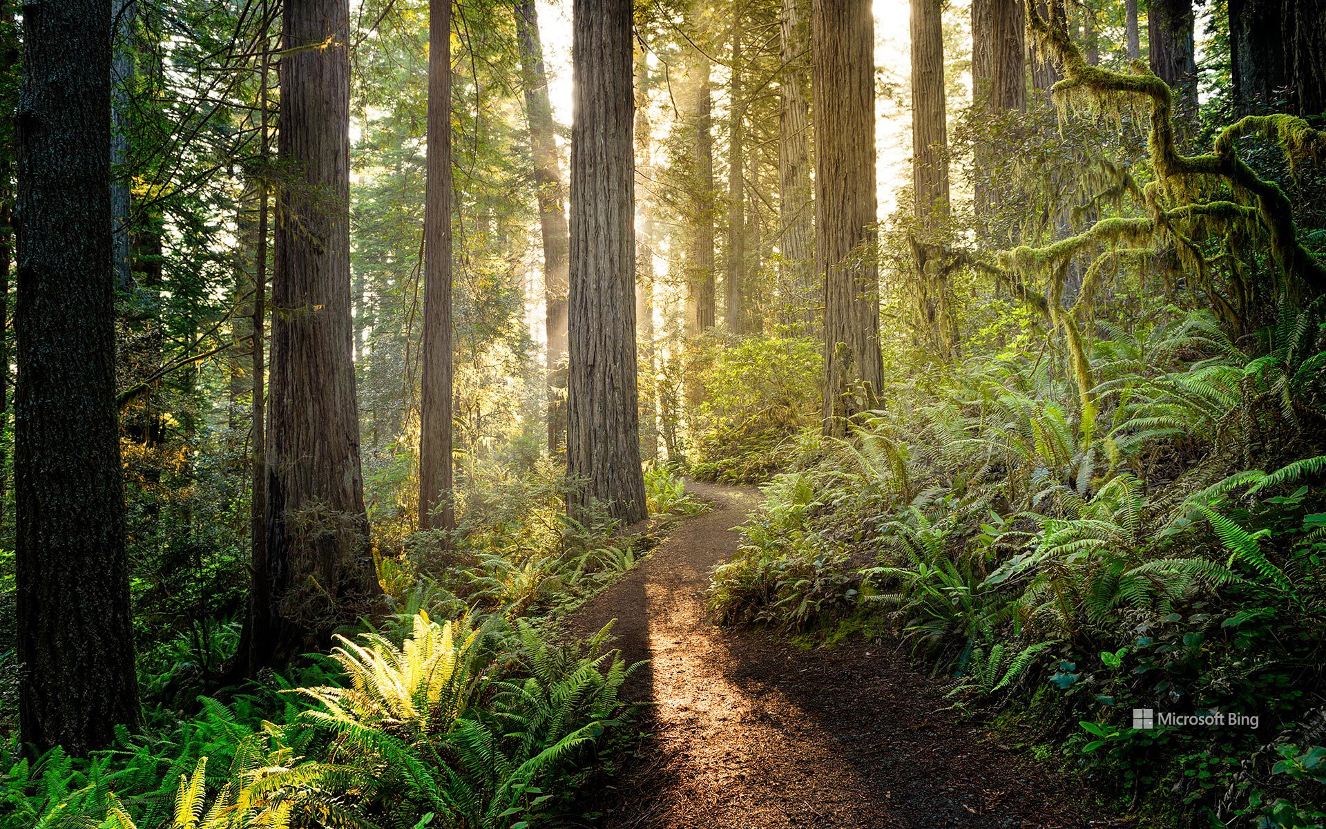
红木国家与州立公园的日出,加利福尼亚州,美国 Sunrise in Redwood National and State Parks, California, USA (© HadelProductions/Getty Images)
守护美国瑰宝 Protecting America's treasures
红杉国家公园与州立公园
110年来,美国最杰出的户外课堂始终向人们开放,供大家探索。8月25日,美国国家公园管理局迎来其守护美国自然与文化瑰宝一个多世纪的纪念日。1916年,伍德罗·威尔逊总统签署《组织法》使其成为法律,该机构由此成立;如今,它负责管理全美数百座公园、纪念地、海滨和历史遗址。由护林员带领的项目、家庭活动和教育活动邀请游客亲近那些塑造了国家公园体系的景观与故事。
今天的图片展示了加利福尼亚州北部的红木国家与州立公园,阳光照亮了一条蜿蜒穿行于地球上一些最高树木之间的小径。高耸的海岸红杉矗立在由蕨类植物和苔藓组成的葱郁林下植被之上,营造出一片既古老又充满生机的森林。这些林地是一个支撑着多种野生动物和数百年古树的生态系统的一部分,展现了美国国家公园管理局世世代代协助保护的自然奇观,也让游客有机会漫步于这些活着的巨树之下,体验一片独一无二的景观。
Anniversary of National Park Service
For 110 years, America's greatest outdoor classroom has been open for exploration. On August 25, the National Park Service marks over a century of protecting the nation's natural and cultural treasures. Established in 1916 when President Woodrow Wilson signed the Organic Act into law, the agency now cares for hundreds of parks, monuments, seashores, and historic sites across the country. Ranger-led programs, family activities, and educational events invite visitors to connect with the landscapes and stories that define the national park system.
Today's image shows Redwood National and State Parks in northern California, where sunlight illuminates a trail winding among some of the tallest trees on Earth. Towering coast redwoods rise above a lush understory of ferns and mosses, creating a forest that feels both ancient and alive. Part of an ecosystem supporting diverse wildlife and centuries-old trees, these groves showcase the natural wonders the National Park Service has helped protect for generations, offering visitors the chance to walk beneath living giants and experience a landscape unlike any other.
布鲁克林大桥,纽约市,美国 Brooklyn Bridge, New York City, USA (© shayes17/Getty Images)

布鲁克林大桥,纽约市,美国 Brooklyn Bridge, New York City, USA (© shayes17/Getty Images)
跨越历史 Crossing into history
布鲁克林大桥,纽约市
布鲁克林大桥连接的不只是曼哈顿和布鲁克林——它还连接着历史、工程学以及几个令人惊讶的故事。大桥历经14年建造,于1883年开放,成为世界上第一座钢丝悬索桥,永久改变了纽约人跨越东河的方式。
这项工程真正称得上是一项全家共同参与的事业。设计师约翰·A·罗布林去世,而他的儿子华盛顿又因病重而无法监督施工后,华盛顿的妻子艾米莉学习了工程学和高等数学,以监督项目的完工。
并非所有人都信任这座新建筑。1884年,演出商P.T.巴纳姆带领21头大象和17峰骆驼走过大桥,以证明它足够坚固。桥内隐藏的拱顶后来曾用于储存葡萄酒和香槟,之后又被用作冷战时期的放射性尘埃避难所;2006年,人们在那里重新发现了被遗忘的应急物资。如今,游隼在大桥的石塔顶部筑巢,证明这座标志性地标仍有许多翱翔高空的居民。有些桥梁就是永不过时。
Brooklyn Bridge, New York City
The Brooklyn Bridge doesn't just connect Manhattan and Brooklyn—it bridges history, engineering, and a few surprising stories too. Opened in 1883 after 14 years of construction, it became the world's first steel-wire suspension bridge, forever changing the way New Yorkers crossed the East River.
The project was a true family affair. After designer John A. Roebling died and his son Washington became too ill to oversee construction, Washington's wife, Emily, learned engineering and higher mathematics to supervise the project's completion.
Not everyone trusted the new structure. In 1884, showman P.T. Barnum marched 21 elephants and 17 camels across the bridge to prove it was strong enough. Hidden vaults inside the bridge later stored wine and champagne before serving as Cold War fallout shelters, where forgotten emergency supplies were rediscovered in 2006. Today, peregrine falcons nest atop its stone towers, proving this iconic landmark still has plenty of high-flying residents. Some bridges simply never go out of style.
在处暑时节的村庄田野与寺庙佛塔,江阴市,江苏省,中国 Village fields and a temple pagoda during the End of Heat solar term, Jiangyin City, Jiangsu Province, China (© jia yu/Getty Images)

在处暑时节的村庄田野与寺庙佛塔,江阴市,江苏省,中国 Village fields and a temple pagoda during the End of Heat solar term, Jiangyin City, Jiangsu Province, China (© jia yu/Getty Images)
暑气渐消,金秋已至 The receding heat brings golden autum
处暑时节
处暑时节将至,航拍视角下的古塔迎着晨雾耸立于渐染秋色的林木之间,生动呈现了暑气消退、金秋将至的自然韵律,以及中国传统文化景观的悠久魅力 。这一时节的传统习俗包括放河灯、迎秋赏景以及饮用中草药煎剂(如凉茶/防暑汤),以调和四季交替时的身体平衡 。
尤利尔山口蜿蜒的公路,瑞士 Winding road of Julier Pass, Switzerland (© Westend61/Getty Images)

尤利尔山口蜿蜒的公路,瑞士 Winding road of Julier Pass, Switzerland (© Westend61/Getty Images)
攀登在召唤 The climb is calling
尤利尔山口蜿蜒的公路,瑞士
有些山路本身就会成为旅行目的地,尤利尔山口正是其中之一。这座瑞士山口海拔高达7,493英尺,近2,000年来一直沿着一条路线连接着阿尔卑斯山的各个山谷。它的故事早在现代交通出现之前便已开始。没有护栏,也没有路面——只有一条供罗马时代的旅行者、商人和信使使用的路线。山顶附近的考古发现,包括无数枚硬币和两根罗马时期的皂石柱,表明这里可能曾有一处供攀越山口的人使用的圣所或歇脚处。
今天图片中所见的公路建于1820年至1828年间。1935年至1940年间,这座山口成为瑞士第一条铺设沥青的阿尔卑斯山公路。如今,每天约有3,000辆车通过尤利尔山口。冬季路况恶劣时,驾驶者可能需要安装防滑链。每一个回头弯都会带来又一番壮丽景色,让这段车程与目的地同样令人难忘。如果钥匙在你手中,你会选择这条风景优美的路线吗?
Winding road of Julier Pass, Switzerland
Some mountain roads become destinations in their own right, and Julier Pass is one of them. This Swiss mountain pass rises to 7,493 feet and has linked Alpine valleys along a route used for nearly 2,000 years. Its story began long before modern traffic. No guardrails, no pavement—just a route used by Roman travelers, merchants, and messengers. Archaeological finds near the summit, including countless coins and two Roman soapstone columns, suggest there was once a sanctuary or stopping place for those tackling the climb.
The road seen in today's image was built between 1820 and 1828. From 1935 to 1940, the pass became the first Swiss alpine road to be paved with asphalt. Today, roughly 3,000 vehicles cross Julier Pass every day. In winter, drivers may need snow chains when conditions are severe. Every switchback comes with another spectacular view, making the drive as memorable as the destination. If you had the keys, would you take the scenic route?
林恩运河中浮出水面的虎鲸,奇尔卡特山脉附近,阿拉斯加州,美国 An orca surfaces in Lynn Canal near the Chilkat Mountains, Alaska, USA (© John Hyde/Alamy)

林恩运河中浮出水面的虎鲸,奇尔卡特山脉附近,阿拉斯加州,美国 An orca surfaces in Lynn Canal near the Chilkat Mountains, Alaska, USA (© John Hyde/Alamy)
鲸群之声 Voices of the pod
奇尔卡特山脉附近的虎鲸,林恩运河,阿拉斯加州
在阿拉斯加东南部白雪覆盖的奇尔卡特山脉映衬下,一头虎鲸浮出林恩运河水面。虎鲸是海豚科体型最大的成员,也是海洋中最具辨识度的捕食者之一。阿拉斯加内湾航道寒冷且营养丰富的水域提供了充足的觅食地,既维系鲑鱼洄游,也滋养种类繁多的海洋生物,为这些非凡动物提供支持。
科学家确认了数个不同的虎鲸种群,各自拥有独特的食谱、狩猎策略和社会传统。有些专门捕鱼,有些则捕食海豹、海狮及其他海洋哺乳动物。虎鲸生活在由经验丰富的年长雌鲸带领、关系紧密的家族群体中,并通过每个鲸群特有的叫声交流——这种声音传统代代相传。林恩运河及其周边水道为这些高度聪明的海洋哺乳动物提供了重要栖息地,也是野外观察它们的壮丽场所。
An orca near the Chilkat Mountains, Lynn Canal, Alaska
An orca breaks the surface of Lynn Canal against the backdrop of the snow-capped Chilkat Mountains in Southeast Alaska. Also known as the killer whale, the orca is the largest member of the dolphin family and one of the ocean's most recognizable predators. The cold, nutrient-rich waters of Alaska's Inside Passage provide abundant feeding grounds, sustaining salmon runs and a rich variety of marine life that supports these remarkable animals.
Scientists recognize several distinct orca populations, each with its own diet, hunting strategies, and social traditions. Some specialize in catching fish, while others prey on seals, sea lions, and other marine mammals. Living in tightly bonded family groups led by experienced older females, orcas communicate through distinctive calls unique to each pod—vocal traditions passed down through generations. Lynn Canal and its surrounding waterways offer a vital habitat for these highly intelligent marine mammals and a dramatic setting for observing them in the wild.
怀特克利夫公园,西温哥华,加拿大 Whytecliff Park, West Vancouver, Canada (© Aolin Chen/Getty Images)

怀特克利夫公园,西温哥华,加拿大 Whytecliff Park, West Vancouver, Canada (© Aolin Chen/Getty Images)
浪潮间的通道 A path between the waves
怀特克利夫公园,西温哥华,加拿大
通往此处的最佳路径并非由混凝土铺就。每当退潮时,一条岩石小径便会显露出来,连接着加拿大西温哥华的怀特克利夫公园(Whytecliff Park)与怀特小岛(Whyte Islet)。数小时后,海水会悄然漫过这条通道,将“把握时机”也变成了体验的一部分。这片海岸线吸引着一代又一代的游客:潮汐开辟了道路,而湿滑的岩石则让人心存敬畏;作为回报,你将收获回望海滩与格伦伊格尔斯(Gleneagles)山坡民居时的壮丽景致。
怀特克利夫公园(Whytecliff Park)得名于曾矗立在这段海岸线上的浅色悬崖;1993年,其周边海域成为加拿大首个咸水海洋保护区,从而在历史上留下了浓墨重彩的一笔。如今,这片海域栖息着200多种海洋生物,使该公园成为水肺潜水爱好者和野生动物观察者的热门去处。人们常能看到港海豹在近岸处出没,甚至还有虎鲸曾在此海域现身。游览完公园后,游客还可以前往灯塔公园(Lighthouse Park)探索一番,或是徒步前往赛普拉斯瀑布公园(Cypress Falls Park)欣赏瀑布美景,为一天的行程画上圆满句号。