地肤田,中国 Field of kochia plants, China (© lingqi xie/Getty Images)

地肤田,中国 Field of kochia plants, China (© lingqi xie/Getty Images)
坚韧在此扎根 Where toughness takes root
地肤田,中国
在今天的画面中,中国大地上铺展着绿色与深红色的地肤。地肤原产于欧亚大陆部分地区,19世纪末作为观赏植物和制作扫帚的材料来源被引入美国。它耐旱、耐热、耐盐碱土壤和少雨环境的能力,帮助其扩散至美国大平原及美国西部大部分地区。
地肤由种子迅速生长,单株在一个生长季内便可长到数英尺高,并产生数千粒种子。幼株可用作牲畜饲料,尤其是在其他植被稀少的干旱地区。地肤因醒目的色彩和顽强的生命力而受人欣赏,但农民也将它视为一种难以治理的耐性杂草。从美国大草原到画面中中国色彩绚丽的田野,它始终是自然适应能力的非凡例证。
Field of kochia plants, China
In today's image, kochia plants spread across the landscape in China in shades of green and deep red. Native to parts of Eurasia, kochia was introduced to the United States in the late 1800s as an ornamental plant and a source of material for broom making. Its ability to withstand drought, heat, saline soils, and low rainfall helped it spread across the Great Plains and much of the American West.
Growing quickly from seed, a single plant can reach several feet tall in one season and produce thousands of seeds. Young plants have been used as forage for livestock, particularly in dry regions where other vegetation is scarce. While admired for its striking colors and resilience, kochia is also known to farmers as a hardy weed that can be difficult to control. From American prairies to the vibrant fields seen here in China, it remains a remarkable example of nature's adaptability.
米苏里纳群峰,多洛米蒂山脉,威尼托大区,意大利 Cadini di Misurina, Dolomites, Veneto, Italy (© Vithun Khamsong/Getty Images)

米苏里纳群峰,多洛米蒂山脉,威尼托大区,意大利 Cadini di Misurina, Dolomites, Veneto, Italy (© Vithun Khamsong/Getty Images)
高处的珊瑚礁 A reef above its station
米苏里纳群峰,多洛米蒂山脉,威尼托大区,意大利
画面捕捉了意大利东北部威尼托大区米苏里纳群峰日出时的锯齿状天际线。前往附近三峰山的游客,往往本为那条著名路线而来,却发现自己的目光被米苏里纳群峰吸引。作为多洛米蒂山脉的一部分,这些针状山峰最高处超过9,300英尺,仿佛专为营造戏剧效果而雕琢。出人意料的是,它们最初是古老的珊瑚礁。
大约2.5亿年前,这一地区位于温暖的热带海洋之下。随着非洲板块与欧亚板块碰撞,海床被抬升到数千英尺高空;昔日由鱼儿游过的悬崖中,至今保存着贝壳及其他海洋化石,如今则由徒步者探索。
日出和日落时分,多洛米蒂山脉在被称为“恩洛萨蒂拉”(enrosadira)的高山奇观中闪烁着粉色与橙色的光芒,让这些古礁石仿佛由内而外被点亮。如今,这处联合国教科文组织世界自然遗产保存着地质学上最不可思议的故事之一。从珊瑚礁到耸立的天际线,鲜少有地方经历过如此漫长而巨大的沧桑巨变。
Cadini di Misurina, Dolomites, Veneto, Italy
The image captures the jagged skyline of Cadini di Misurina at sunrise in Veneto, northeastern Italy. Visitors heading toward nearby Tre Cime di Lavaredo often come for the famous route only to find their attention hijacked by the Cadini. Part of the Dolomites, these needle-like peaks reaching more than 9,300 feet at their highest point seem sculpted for drama. The twist? They started out as ancient coral reefs.
Around 250 million years ago, this region lay beneath a warm tropical sea. As the African and Eurasian tectonic plates collided, the seabed was thrust thousands of feet into the sky, preserving shells and other marine fossils in cliffs now explored by hikers instead of fish.
At sunrise and sunset, the Dolomites glow pink and orange in the Alpine phenomenon known as 'enrosadira,' making these former reefs appear almost lit from within. Today, this UNESCO World Heritage Site preserves one of geology's most improbable stories. From coral reef to mountain skyline, few places have traveled farther.
滨海自由城,法国里维埃拉,法国 Villefranche-sur-Mer, French Riviera, France (© StockByM/Getty Images)

滨海自由城,法国里维埃拉,法国 Villefranche-sur-Mer, French Riviera, France (© StockByM/Getty Images)
地中海风情尽显 A patchwork from above
滨海自由城,法国里维埃拉
九月,法国里维埃拉沐浴在更柔和的光线中,地中海植被也逐渐恢复生机。山丘间弥漫着阿勒颇松、迷迭香和野百里香的芳香。内陆地区,百年橄榄树和山顶村庄讲述着一个由希腊、罗马和普罗旺斯影响共同塑造的故事。
沿着海岸步道,冬青栎和草莓树经受住夏季干旱,无花果树则仍结满成熟果实。在滨海自由城等海滨城镇的海湾中,帆船和游艇优雅地滑行于海天之间;埃斯泰雷勒山地的红色岩石,与深绿色的地中海灌木丛形成鲜明对比。
在一处幽静海湾周围,蝉鸣渐渐淡去,气氛也愈发宁静。法国里维埃拉远不只是一幅明信片般完美的风景:这里是自然、遗产与生活艺术的和谐交融,地中海在此占据绝对主导。
奥尔韦拉航拍图,安达卢西亚,西班牙 Aerial view of Olvera, Andalusia, Spain (© Marco Bottigelli/Getty Images)

奥尔韦拉航拍图,安达卢西亚,西班牙 Aerial view of Olvera, Andalusia, Spain (© Marco Bottigelli/Getty Images)
俯瞰大地拼图 A patchwork from above
奥尔韦拉航拍图,安达卢西亚,西班牙
你是否想过,安达卢西亚为何是西班牙最著名的地区之一?弗拉门戈、塔帕斯、摩尔式建筑和广阔的橄榄林都功不可没。在那些名城之外,还有奥尔韦拉这样的历史古镇。这座村庄被200多万棵橄榄树环绕,作为战略边境聚落发展而来,并在数百年的变迁中成形。奥尔韦拉城堡依然俯瞰着全镇,下方的化身圣母教堂则主导着天际线。前往拉西利亚文化中心,可以了解奥尔韦拉的中世纪历史与传统。
饿了吗?可以尝尝“gazpacho”冷番茄汤、西班牙著名的“jamón ibérico”伊比利亚火腿,或酥脆的“torta de aceite”橄榄油薄饼。若想散步或骑行欣赏风景,可前往塞拉山绿色之路——一条由旧铁路线改造而成的热门步道。在陡峭的鹅卵石街道上要留心脚下:相机也许端得稳,脚步可未必!正如俗语所说,“poco a poco”——慢慢来。放慢脚步,随意漫步,让奥尔韦拉一点点展现自己。
Aerial view of Olvera, Andalusia, Spain
Ever wondered why Andalusia is one of Spain's best-known regions? Flamenco, tapas, Moorish architecture, and extensive olive groves all play a part. Beyond its famous cities, you'll find historic places like Olvera. Surrounded by more than 2 million olive trees, this village developed as a strategic frontier settlement shaped by centuries of change. The Castle of Olvera still watches over the town, while the Church of Our Lady of the Incarnation dominates the skyline below. Visit La Cilla Cultural Center to discover Olvera's medieval history and traditions.
Hungry? Try 'gazpacho,' a chilled tomato soup; 'jamón ibérico,' Spain's famous cured ham; or the 'torta de aceite,' a crisp olive oil biscuit. For a scenic walk or bike ride, head to the Vía Verde de la Sierra, a former railway line turned popular trail. Watch your step on the steep cobbled streets—your camera might stay steady, but your footing may not! As the saying goes, 'poco a poco'—little by little. Slow down, wander, and let Olvera reveal itself.
安科拉附近的加比特凯尼海滩,卡纳塔克邦,印度 Gabit Keni Beach near Ankola, Karnataka, India (© Amith Nag Photography/Getty Images)
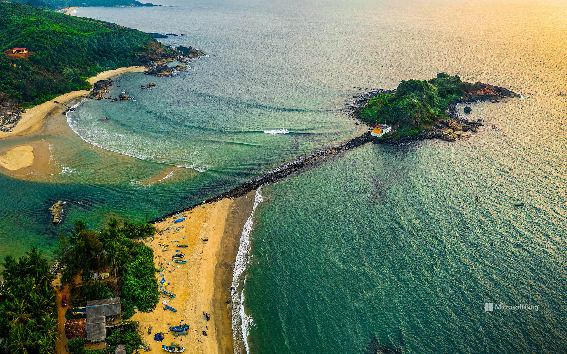
安科拉附近的加比特凯尼海滩,卡纳塔克邦,印度 Gabit Keni Beach near Ankola, Karnataka, India (© Amith Nag Photography/Getty Images)
印度西海岸的生活 Life on India's west coast
安科拉附近的加比特凯尼海滩,卡纳塔克邦,印度
提到印度南部,人们常会想到香料贸易路线、古典音乐、民间舞蹈,以及数百年来连接印度与世界的海岸线。沿着这条海岸向西进入卡纳塔克邦,便会抵达安科拉附近一处更宁静的停靠点:加比特凯尼海滩。这里的生活围绕阿拉伯海展开,渔船在黎明前出海,载着当天的渔获归来。
这片海滩以加比特渔民社区命名。探索北卡纳达县时,这里是个轻松顺路的停靠点,尤其适合与戈卡尔纳、卡尔瓦尔和历史悠久的米尔詹堡一同游览。观鸟者可能在溪流附近看到海岸鸟类,摄影者则常在清晨光线更柔和时驻足。何不尝尝当地美食?安科拉周边餐馆里,新鲜鱼咖喱、炸鱿鱼和鲜虾菜肴都很受欢迎。离开之前,不妨留出时间享用一顿新鲜海鲜;它或许会和这片海滩一样令人难忘。
Gabit Keni Beach near Ankola, Karnataka, India
When people think of South India, they often picture spice trade routes, classical music, folk dances, and a coastline that has connected India with the world for centuries. Follow that coastline west into Karnataka and you'll reach a quieter stop near Ankola: Gabit Keni Beach. Life here revolves around the Arabian Sea, with fishing boats setting out before dawn and returning with the day's catch.
The beach is named after the Gabit fishing community. It's an easy stop while exploring the Uttara Kannada district, especially alongside Gokarna, Karwar, and the historic Mirjan Fort. Birdwatchers may spot coastal birds near the stream, while photographers often stop by during the softer light of early morning. Why not sample local cuisine? Fresh fish curries, squid fry, and prawn dishes are popular at eateries around Ankola. Before you leave, make time for a fresh seafood meal—it may end up being as memorable as the beach itself.
东米恩南唐斯国家公园谷物田中的山毛榉树,汉普郡,英格兰 Beech tree in a cereal field, East Meon, South Downs National Park, Hampshire, England (© Guy Edwardes/Minden Pictures)

东米恩南唐斯国家公园谷物田中的山毛榉树,汉普郡,英格兰 Beech tree in a cereal field, East Meon, South Downs National Park, Hampshire, England (© Guy Edwardes/Minden Pictures)
金色田野 Fields of gold
汉普郡谷物田中的山毛榉树,英格兰
在汉普郡东米恩附近的金色田野中,一棵山毛榉独自挺立,成为英格兰南唐斯国家公园起伏景观中的醒目焦点。数百年来,农业塑造着这些白垩丘陵;时至今日,耕作仍是该地区的重要组成部分。当地排水良好的白垩土壤支撑着大规模旱作农业,其中小麦和大麦是最常见的作物。整个夏季,作物在田间逐渐成熟,随后收获季将乡野变成金色田块与麦茬交织的拼图。
9月初正值主要收获季,乡村社区开始庆祝一年的丰收。在东米恩等村庄,收获传统仍是当地生活中经久不衰的一部分,反映出土地与耕作者之间的深厚联系。以开阔天空和连绵农田为背景,这棵孤树象征着南唐斯悠久的农业遗产。
Beech tree in a cereal field, Hampshire, England
A beech tree stands alone amid golden fields near East Meon in Hampshire, providing a striking focal point in the rolling landscape of England's South Downs National Park. Agriculture has shaped these chalk hills for centuries, and farming remains an important part of the region today. The area's free-draining chalk soils support extensive arable farming, with wheat and barley among the most common crops. Throughout the summer, these crops ripen in the fields before harvest transforms the countryside into a patchwork of gold and stubble.
Early September coincides with the main harvest season, when rural communities begin celebrating the year's bounty. In villages such as East Meon, harvest traditions remain an enduring part of local life, reflecting the deep connection between the land and the people who work it. Framed by open skies and sweeping farmland, this solitary tree stands as a symbol of the South Downs' long agricultural heritage.
老市政厅,班贝格,德国 Old Town Hall, Bamberg, Germany (© SCStock/Getty Images)

老市政厅,班贝格,德国 Old Town Hall, Bamberg, Germany (© SCStock/Getty Images)
历史沿运河流淌之地 Where history flows along the canal
老市政厅,班贝格,德国
班贝格老市政厅高踞于雷格尼茨河上,是德国班贝格最具代表性的地标之一。当地传说称,这座建筑之所以矗立在人工岛上,是因为城里的主教拒绝向市民提供修建市政厅的土地。据说居民于是自行在河中央造出一块地基,成就了这座建筑非凡的环境和历久弥新的魅力。
这座建筑融合了哥特式和巴洛克式建筑元素,色彩缤纷的外墙上装饰着精美的湿壁画。一座石桥将市政厅与历史城区两岸相连,构成巴伐利亚最常被拍摄的景观之一。
如今,老市政厅仍是班贝格丰富遗产与独特气质的象征。周围蜿蜒的街道、历史建筑和河畔风光,让人得以一窥当地数百年的历史,并继续吸引着来自世界各地的游客。
菲安斯湖,格兰屏国家公园,维多利亚州,澳大利亚 Lake Fyans, Grampians National Park, Victoria, Australia (© tracielouise/Getty Images)

菲安斯湖,格兰屏国家公园,维多利亚州,澳大利亚 Lake Fyans, Grampians National Park, Victoria, Australia (© tracielouise/Getty Images)
倒影满湖的水库 A reservoir of reflections
菲安斯湖,格兰屏国家公园,维多利亚州,澳大利亚
乍看之下,今天的画面更像一片被淹没的林地,而不是湖泊。光秃的树干从水中伸出,倒影横贯水面,远处的格兰屏群山熠熠生辉。这里是菲安斯湖,一座位于澳大利亚维多利亚州格兰屏(加里维德)国家公园边缘的人工水库。这里深受划船者、垂钓者、帆船爱好者和滑水者欢迎,也为人们提供了欣赏澳大利亚最壮美景观之一的绝佳前排视角。
湖泊远处的群山属于格兰屏山脉,这条山脉历经数亿年塑造而成。如今,该地区以崎岖的砂岩山峰、壮观的观景台、瀑布和丰富的澳大利亚原住民文化遗产闻名。步道纵横交错,带领徒步者欣赏开阔景致,并邂逅袋鼠、鸸鹋及其他本土鸟类。菲安斯湖将这种荒野精神浓缩在同一幅画面中:被淹没的树木、开阔的天空,以及以古老群山构成的瞬息万变的背景。
Lake Fyans, Grampians National Park, Victoria, Australia
At first glance, today's image looks more like a drowned woodland than a lake. Bare tree trunks emerge from the water, their reflections stretching across the surface as the Grampians glow in the distance. This is Lake Fyans, an artificial reservoir on the edge of the Grampians (Gariwerd) National Park in Victoria, Australia. Popular with boaters, anglers, sailors, and water-skiers, it offers a front-row seat to one of the country's most striking landscapes.
The mountains beyond the lake are part of the Grampians, a range shaped over hundreds of millions of years. Today, the region is known for its rugged sandstone peaks, dramatic lookouts, waterfalls, and rich Aboriginal cultural heritage. Trails crisscross the park, leading hikers to sweeping views and encounters with kangaroos, emus, and other native birds. Lake Fyans captures that wild spirit in a single scene: flooded trees, open skies, and an ever-changing backdrop of ancient mountains.
韦斯特黑弗的韦斯特黑弗桑德灯塔,石勒苏益格-荷尔斯泰因州,德国 Westerheversand Lighthouse in Westerhever, Schleswig-Holstein, Germany (© bluejayphoto/Getty Images)

韦斯特黑弗的韦斯特黑弗桑德灯塔,石勒苏益格-荷尔斯泰因州,德国 Westerheversand Lighthouse in Westerhever, Schleswig-Holstein, Germany (© bluejayphoto/Getty Images)
地平线上的红与白 Red and white on the horizon
韦斯特黑弗桑德灯塔, 德国
韦斯特黑弗桑德灯塔高耸于德国北海沿岸的盐沼之上,凭借醒目的红白条纹一眼便可辨认。灯塔建于1906年至1908年间,一个多世纪以来一直是艾德施泰特半岛的标志,为穿行北海水域的船只指引航向。如今,它仍是德国北部最著名的海岸地标之一。登上157级台阶的游客,可以饱览周围的壮阔景色。
一条狭窄的潮汐水道蜿蜒穿过沼泽,将视线引向远处的条纹灯塔。周围景观属于石勒苏益格-荷尔斯泰因瓦登海国家公园,并位于已列入联合国教科文组织《世界遗产名录》的瓦登海之中。受潮汐持续律动的塑造,这片非凡的海岸环境会随着水位涨落在一天中不断变化。盐沼和广阔潮滩孕育了丰富多样的野生动物,使瓦登海成为世界上最重要的湿地生态系统之一。
Westerheversand Lighthouse, Schleswig-Holstein, Germany
Rising above the salt marshes along Germany's North Sea coast, the Westerheversand Lighthouse is instantly recognizable thanks to its distinctive red-and-white stripes. Built between 1906 and 1908, the lighthouse has stood as an icon on the Eiderstedt Peninsula for more than a century, guiding ships through the waters of the North Sea. Today, it remains one of northern Germany's best-known coastal landmarks. Visitors who climb its 157 steps are rewarded with sweeping views of the surrounding scenery.
A narrow tidal channel meanders through the marshland, leading the eye toward the striped beacon in the distance. The surrounding landscape is part of the Schleswig-Holstein Wadden Sea National Park, within the UNESCO World Heritage-listed Wadden Sea. Shaped by the constant rhythm of tides, this remarkable coastal environment changes throughout the day as water levels rise and fall. Salt marshes and extensive tidal flats support a rich variety of wildlife, making the Wadden Sea one of the world's most important wetland ecosystems.
郊狼丘,朱红悬崖国家纪念区,亚利桑那州,美国 Coyote Buttes, Vermilion Cliffs National Monument, Arizona, USA (© James Hager/Getty Images)

郊狼丘,朱红悬崖国家纪念区,亚利桑那州,美国 Coyote Buttes, Vermilion Cliffs National Monument, Arizona, USA (© James Hager/Getty Images)
一部守护荒野的法案 An act of wilderness
郊狼丘,朱红悬崖国家纪念区,亚利桑那州
波浪通常属于海洋。但在亚利桑那州北部,它们却从沙漠中涌起。郊狼丘是朱红悬崖国家纪念区的一部分,其盘旋起伏的砂岩地貌由远古沙丘和数百万年的侵蚀共同塑造而成,造就了一片即使静止不动也仿佛泛着涟漪的景观。
正是由于存在这样的地方,1964年《荒野法》才于9月3日签署成为法律,而今天正是纪念这一里程碑的日子。由于担心不断发展的国家可能会改变国土上几乎每一个角落,国会设立了国家荒野保护体系,以保护那些保留自然风貌,并为人们提供独处、探索和发现机会的土地。
该法案最初保护了54片荒野地区,占地910万英亩。六十多年后的今天,这一体系覆盖的全国土地已超过1.1亿英亩。从偏远森林到经自然雕琢的沙漠岩层,这些受保护的景观邀请游客体验美国的另一面——它并非由蓝图塑造,而是由时间本身铸就。
Coyote Buttes, Vermilion Cliffs National Monument, Arizona
Waves usually belong to the ocean. In northern Arizona, they rise from the desert instead. The swirling sandstone formations of Coyote Buttes, part of Vermilion Cliffs National Monument, were shaped by ancient dunes and millions of years of erosion, creating a landscape that seems to ripple even while standing still.
Places like this are one reason the Wilderness Act of 1964 was signed into law on September 3, a milestone commemorated today. Concerned that an expanding nation could transform nearly every corner of the country, Congress established the National Wilderness Preservation System to protect lands that retain their natural character and offer opportunities for solitude, exploration, and discovery.
The act initially safeguarded 54 wilderness areas covering 9.1 million acres. More than six decades later, the system now encompasses over 110 million acres nationwide. From remote forests to sculpted desert rock, these protected landscapes invite visitors to experience a side of America shaped not by blueprints, but by time itself.