卡西洛夫河冰川融水滋养的湛蓝河水,阿拉斯加州,美国 The blue, glacier-fed waters of the Kasilof River, Alaska, USA (© jared lloyd/Getty Images)
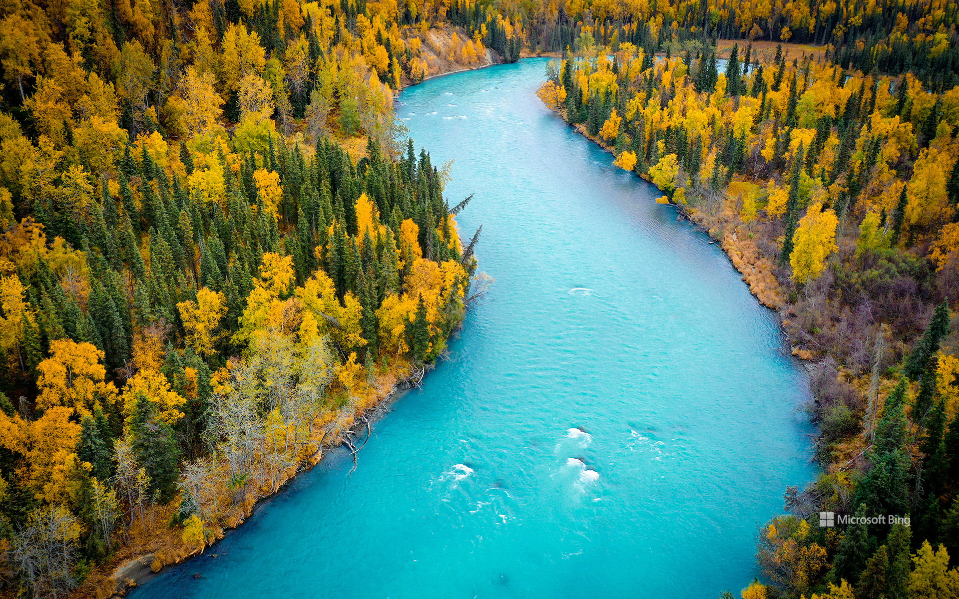
卡西洛夫河冰川融水滋养的湛蓝河水,阿拉斯加州,美国 The blue, glacier-fed waters of the Kasilof River, Alaska, USA (© jared lloyd/Getty Images)
冰川孕育之河 Born of glaciers
阿拉斯加州卡西洛夫河由冰川补给的蓝色河水
从空中俯瞰,卡西洛夫河宛如一条绿松石色的丝带,蜿蜒穿过阿拉斯加州的基奈半岛。鲜艳的蓝色河水源于从图斯图梅纳湖向下游输送的冰川粉砂;该湖是阿拉斯加州最大的淡水湖之一。河流全长约17英里,最终注入库克湾。它虽比著名的邻河基奈河短,却同样不同凡响。
卡西洛夫河发源于冰塑地貌,与当地的渔业文化始终密不可分。长期以来,这条河一直是德纳伊纳人的重要资源,后来又成为商业捕捞、生计捕捞和休闲垂钓的重地。如今,垂钓者为洄游的鲑鱼而来,游客则可探索附近的休闲场所、露营地和自然步道。卡西洛夫社区本身是半岛西海岸的一座小渔镇;这里的河流、森林和河口栖息地滋养着丰富的野生动物。无论从漂流艇上还是空中观赏,卡西洛夫河都能让人鲜明地窥见阿拉斯加的冰川起源,以及这片土地与水之间绵延不绝的联系。
The blue, glacier-fed waters of the Kasilof River, Alaska
Seen from above, the Kasilof River winds like a ribbon of turquoise through Alaska's Kenai Peninsula. The vivid blue water comes from glacial silt carried downstream from Tustumena Lake, one of the largest freshwater lakes in the state. Flowing about 17 miles before emptying into Cook Inlet, the river is shorter than its famous neighbor, the Kenai, but no less remarkable.
The Kasilof begins in a landscape shaped by ice and remains closely tied to the region's fishing culture. Long an important resource for the Dena'ina people, the river later became central to commercial, subsistence, and recreational fishing. Today, anglers come for salmon runs, while visitors explore nearby recreation sites, campgrounds, and nature trails. The community of Kasilof itself is a small fishing town on the peninsula's west coast, where river, forest, and estuary habitats support abundant wildlife. Whether viewed from a drift boat or from the air, the Kasilof offers a striking glimpse of Alaska's glacial origins and enduring connection to the water.
林恩运河中浮出水面的虎鲸,奇尔卡特山脉附近,阿拉斯加州,美国 An orca surfaces in Lynn Canal near the Chilkat Mountains, Alaska, USA (© John Hyde/Alamy)

林恩运河中浮出水面的虎鲸,奇尔卡特山脉附近,阿拉斯加州,美国 An orca surfaces in Lynn Canal near the Chilkat Mountains, Alaska, USA (© John Hyde/Alamy)
鲸群之声 Voices of the pod
奇尔卡特山脉附近的虎鲸,林恩运河,阿拉斯加州
在阿拉斯加东南部白雪覆盖的奇尔卡特山脉映衬下,一头虎鲸浮出林恩运河水面。虎鲸是海豚科体型最大的成员,也是海洋中最具辨识度的捕食者之一。阿拉斯加内湾航道寒冷且营养丰富的水域提供了充足的觅食地,既维系鲑鱼洄游,也滋养种类繁多的海洋生物,为这些非凡动物提供支持。
科学家确认了数个不同的虎鲸种群,各自拥有独特的食谱、狩猎策略和社会传统。有些专门捕鱼,有些则捕食海豹、海狮及其他海洋哺乳动物。虎鲸生活在由经验丰富的年长雌鲸带领、关系紧密的家族群体中,并通过每个鲸群特有的叫声交流——这种声音传统代代相传。林恩运河及其周边水道为这些高度聪明的海洋哺乳动物提供了重要栖息地,也是野外观察它们的壮丽场所。
An orca near the Chilkat Mountains, Lynn Canal, Alaska
An orca breaks the surface of Lynn Canal against the backdrop of the snow-capped Chilkat Mountains in Southeast Alaska. Also known as the killer whale, the orca is the largest member of the dolphin family and one of the ocean's most recognizable predators. The cold, nutrient-rich waters of Alaska's Inside Passage provide abundant feeding grounds, sustaining salmon runs and a rich variety of marine life that supports these remarkable animals.
Scientists recognize several distinct orca populations, each with its own diet, hunting strategies, and social traditions. Some specialize in catching fish, while others prey on seals, sea lions, and other marine mammals. Living in tightly bonded family groups led by experienced older females, orcas communicate through distinctive calls unique to each pod—vocal traditions passed down through generations. Lynn Canal and its surrounding waterways offer a vital habitat for these highly intelligent marine mammals and a dramatic setting for observing them in the wild.
门登霍尔冰川的冰洞,阿拉斯加州,美国 Ice cave in the Mendenhall Glacier, Alaska, USA (© Designpics/Adobe Stock)

门登霍尔冰川的冰洞,阿拉斯加州,美国 Ice cave in the Mendenhall Glacier, Alaska, USA (© Designpics/Adobe Stock)
冰,由内而外透出光芒 Ice, lit from within
门登霍尔冰川,阿拉斯加
阿拉斯加朱诺城外,门登霍尔冰川静静隐匿其间,内外皆仿佛幻境。走入罕见的蓝色冰洞,世界骤然安静,光线透过历经数百年压实的冰层,映照四周。冰川自朱诺冰原绵延约十三英里,缓缓流向下方山谷,在年复一年的流动中悄然改变形态。
湛蓝的色泽源于高密度冰体对光线的吸收,其他波段被吞没,只留下蓝色。冰洞转瞬即逝,融水不断雕刻出通道,随着冰川消退与坍塌,光影也随之消散。
如今,进入冰洞已变得越来越罕见,且难以预测,但这条冰川依然是科学研究的重点。冰川在过去一个多世纪里被研究、被凝视、被敬畏,如今不断退却,为科学家们提供了一份清晰可见的环境变化记录。在这些泛着光芒的冰洞内,壮丽与脆弱并存,时刻提醒着人们:阿拉斯加的冰封景观,始终在变动之中,且稍纵即逝。
Mendenhall Glacier, Alaska
Hidden just outside Juneau, Alaska, the Mendenhall Glacier feels almost unreal, inside and out. Step into one of its rare blue ice caves, and the world turns quiet and luminous, with light filtering through centuries-old compacted ice. The glacier stretches about 13 miles from the Juneau Icefield, slowly flowing toward the valley below and reshaping itself year by year.
Its striking blue color comes from the ice's density, which absorbs most wavelengths of light and leaves behind vivid shades of blue. These caves are fleeting by nature, forming as meltwater carves tunnels through the glacier and disappearing, or collapsing entirely, as conditions shift.
While reaching the caves has become increasingly rare and unpredictable, the glacier remains closely studied and deeply admired. Over the past century, it has retreated dramatically, offering scientists a visible record of environmental change. Inside these glowing chambers, beauty and fragility meet, creating a powerful reminder of how dynamic and temporary Alaska's frozen landscapes truly are.
国王山, 楚加奇山脉, 阿拉斯加, 美国 Kings Mountain, Chugach Mountains, Alaska, USA (© Chris Moore - Exploring Light Photography/TANDEM Stills + Motion)

国王山, 楚加奇山脉, 阿拉斯加, 美国 Kings Mountain, Chugach Mountains, Alaska, USA (© Chris Moore - Exploring Light Photography/TANDEM Stills + Motion)
王者视野 A royal view
国王山, 楚加奇山脉, 阿拉斯加
在阿拉斯加楚加奇山脉,国王山不仅仅是远方的轮廓,它的雄浑之美足以让人停下脚步凝视。海拔逾5800英尺,坐落在帕尔默东北约22英里,俯瞰格伦公路第75英里段,这条公路因壮丽景观而闻名。山体的坡面刻满冰川遗痕,沟谷与山脊如同天然的冒险乐园。
德纳伊纳语中的名字 Bashtl'ech',意为“黑石”,诉说着它的文化根源;而英文名则纪念了阿拉斯加淘金热时期的探矿者阿尔·金。如今,徒步者和攀登者为挑战而来:陡峭的坡道、瞬息万变的天气,以及如画的景致,都是历经艰辛后的奖赏。晴天时,远方的马塔努斯卡冰川闪烁光芒,野花点缀岩石,阿拉斯加的荒野在此刻展现出温柔一面。带上保暖衣物和笑容,天气瞬息万变,但若你足够幸运,站在国王山顶,仿佛与天空握手。
Kings Mountain, Chugach Mountains, Alaska
Kings Mountain in Alaska's Chugach Mountains isn't just another bump on the horizon—it's the kind of rugged beauty that makes you slow down and stare. Rising over 5,800 feet and sitting roughly 22 miles northeast of Palmer, this peak towers over mile 75 of the Glenn Highway, a route famous for its dramatic scenery. Its slopes bear the marks of ancient glaciers, etched into ridges and valleys that seem tailor-made for adventure.
The Dena'ina name, Bashtl'ech' (black stone), speaks to its cultural roots, while its English name honors Al King, a prospector from Alaska's gold rush days. Today, hikers and climbers come for the challenge: steep ascents, unpredictable weather, and views so sweeping they feel like a hard-earned reward. On clear days, the Matanuska Glacier glimmers in the distance, and wildflowers brighten the rocky terrain, reminding you that even Alaska's wilderness has a soft side. Pack layers and a sense of humor—the weather changes fast—but if you're lucky, standing atop Kings Mountain feels like shaking hands with the sky.
柳树湖与布莱克本山, 兰格尔-圣伊利亚斯国家公园暨保护区, 阿拉斯加州, 美国 Willow Lake and Mount Blackburn, Wrangell-St. Elias National Park and Preserve, Alaska, USA (© Patrick J. Endres/Getty Images)

柳树湖与布莱克本山, 兰格尔-圣伊利亚斯国家公园暨保护区, 阿拉斯加州, 美国 Willow Lake and Mount Blackburn, Wrangell-St. Elias National Park and Preserve, Alaska, USA (© Patrick J. Endres/Getty Images)
一景胜千言 A view that speaks volumes
圣伊利亚斯国家公园周年纪念
1980年12月2日,美国通过《阿拉斯加国家利益土地保护法》,为自然保护史写下浓重一笔。这项具有划时代意义的法律使阿拉斯加逾1.04亿英亩的荒野获得永久保护,图中所示的兰格尔-圣埃利亚斯国家公园暨保护区因此成为美国最大的国家公园。该法不仅守护壮丽的生态,也延续原住民的传统,真正实现自然与人文的和谐共生。
兰格尔-圣伊利亚斯,是极致之境:冰川如凝固的河流绵延,火山峰刺破苍穹。其间,海拔16,390英尺的布莱克本山巍然屹立,冰雪覆盖的山坡孕育庞大的冰川系统,宛如地质岁月的无声丰碑。公园边界之外,铜河盆地的柳湖静卧在理查森公路旁,宛若路途上的一颗明珠。晴日里,湖面如镜,映照着无尽的山景:布莱克本洁白的峰肩托起湛蓝的天空,倒影中天鹅悠然漂游,仿佛活生生的画笔。这样的景象,无需言语,便诉说着《阿拉斯加国家利益土地保护法》的故事——一部将风景化为永恒的法律。
Alaska National Interest Lands Conservation Act anniversary
On December 2, 1980, the Alaska National Interest Lands Conservation Act (ANILCA) reshaped America's conservation history. With one sweeping law, more than 104 million acres of Alaska's wild lands gained lasting protection, like the Wrangell–St. Elias National Park and Preserve, seen here, now the largest national park in the United States. ANILCA balanced preservation with tradition, safeguarding ecosystems while honoring rural subsistence rights.
Wrangell–St. Elias is a realm of extremes: its glaciers sprawling like frozen rivers, volcanic peaks piercing the sky. Among them stands Mount Blackburn, a 16,390-foot sentinel of ice and ancient fire. Its snow-mantled slopes feed vast glacier systems, a silent monument to geological time. Just beyond the park boundary, Willow Lake rests in the Copper River Basin—a roadside jewel along the Richardson Highway. On clear days, its glassy surface reflects the Wrangell Mountains in a panorama that feels endless: Blackburn's white shoulders rising against cobalt skies, mirrored in still waters where swans drift like living brushstrokes. This view tells ANILCA's story without words—a law that turned landscapes into legacies.
阿拉斯加基奈峡湾国家公园尖顶湾, 阿拉斯加州苏厄德, 美国 Spire Cove in Kenai Fjords National Park, Seward, Alaska, USA (© Wander Photography/Getty Images)
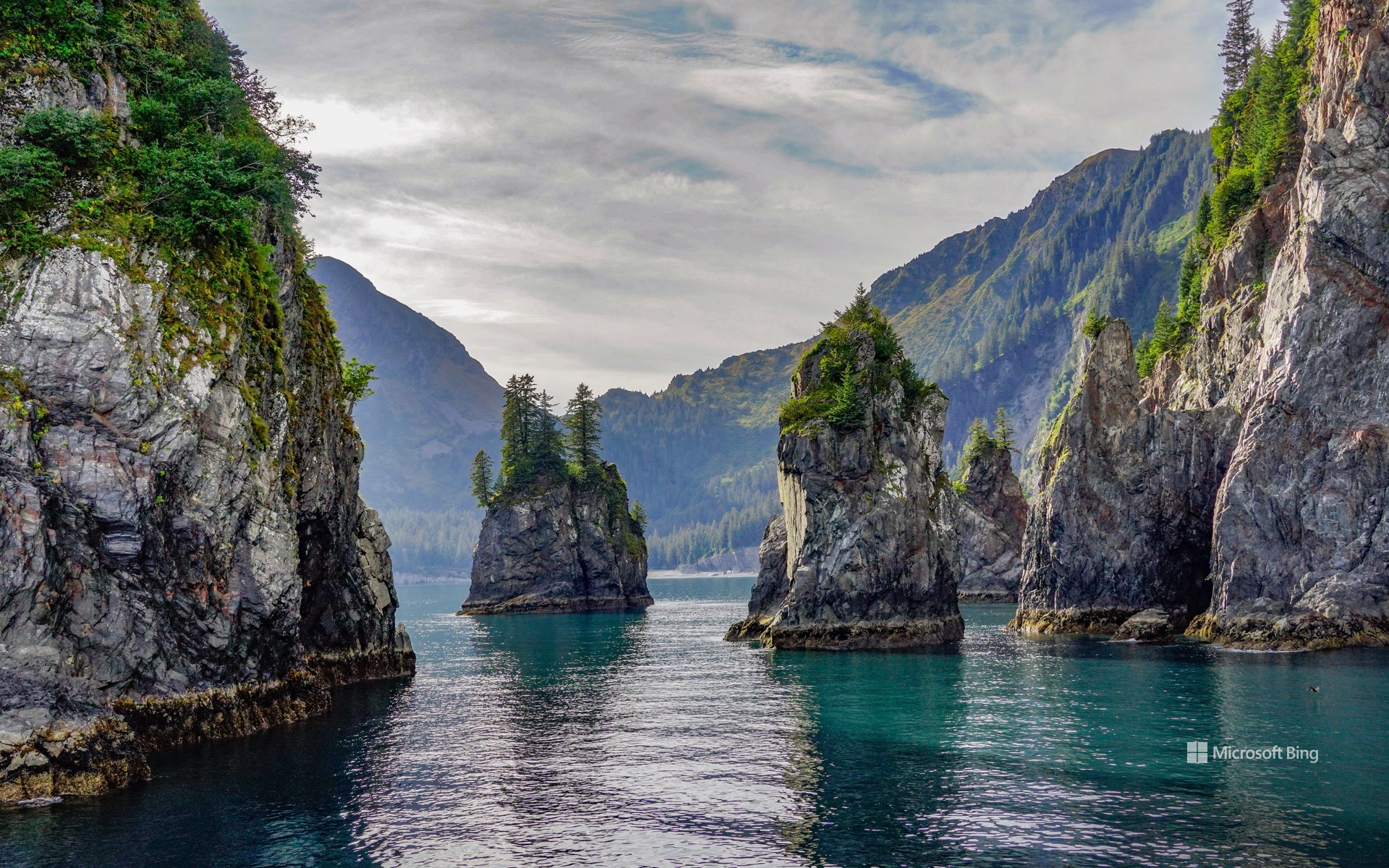
阿拉斯加基奈峡湾国家公园尖顶湾, 阿拉斯加州苏厄德, 美国 Spire Cove in Kenai Fjords National Park, Seward, Alaska, USA (© Wander Photography/Getty Images)
崎岖山峰与野性水域 Rugged peaks and wild waters
阿拉斯加基奈峡湾国家公园尖顶湾, 阿拉斯加州苏厄德
随着国家公园周的持续进行,让我们把目光转向阿拉斯加基奈半岛上的瑰宝——基奈峡湾国家公园。该公园面积超过1,000 平方英里,拥有高耸的峡湾、蜿蜒的河谷和高山地貌。其中超过一半的区域被冰雪覆盖,冰川占据了其面积的 51%。在 20 世纪,公园内的冰川不断消退,为植物和动物的生长腾出了新的土地。从古老的西加云杉到娇嫩的柳兰幼苗,再到覆盖森林地面的茂密苔藓,尽管地势崎岖,基奈峡湾的植物依然繁茂生长。该公园也是多种陆地和海洋哺乳动物的栖息地,包括森林狼、豪猪、加拿大猞猁,以及虎鲸和长须鲸等鲸目动物。这里还栖息着多种鸟类,如白头海雕和皮尔氏游隼。
基奈峡湾国家公园不仅有令人惊叹的自然景观和繁茂的荒野,还蕴藏着丰富的人类历史。几千年来,阿拉斯加原住民在此生活,留下了他们生活的痕迹。在国家公园的范围内,过去依然留下印记,从沿海分布的苏格皮亚克人(阿拉斯加原住民一族)营地,到努卡湾中废弃的旧矿营遗迹。这些历史的足迹和公园的自然奇观一样珍贵,为我们提供了与曾塑造这片土地的人们之间的重要连接。有如此丰富的内容可供探索,难怪基奈峡湾是该州最受欢迎的公园之一。
Spire Cove in Kenai Fjords National Park, Seward, Alaska
As National Park Week rolls on, let's turn our attention to Kenai Fjords National Park, a gem on Alaska's Kenai Peninsula. Stretching over 1,000 square miles, this landscape features fjords, river valleys, and alpine landscapes. More than half of the terrain is blanketed in ice. Throughout the 20th century, the park's glaciers have receded, uncovering new land for plant and animal life to take root. From ancient Sitka spruces to delicate fireweed shoots and moss carpeting the forest floor, plant life in Kenai Fjords flourishes. The park is also home to diverse terrestrial and marine mammals, including timber wolves, porcupines, Canadian lynxes, and cetaceans like orcas and fin whales. It also hosts a variety of birds, such as bald eagles and Peale's peregrine falcons.
Kenai Fjords isn't just about stunning landscapes and flourishing wilderness—it's also a place rich with human history. For thousands of years, Alaska Natives have called this region home, leaving behind traces of their lives in the land. Within the national park, the past still lingers—from the camps left by Alaska Native Sugpiaq people once scattered along the coastline to the remnants of old mining camps in Nuka Bay.
温德河,布鲁克斯山脉,北极国家野生动物保护区,阿拉斯加州,美国 Wind River, Brooks Range, Arctic National Wildlife Refuge, Alaska, USA (© Design Pics/DanitaDelimont)
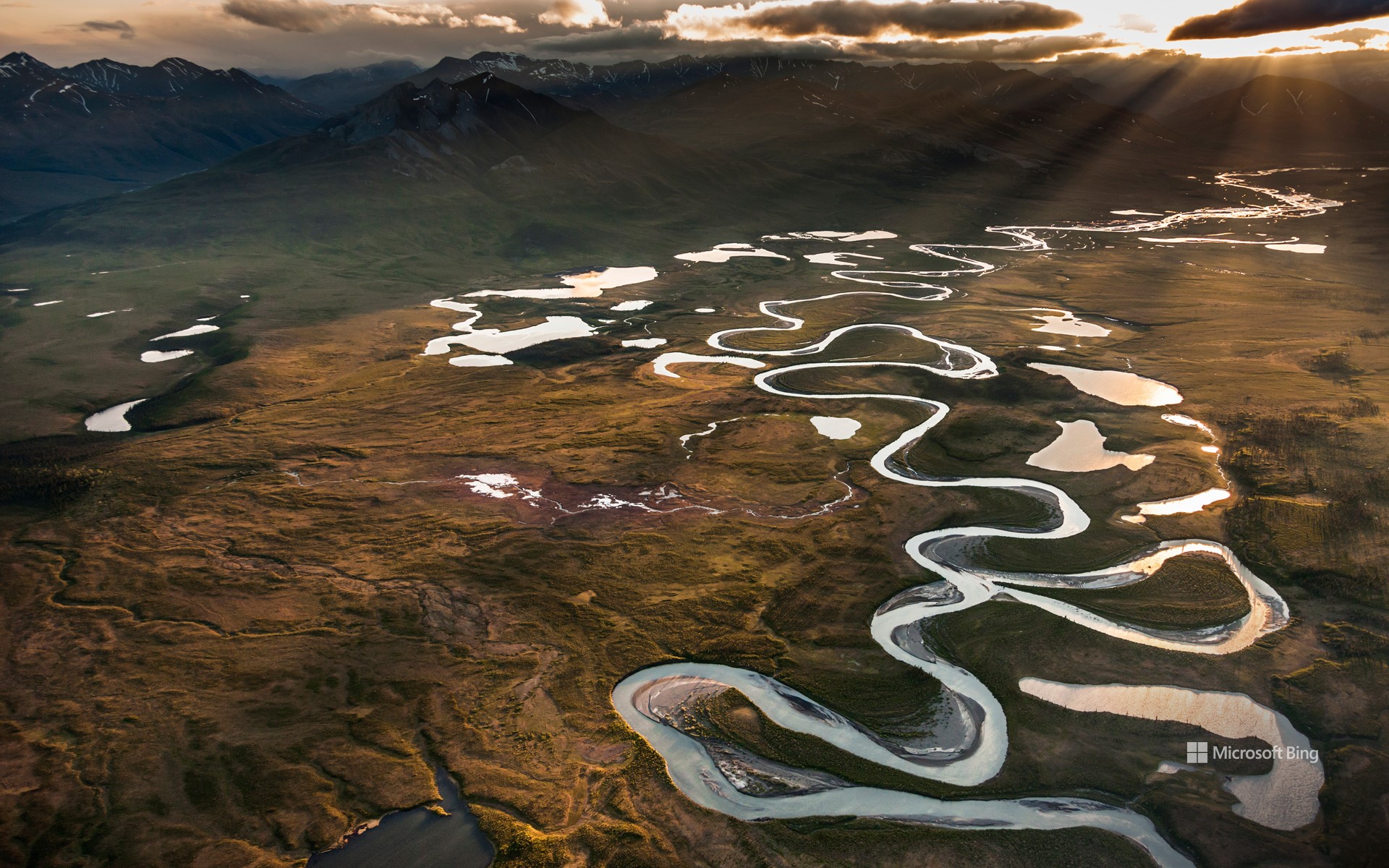
温德河,布鲁克斯山脉,北极国家野生动物保护区,阿拉斯加州,美国 Wind River, Brooks Range, Arctic National Wildlife Refuge, Alaska, USA (© Design Pics/DanitaDelimont)
河流的狂野舞蹈 River's wild dance
温德河,北极国家野生动物保护区,阿拉斯加州
你是否想过美国那些野生河流是如何保持原始状态的?这要归功于《野生与风景河流法案》,它于1968年的今天被签署成为法律。这项立法还创建了国家野生与风景河流系统,旨在保护那些具有杰出的自然、文化以及休闲价值的特定河流,使其保持自由流动的状态。这个国家系统管理着40个州的209条河流,它们的总长超过12700英里,但不到美国350万英里河流的四分之一。在这个系统中,河流被分类为野生、风景或休闲河流。例如今天图片中看到的温德河就是一条野生河流,它尚处于孤立且未被开发的状态。这条85英里长的河流从菲利普·史密斯山脉流向昌达拉河的东支,蜿蜒穿过一个布满湖泊和湿地的河谷。作为北极国家野生动物保护区的一部分,这个河谷是一个繁荣的栖息地,居住着白大角羊、驼鹿、北美驯鹿、灰熊等动物。在这个充满变化的世界里,还有如此原生态的河流,真令人欣慰。
Wild and Scenic Rivers Act
Ever wonder how some of our rivers stay unspoiled? It's thanks to the Wild and Scenic Rivers Act, which was signed into law on this day in 1968. This legislation created the National Wild and Scenic Rivers System, which preserves rivers with exceptional natural, cultural, and recreational qualities.
The national rivers system oversees more than 13,000 miles of 228 rivers across 41 states and Puerto Rico, a tiny fraction of the 3.5 million miles of US rivers. It categorizes rivers as wild, scenic, or recreational. The Wind River in northeastern Alaska, seen in today's image, is a wild river, isolated and undeveloped. It flows for 85 miles, from the Philip Smith Mountains to the East Fork of the Chandalar River, winding through a valley filled with lakes and wetlands. Part of the Arctic National Wildlife Refuge, this river valley is a bustling habitat for Dall sheep, moose, caribou, and grizzly bears. In a changing world, it's comforting to know these rivers will remain unchanged.
复活节溪和基利克河的交汇处,北极之门国家公园,阿拉斯加州,美国 Confluence of Easter Creek and Killik River, Gates of the Arctic National Park, Alaska, USA (© Patrick J. Endres/Getty Images)
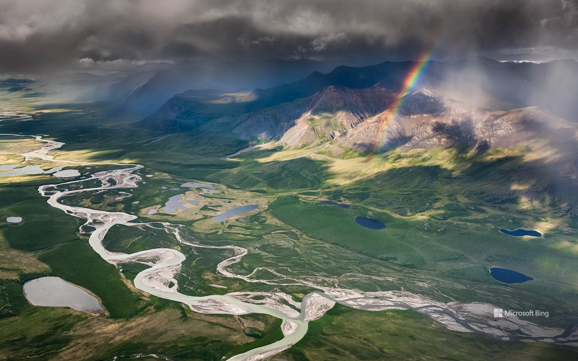
复活节溪和基利克河的交汇处,北极之门国家公园,阿拉斯加州,美国 Confluence of Easter Creek and Killik River, Gates of the Arctic National Park, Alaska, USA (© Patrick J. Endres/Getty Images)
河流的交汇 The meeting of the waters
国家河流月
加拿大活动家马克·安吉洛发起了为期三十天的“国家河流月”活动,向地球脉络致敬。今天的图片展示的是阿拉斯加复活节溪和基利克河的交汇处,真是一幅美丽的画卷啊!和这些溪流一样,人们每年也会聚集在一起,为保护这些河流出力。随着污染、栖息地破坏和过度使用等情况日益加剧,倡导保护河流比以往任何时候都更加重要。无论你是在平缓的溪流中划桨,还是在垂钓时抛下鱼线,抑或只是沿着河岸悠闲地散步,都可以通过无数种方式与这些流动的奇迹建立联系。仅美国就拥有一个由25万多条河流组成的庞大河网,这些河流在不同的地形上绵延300多万英里。你想去参观哪条河呢?
National Rivers Month
The lush greenery of June is here, and so is National Rivers Month, a tribute to the veins of our planet, created by Canadian activist Mark Angelo. Just like the confluence featured here today, where Alaska's Easter Creek and Killik River unite in a beautiful display, we too come together every year to help preserve the nation's rivers. With increasing threats such as pollution, habitat destruction, and overuse, it's more important than ever to advocate for their protection. Whether you're paddling down a gentle stream, casting a fishing line, or simply enjoying a leisurely stroll along the riverbank, there are countless ways to connect with our waterways. The US alone boasts a vast network of over 250,000 rivers, stretching more than 3 million miles. Which one are you heading to?
座头鲸家族,荷兰港,阿拉斯加州, 美国 Family of humpback whales, Dutch Harbor, Alaska, USA (© Jude Newkirk/Amazing Aerial Agency)

座头鲸家族,荷兰港,阿拉斯加州, 美国 Family of humpback whales, Dutch Harbor, Alaska, USA (© Jude Newkirk/Amazing Aerial Agency)
希望的浪潮 Waves of hope
世界海洋日
今天,在庆祝世界海洋日之际,让我们共同踏上一场海洋之旅吧!世界海洋日是为了纪念和保护世界上的海洋,提醒人们海洋在维持地球生命方面所发挥的关键性作用。毕竟,从最小的浮游生物到如图中所示的座头鲸一样巨大的鲸鱼,这些庞大的水体中充满了奇迹。由于浮游生物(微小的植物、藻类和细菌)的光合作用,海洋还产生了地球上近一半的氧气。此外,海洋还从大气中吸收大量的二氧化碳,这有助于减轻人类活动造成的气候变化影响。
海洋面临着许多威胁,包括全球变暖导致的海洋温度上升、塑料污染和海洋酸化,这威胁到许多海洋物种。今年世界海洋日的主题是“新深度唤醒”,这一口号鼓励我们深入探究海洋的复杂性,并积极采取行动,确保这些迷人的海洋动物世世代代继续为我们的星球增添光彩。那么,你准备好加入行动了吗?
World Oceans Day
Today, let's embark on a watery adventure for World Oceans Day, a celebration of the critical role played by oceans in supporting life on Earth. These gargantuan water bodies teem with wonders, from the tiniest plankton to the grandest whales, like the humpbacks we see here. The oceans also produce almost half of the oxygen on our planet thanks to the photosynthesis of plankton—tiny plants, algae, and bacteria. Moreover, they absorb carbon dioxide from the atmosphere, helping mitigate the impacts of climate change.
Oceans, and the marine species they support, face many threats, including rising sea temperatures thanks to global warming, plastic pollution, and ocean acidification. The theme for this year's World Oceans Day is 'Awaken New Depths.' This motto encourages us to delve deeper into the ocean's complexities and ensure that fascinating, ocean-dwelling animals, like our homepage whales, continue to grace our planet for generations to come. Are you ready to take the plunge?
科迪亚克国家野生动物保护区,科迪亚克岛,阿拉斯加州,美国 Kodiak National Wildlife Refuge, Kodiak Island, Alaska (© Ian Shive/Tandem Stills + Motion)

科迪亚克国家野生动物保护区,科迪亚克岛,阿拉斯加州,美国 Kodiak National Wildlife Refuge, Kodiak Island, Alaska (© Ian Shive/Tandem Stills + Motion)
西沃德的财富 Seward's fortune
科迪亚克国家野生动物保护区,阿拉斯加
1867年10月18日,在美国国务卿威廉·亨利·西沃德的谈判下,俄国将阿拉斯加的领土转让给了美国。美国一共花费了720万美元,以每英亩约两美分的价格买下了阿拉斯加地区,这一段历史被称为“阿拉斯加交易”。如今,这一天被称为阿拉斯加日,以纪念阿拉斯加丰富的历史、多元的文化、未开垦的荒野和坚忍不拔的精神。
1941年,在时任美国总统富兰克林·德拉诺·罗斯福的领导下,成立了科迪亚克国家野生动物保护区。位于阿拉斯加的科迪亚克岛的地理风貌复杂多样,不仅有绵延数百英里的海岸线,还有湖泊、湿地、沼泽和草原。岛上山峰高耸,峡湾和茂密的植被点缀其间,莎草、赤杨、云杉、绚烂的野花和美味的浆果随处可见。此外,岛上还有一种以科迪亚克岛的名字命名的野生动物,名叫科迪亚克熊,是棕熊中的最大亚种。
Alaska Day
On October 18, 1867, the Russian Empire transferred the territory of Alaska to the United States following negotiations by US Secretary of State William Seward. The US paid $7.2 million, or about 2 cents per acre, for the land, adding more than 586,0000 square miles to its territory. Today the date is known as Alaska Day and honors the history, untamed wilderness, and unwavering resilience of the state.
To mark the day, we are in the Kodiak National Wildlife Refuge, spread over several islands in the Kodiak Archipelago in southwestern Alaska. Our homepage image shows Kodiak Island, whose landscape includes hundreds of miles of shoreline as well as lakes, marshes, bogs, and meadows. Its towering mountains are home to fjord inlets and lush vegetation, including sedges, alders, spruces, wildflowers, and berries. A wild inhabitant of the islands, the Kodiak bear, the largest subspecies of brown bear, is named after the archipelago.