黑色熔岩海滩鸟瞰图,埃尔戈尔福,兰萨罗特岛,加那利群岛,西班牙 Aerial view of black lava beach, El Golfo, Lanzarote, Canary Islands, Spain (© Westend61/Adobe Stock)
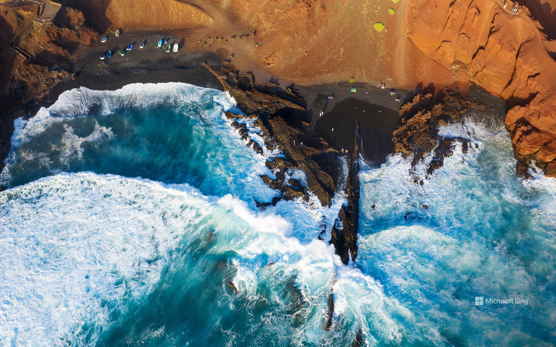
黑色熔岩海滩鸟瞰图,埃尔戈尔福,兰萨罗特岛,加那利群岛,西班牙 Aerial view of black lava beach, El Golfo, Lanzarote, Canary Islands, Spain (© Westend61/Adobe Stock)
黑色熔岩海滩, 加那利群岛,西班牙
在西班牙加那利群岛的兰萨罗特岛,大自然的地质创造力尽情挥洒。赭黄与铁锈色条纹交错的悬崖之下,深色沙滩与大西洋相接,这是延续数百万年的火山活动留下的杰作。这段地质故事中有一章发生在距今并不久远的年代:1730年至1736年间,兰萨罗特岛各处出现了众多火山喷口,熔岩覆盖数十平方英里的土地,掩埋了道路、村庄和农田。
图中的海滩坐落在埃尔戈尔福旁边,这是岛屿西岸的一个小渔村。村庄毗邻洛斯火山自然公园,而船只、海鲜餐厅和拍岸浪涛一如往常,仿佛眼前的景色再平常不过。附近著名的绿色潟湖查尔科德洛斯克利科斯位于一座部分坍塌的火山口内,并通过地下裂隙与大海相连。湖水那令人难以置信的翡翠色部分源于藻类,让碧绿湖水、黑色沙滩与蓝色大海同框,构成一幅色彩鲜明夺目的画面。无需滤镜。埃尔戈尔福自带专属调色盘。
Black lava beach, El Golfo, Lanzarote, Canary Islands, Spain
On Lanzarote, part of Spain's Canary Islands, geology got carried away. Dark sand meets the Atlantic beneath cliffs streaked with ocher and rust, the handiwork of volcanic activity spanning millions of years. One chapter of this story arrived remarkably recently: between 1730 and 1736, numerous vents opened across Lanzarote, sending lava over dozens of square miles and burying roads, villages, and farmland.
The beach in the image sits beside El Golfo, a tiny fishing village on the island's western shore. The settlement borders Los Volcanes Natural Park, while boats, seafood restaurants, and crashing waves carry on as if this scenery were perfectly ordinary. Nearby, the famous green lagoon Charco de los Clicos occupies a partially collapsed volcanic crater linked to the sea through underground fissures. Its improbable emerald color comes partly from algae, bringing green water, black sand, and blue sea into one strikingly vivid frame. No filter required. El Golfo comes with its own color palette.
奥尔韦拉航拍图,安达卢西亚,西班牙 Aerial view of Olvera, Andalusia, Spain (© Marco Bottigelli/Getty Images)

奥尔韦拉航拍图,安达卢西亚,西班牙 Aerial view of Olvera, Andalusia, Spain (© Marco Bottigelli/Getty Images)
俯瞰大地拼图 A patchwork from above
奥尔韦拉航拍图,安达卢西亚,西班牙
你是否想过,安达卢西亚为何是西班牙最著名的地区之一?弗拉门戈、塔帕斯、摩尔式建筑和广阔的橄榄林都功不可没。在那些名城之外,还有奥尔韦拉这样的历史古镇。这座村庄被200多万棵橄榄树环绕,作为战略边境聚落发展而来,并在数百年的变迁中成形。奥尔韦拉城堡依然俯瞰着全镇,下方的化身圣母教堂则主导着天际线。前往拉西利亚文化中心,可以了解奥尔韦拉的中世纪历史与传统。
饿了吗?可以尝尝“gazpacho”冷番茄汤、西班牙著名的“jamón ibérico”伊比利亚火腿,或酥脆的“torta de aceite”橄榄油薄饼。若想散步或骑行欣赏风景,可前往塞拉山绿色之路——一条由旧铁路线改造而成的热门步道。在陡峭的鹅卵石街道上要留心脚下:相机也许端得稳,脚步可未必!正如俗语所说,“poco a poco”——慢慢来。放慢脚步,随意漫步,让奥尔韦拉一点点展现自己。
Aerial view of Olvera, Andalusia, Spain
Ever wondered why Andalusia is one of Spain's best-known regions? Flamenco, tapas, Moorish architecture, and extensive olive groves all play a part. Beyond its famous cities, you'll find historic places like Olvera. Surrounded by more than 2 million olive trees, this village developed as a strategic frontier settlement shaped by centuries of change. The Castle of Olvera still watches over the town, while the Church of Our Lady of the Incarnation dominates the skyline below. Visit La Cilla Cultural Center to discover Olvera's medieval history and traditions.
Hungry? Try 'gazpacho,' a chilled tomato soup; 'jamón ibérico,' Spain's famous cured ham; or the 'torta de aceite,' a crisp olive oil biscuit. For a scenic walk or bike ride, head to the Vía Verde de la Sierra, a former railway line turned popular trail. Watch your step on the steep cobbled streets—your camera might stay steady, but your footing may not! As the saying goes, 'poco a poco'—little by little. Slow down, wander, and let Olvera reveal itself.
泰德天文台上空的英仙座流星,加那利群岛,西班牙 Perseid meteors over Teide Observatory, Tenerife, Spain (© Westend61/Getty Images)

泰德天文台上空的英仙座流星,加那利群岛,西班牙 Perseid meteors over Teide Observatory, Tenerife, Spain (© Westend61/Getty Images)
许个愿吧 Make a wish
西班牙特内里费上空的英仙座流星雨
并非所有夏日传统都发生在地面。有些在数百英里高空上演,每次划过一颗流星。英仙座流星雨每年从7月中旬持续至8月下旬,并在8月12日至13日前后达到峰值。世界大部分地区都能看到它;在黑暗天空下,每小时往往会出现数十颗流星。想象自己抬头仰望,一道接一道亮光划过。数到多少颗时,你会忘记数目?每道亮光都来自斯威夫特-塔特尔彗星散落的碎屑,地球穿过其尘埃带时便形成流星。它们看起来像是从英仙座辐射而出。
今天的图片展示了流星雨掠过西班牙特内里费泰德天文台上空的景象。这处高海拔观测点坐落在约7,840英尺高处。海拔高、空气稀薄且光污染程度低,使这里成为观测夜空的绝佳地点。有些英仙座流星会留下持续数秒的发光尾迹,让观星者有足够时间欣赏这场奇观。那么,今年你准备去哪里观看英仙座流星雨?
Perseid meteor shower over Tenerife, Spain
Not every summer tradition happens on the ground. Some take place hundreds of miles overhead, one meteor at a time. The Perseids return every year from mid-July through late August, reaching their peak around August 12-13. Visible across much of the world, they often produce dozens of meteors per hour under dark skies. Picture yourself looking up. One streak appears after another. How many can you spot before you lose count? Each streak comes from debris shed by Comet Swift-Tuttle as Earth moves through its dust trail. The meteors appear to radiate from the constellation Perseus.
Today's image shows the shower above Teide Observatory in Tenerife, Spain. This high-altitude site sits about 7,840 feet above sea level. Its high elevation, thin air, and low levels of light pollution make it an excellent place to observe the night sky. Some Perseid meteors leave glowing trails that linger for several seconds, giving skywatchers just enough time to appreciate the spectacle. So, where will you watch the Perseids this year?
大教堂海滩,加利西亚,西班牙 Praia das Catedrais, Galicia, Spain (© Tui De Roy/Amazing Aerial Agency/Abobe Stock)

大教堂海滩,加利西亚,西班牙 Praia das Catedrais, Galicia, Spain (© Tui De Roy/Amazing Aerial Agency/Abobe Stock)
加境幽廊 Into Galicia's hidden arches
大教堂海滩,加利西亚,西班牙
在西班牙遥远的西北部,加利西亚与大西洋交汇。漫长的海岸线在海浪的强力冲刷下,形成了由悬崖、内湾和海蚀平台交织而成的地貌。雨水充沛的山丘与密林向海绵延,这种景观带有鲜明的大西洋气候基调,使其在感官上更接近于爱尔兰,而非人们惯常印象中的西班牙南部。
在该地区的北缘,里瓦德奥小镇毗邻阿斯图里亚斯自治区,坐落于比斯开湾的河口与外海交汇处。这里的海岸线从崎岖嶙峋转为超现实的奇观,悬崖之后隐匿着复杂的岩石构造和幽静的海湾。大教堂海滩得名于经年累月的海蚀作用所雕琢出的巨型拱门,其宏伟的轮廓酷似哥特式石质大教堂的高耸建筑风格。
潮落之时是最佳的到访时刻。在有限的时间窗内,裸露的海床会化为一座可供步行的“石头迷宫”——这一瞬息万变的地形会随着潮水的再度涌入而消失,海洋迅速收复沙滩并重塑海岸线的形态。
Praia das Catedrais, Galicia, Spain
In Spain's far northwest, Galicia meets the Atlantic with force—its long coastline carved by waves into cliffs, inlets, and wave-cut platforms. Rain-fed hills and dense forests spill toward the sea, creating a landscape that feels closer to Ireland than southern Spain, with shifting skies and a distinctly Atlantic mood.
On the region's northern edge, the town of Ribadeo sits near the border with Asturias on the Bay of Biscay, where estuaries meet the open ocean. The coastline here shifts from rugged to surreal, with cliffs suddenly giving way to complex rock formations and hidden coves. Praia das Catedrais—'Beach of the Cathedrals'—takes its name from massive arches sculpted by the ocean over time, their shapes resembling the soaring architecture of stone cathedrals.
Visit when the tide drops. For a limited stretch of time, the exposed seabed becomes a walkable maze of stone—an ever-changing terrain that disappears again as the ocean surges back in, quickly reclaiming the sand and reshaping the shoreline.
骑行者,巴德纳斯雷亚莱斯自然公园与生物圈保护区,纳瓦拉,西班牙 Cyclist in Bardenas Reales Natural Park and Biosphere Reserve, Navarra, Spain (© Artur Debat/Getty Images)

骑行者,巴德纳斯雷亚莱斯自然公园与生物圈保护区,纳瓦拉,西班牙 Cyclist in Bardenas Reales Natural Park and Biosphere Reserve, Navarra, Spain (© Artur Debat/Getty Images)
路之所止,行之所启 Where the road stops, the ride begins
世界自行车日
虽然日常的通勤之路或许不像今日画面中那般波澜壮阔,但这并不妨碍我们跨上单车,开始蹬踏。在“世界自行车日”到来之际,联合国向全球发出倡议,邀我们重新审视两轮出行的无限可能——无论是在穿梭于现代都市,还是纵贯于偏远荒原。每年的6月3日,这一由联合国发起的国际纪念日旨在认可自行车作为一种务实的出行方式,在促进公众健康、降低碳排放以及提升交通普惠性方面所发挥的关键作用。
画面中,一位探险者正骑行穿越西班牙纳瓦拉自治区的巴德纳斯雷亚莱斯自然公园。这片生物圈保护区呈现出一种苍凉的荒漠景观,是由风力与流水历经数百万年剥蚀而成。其间纵横交错的蚀余悬崖、台地与干涸河床,使其视觉质感比起西班牙北部,更像是某个遥远的外星天体。作为受保护的联合国教科文组织生物圈保护区,该公园允许在指定路径上进行骑行,为人们提供了一个以人类体能时速、近距离感受这一脆弱生态环境的珍贵契机。
World Bicycle Day
Your average route to work might not resemble the one in today's image, but it shouldn't stop you from pedaling. World Bicycle Day invites us to rethink what's possible on two wheels—whether the ride cuts through city streets or remote terrain. Observed every June 3, the United Nations–backed day recognizes cycling as a practical way to move, supporting health, lowering emissions, and making mobility more accessible.
An adventurer shown here cycles through Bardenas Reales Natural Park and Biosphere Reserve in Navarra, Spain, a stark landscape shaped by wind and water over millions of years. Its maze of eroded cliffs, plateaus, and dry channels feels closer to another planet than northern Spain. Protected as a UNESCO Biosphere Reserve, the park allows cycling on designated routes, offering a rare chance to experience a fragile environment at ground level and human speed.
From daily commutes to places like this, bicycles turn travel into exploration—quiet, efficient, and surprisingly bold.
福门托尔灯塔, 马略卡, 巴利阿里群岛, 西班牙 Formentor Lighthouse, Mallorca, Balearic Islands, Spain (© Allard Schager/Getty Images)

福门托尔灯塔, 马略卡, 巴利阿里群岛, 西班牙 Formentor Lighthouse, Mallorca, Balearic Islands, Spain (© Allard Schager/Getty Images)
马略卡岛的边缘 The edge of Mallorca
福门托尔灯塔, 马略卡, 巴利阿里群岛, 西班牙
在西班牙巴利阿里群岛中马略卡岛(Mallorca)的最北端,福门托尔灯塔(Formentor Lighthouse)巍然屹立于福门托尔角(Cap de Formentor)的陡峭悬崖之上。这处地势开阔的海角常被称为“风之汇聚地”。这座灯塔始建于1863年,并于当年9月30日首次点亮,它高耸于地中海海面近700英尺之上;若要抵达此处,需沿着一条狭窄蜿蜒的盘山公路前行,全程约8英里,起点位于波连萨港(Port de Pollença)。脚下是色泽浅淡的石灰岩——这些岩石由远古海洋生物遗骸历经漫长岁月沉积而成,随后在地壳运动的抬升与风化侵蚀的雕琢下,演化为如今这般气势磅礴的峭壁、海蚀洞穴及天然拱门。正是这种崎岖险峻的地质地貌,造就了该地区那种苍凉壮阔的独特美感与遗世独立的孤寂氛围。想要将这绝美景色尽收眼底吗?不妨沿着半岛上的徒步路线前行,或者挑战一段短促却陡峭的登高之路,攀至阿尔贝库奇瞭望塔(Talaia d'Albercutx)俯瞰全景,随后再继续前往灯塔。攀登途中请留意山坡:那些由早期家养羊群野化而来的野生山羊,正凭借着天生的平衡感,在险峻的岩架之间轻盈自如地跳跃穿梭。
Formentor Lighthouse, Mallorca, Balearic Islands, Spain
At Mallorca's far northern tip, in Spain's Balearic Islands, the Formentor Lighthouse stands on the sheer cliffs of Cap de Formentor. This exposed headland is often called the 'Meeting of the Winds.' Built in 1863 and first lit on September 30 of that year, the lighthouse rises nearly 700 feet above the Mediterranean Sea and is reached by a narrow, switchback road about 8 miles from Port de Pollença. Under your feet is pale limestone—rock formed from ancient marine life and later lifted and carved by erosion into dramatic faces, sea caves, and natural arches. This rugged geology gives rise to the area's stark beauty and sense of isolation. Want to earn the view? Follow one of the peninsula's hiking routes, or tackle the short, steep climb to Talaia d'Albercutx for a watchtower panorama before continuing to the lighthouse. Keep an eye on the slopes: wild goats, descended from early domestic herds, spring across the ledges with effortless balance.
帕帕加约海滩, 兰萨罗特, 加那利群岛, 西班牙 Papagayo Beach, Lanzarote, Canary Islands, Spain (© Gavin Hellier/Getty Images)

帕帕加约海滩, 兰萨罗特, 加那利群岛, 西班牙 Papagayo Beach, Lanzarote, Canary Islands, Spain (© Gavin Hellier/Getty Images)
火山外衣 Volcanic veneer
帕帕加约海滩, 兰萨罗特, 加那利群岛, 西班牙
由火焰孕育而成的海滩很少能如此低调,而帕帕加约海滩正好做到了这一点。我们今天看到的海岸线位于西班牙加那利群岛兰萨罗特岛的南端。热带幻想?更像是火山般的精准。数百万年前,这片土地在海底火山喷发的推动下,逐层由玄武岩和火山灰堆积升起。
约400英尺长的小海湾给人一种亲密的感觉。它坐落在洛斯阿乔奇自然纪念地内,仍然受到保护,并故意保持低调。曾经,这里为在非洲和欧洲之间航行的水手提供庇护。如今,人们可以步行、乘船或沿着著名的颠簸土路到达这里——通过不便实现保护。悬崖环绕着海湾,形成天然的防波堤,使大西洋的海水在这里变得平静而清澈。鱼在光影中闪动,螃蟹在潮间带巡逻,章鱼消失在岩石之间。沙子的温暖金色调来自粉碎的贝壳与火山岩的混合,经过千年潮汐的精炼。帕帕加约的魅力在于其对比:由火山喷发锻造,由侵蚀塑形,并通过克制得以保存。
Papagayo Beach, Lanzarote, Canary Islands, Spain
A beach born from fire rarely does so subtly, yet Papagayo Beach manages exactly that. The shoreline we see today rests on the southern edge of Lanzarote, one of Spain's Canary Islands. Tropical fantasy? More like volcanic precision. Millions of years ago, this land rose in successive layers of basalt and ash thrust upward by submarine eruptions.
About 400 feet long, the cove feels intimate. Nestled within Los Ajaches Natural Monument, it remains protected and deliberately low-key. Once, it sheltered sailors navigating between Africa and Europe. Today, it is reached by foot, boat, or a famously bumpy dirt road—preservation by inconvenience. Cliffs arc around the bay, forming natural breakwaters that temper the Atlantic into calm, clear shallows. Fish flicker through the light, crabs patrol the tidal edges, and octopuses vanish into stone. The sand's warm, golden tone? Pulverized shells mixed with volcanic rock, refined by millennia of tides. Papagayo's power lies in its contrasts: forged by eruption, shaped by erosion, and preserved by restraint.
盛开的桃树, 谢萨, 穆尔西亚, 西班牙 Peach trees in bloom, Cieza, Murcia, Spain (© Juan Maria Coy Vergara/Getty Images)

盛开的桃树, 谢萨, 穆尔西亚, 西班牙 Peach trees in bloom, Cieza, Murcia, Spain (© Juan Maria Coy Vergara/Getty Images)
一个美好的春天 A peachy keen spring
谢萨的桃树,穆尔西亚, 西班牙
在谢萨,春天的到来别具一格。它并非缓缓展开,而是色彩缤纷,绚烂夺目。每年二月至三月,这座位于西班牙穆尔西亚地区的小城便成为“花期”(La Floración)的中心,也就是桃树盛开的季节。短短几天内,超过12000英亩的土地——西班牙最大的城市桃园——便会变成我们今天看到的这片色彩斑斓的海洋。
桃子是切萨镇不可或缺的一部分。这里的农民沿袭古罗马的种植技艺,年复一年地精益求精。他们的辛勤耕耘结出了丰硕的果实?便是远近闻名的切萨桃,这种桃子皮薄如天鹅绒,香气扑鼻,饱含着这片土地的阳光、土壤和历史。
在短短几周的盛花期里,缤纷的色彩和芬芳的气息吸引着游客走进果园,带动了当地市场、农业旅游以及“花卉节”等庆祝活动。随着花朵凋谢,它们留下了丰收的希望,以及一种持续到春天之后的甜蜜。
Peach trees in Cieza, Murcia, Spain
Spring hits differently in Cieza. It doesn't gently unfold—it erupts with color. Between February and March, this small city in Spain's Murcia region is the epicenter of 'La Floración,' the flowering of peach trees. In a matter of days, more than 12,000 acres—Spain's largest municipal peach production—transform into the sea of color we see in today's image.
Peaches are woven into Cieza's identity. Here, farmers build on ancient Roman techniques, refining the craft season after season. The fruit of their effort? The renowned Cieza Peach, a velvet-skinned, fragrant fruit that carries the sun, soil, and history of the land.
For a few intense weeks, color and scent pull visitors into the orchards, fueling local markets, agritourism, and celebrations like the 'Fiesta de la Floración.' As the blossoms fade, they leave behind the promise of harvests to come—and a sweetness that lingers well beyond spring.
伊维萨岛, 巴利阿里群岛, 西班牙 Ibiza, Balearic Islands, Spain (© tokar/Shutterstock)

伊维萨岛, 巴利阿里群岛, 西班牙 Ibiza, Balearic Islands, Spain (© tokar/Shutterstock)
每一步,都是传承 Tradition in every step
伊维萨岛, 巴利阿里群岛, 西班牙
今天,我们一同庆祝西班牙迷人的巴利阿里群岛。巴利阿里群岛日致敬这一片多样却紧密相连的地中海土地——马略卡、梅诺卡、伊维萨与福门特拉,共同构成独特的群岛身份。这个日子同时纪念《巴利阿里自治法》,该法案于1983年3月1日正式生效,确立群岛作为西班牙的一个自治区。
巴利阿里群岛的底色,源于与海相伴的生活方式,也来自音乐、手工艺与热情好客共同孕育的文化传统。这里的自然环境脆弱而珍贵:梅诺卡岛在守护生态的同时保留着真实的岛屿生活;福门特拉岛则珍藏着重要的海洋栖息地;马略卡岛将群山、原野与海岸融为一体,城镇中至今延续着传统工艺与建筑风貌。今日伊维萨岛上空的日落航拍,让人心怀敬意望向远方,也映现出这座岛屿在传统底蕴与当代创造力之间的独特平衡。
这一天旨在倡导尊重文化多样性、践行可持续理念、促进教育发展,确保地中海的文化遗产能够世代相传、生生不息。
埃斯韦德拉岛和埃斯韦德拉内尔岛,伊维萨岛,西班牙 Islets of Es Vedrà and Es Vedranell, Ibiza, Spain (© L. Apolli/Getty Images)

埃斯韦德拉岛和埃斯韦德拉内尔岛,伊维萨岛,西班牙 Islets of Es Vedrà and Es Vedranell, Ibiza, Spain (© L. Apolli/Getty Images)
海妖歌唱之处 Where the Sirens sing
埃斯韦德拉岛和埃斯韦德拉内尔岛,伊维萨岛, 西班牙
在西班牙伊维萨岛西南海域,矗立着两座无人居住的小岛——埃斯韦德拉和埃斯韦德拉内尔。它们属于受保护的自然保留区,以独特的生态价值和震撼的视觉效果闻名。埃斯韦德拉几乎垂直从海中升起,高约1300英尺,陡峭的石灰岩峭壁宛如一座孤立的山脉。不远处的埃斯韦德拉内尔轮廓锋利,因形似伏卧的巨龙而被称为“沉睡的巨龙”,与主岛的高峻挺拔相互映衬。
看似荒凉的礁岛之上,生态却格外丰饶。本土植物在岩缝间生长,海鸟栖息其上,伊维萨壁蜥等特有物种与众多适应峭岩环境的无脊椎动物共同维系着脆弱而精密的生态网络,也因此使这片区域始终处于严格保护之中。
埃斯韦德拉同样笼罩在传说之中,人们常将它比作地中海的百慕大三角,相传这里坐落于神秘的磁场区域,指南针失准、诡异光影的传闻由此而来。在希腊神话中,这座岩岛被视为塞壬女妖的居所,她们曾诱惑奥德修斯;也有人相信,这里是亚特兰蒂斯文明残存的一角。荒凉、野性且神秘,这两座岛屿会在你离开很久之后,仍会悄然浮现在脑海。
Es Vedrà and Es Vedranell, Ibiza, Spain
Just southwest of Ibiza, Spain, lie the uninhabited islets of Es Vedrà and Es Vedranell. Part of a protected nature reserve, these dramatic rock formations are admired for their ecological value and visual impact. Es Vedrà rises around 1,300 feet straight from the sea, its sheer limestone cliffs resembling a mountain range. Nearby, the jagged outline of Es Vedranell has earned it the nickname 'sleeping dragon,' appearing to guard its larger sibling.
Despite their stark appearance, the islets support a surprisingly rich ecosystem, including native flora, marine birds, endemic species such as the Ibiza wall lizard, and numerous invertebrates adapted to the rocky terrain. This fragile biodiversity is one of the reasons public access is tightly restricted.
Es Vedrà is also steeped in legend. Often compared to the Bermuda Triangle, it is said to lie within a powerful magnetic zone, inspiring stories of faulty compasses and strange lights. In Greek mythology, the islet is linked to the Sirens who lured Odysseus, while others believe it to be a remnant of the lost city of Atlantis. Wild and enigmatic, Es Vedrà and Es Vedranell are the kind of places that stay with you long after you've left.