黑色熔岩海滩鸟瞰图,埃尔戈尔福,兰萨罗特岛,加那利群岛,西班牙 Aerial view of black lava beach, El Golfo, Lanzarote, Canary Islands, Spain (© Westend61/Adobe Stock)
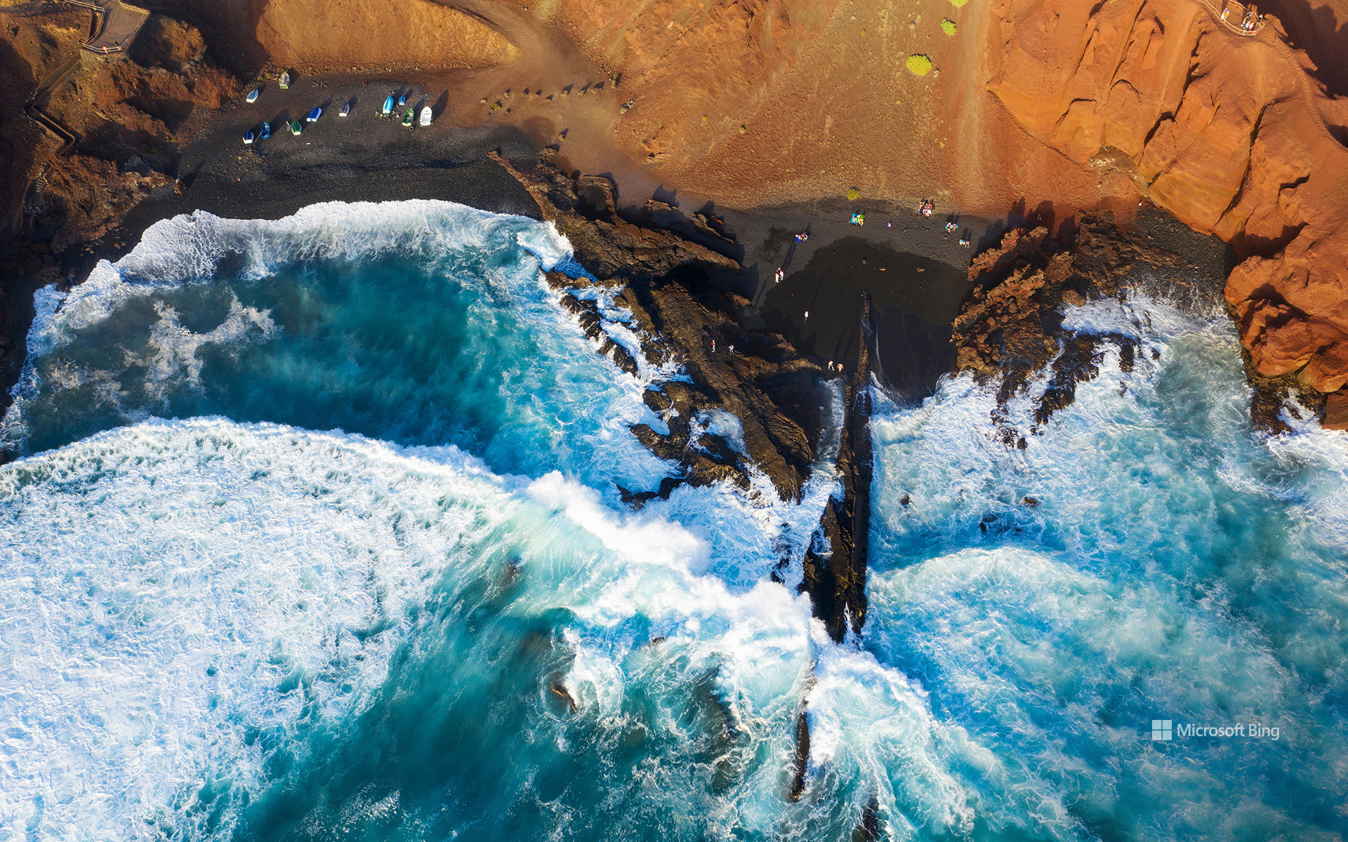
黑色熔岩海滩鸟瞰图,埃尔戈尔福,兰萨罗特岛,加那利群岛,西班牙 Aerial view of black lava beach, El Golfo, Lanzarote, Canary Islands, Spain (© Westend61/Adobe Stock)
黑色熔岩海滩, 加那利群岛,西班牙
在西班牙加那利群岛的兰萨罗特岛,大自然的地质创造力尽情挥洒。赭黄与铁锈色条纹交错的悬崖之下,深色沙滩与大西洋相接,这是延续数百万年的火山活动留下的杰作。这段地质故事中有一章发生在距今并不久远的年代:1730年至1736年间,兰萨罗特岛各处出现了众多火山喷口,熔岩覆盖数十平方英里的土地,掩埋了道路、村庄和农田。
图中的海滩坐落在埃尔戈尔福旁边,这是岛屿西岸的一个小渔村。村庄毗邻洛斯火山自然公园,而船只、海鲜餐厅和拍岸浪涛一如往常,仿佛眼前的景色再平常不过。附近著名的绿色潟湖查尔科德洛斯克利科斯位于一座部分坍塌的火山口内,并通过地下裂隙与大海相连。湖水那令人难以置信的翡翠色部分源于藻类,让碧绿湖水、黑色沙滩与蓝色大海同框,构成一幅色彩鲜明夺目的画面。无需滤镜。埃尔戈尔福自带专属调色盘。
Black lava beach, El Golfo, Lanzarote, Canary Islands, Spain
On Lanzarote, part of Spain's Canary Islands, geology got carried away. Dark sand meets the Atlantic beneath cliffs streaked with ocher and rust, the handiwork of volcanic activity spanning millions of years. One chapter of this story arrived remarkably recently: between 1730 and 1736, numerous vents opened across Lanzarote, sending lava over dozens of square miles and burying roads, villages, and farmland.
The beach in the image sits beside El Golfo, a tiny fishing village on the island's western shore. The settlement borders Los Volcanes Natural Park, while boats, seafood restaurants, and crashing waves carry on as if this scenery were perfectly ordinary. Nearby, the famous green lagoon Charco de los Clicos occupies a partially collapsed volcanic crater linked to the sea through underground fissures. Its improbable emerald color comes partly from algae, bringing green water, black sand, and blue sea into one strikingly vivid frame. No filter required. El Golfo comes with its own color palette.
安科拉附近的加比特凯尼海滩,卡纳塔克邦,印度 Gabit Keni Beach near Ankola, Karnataka, India (© Amith Nag Photography/Getty Images)
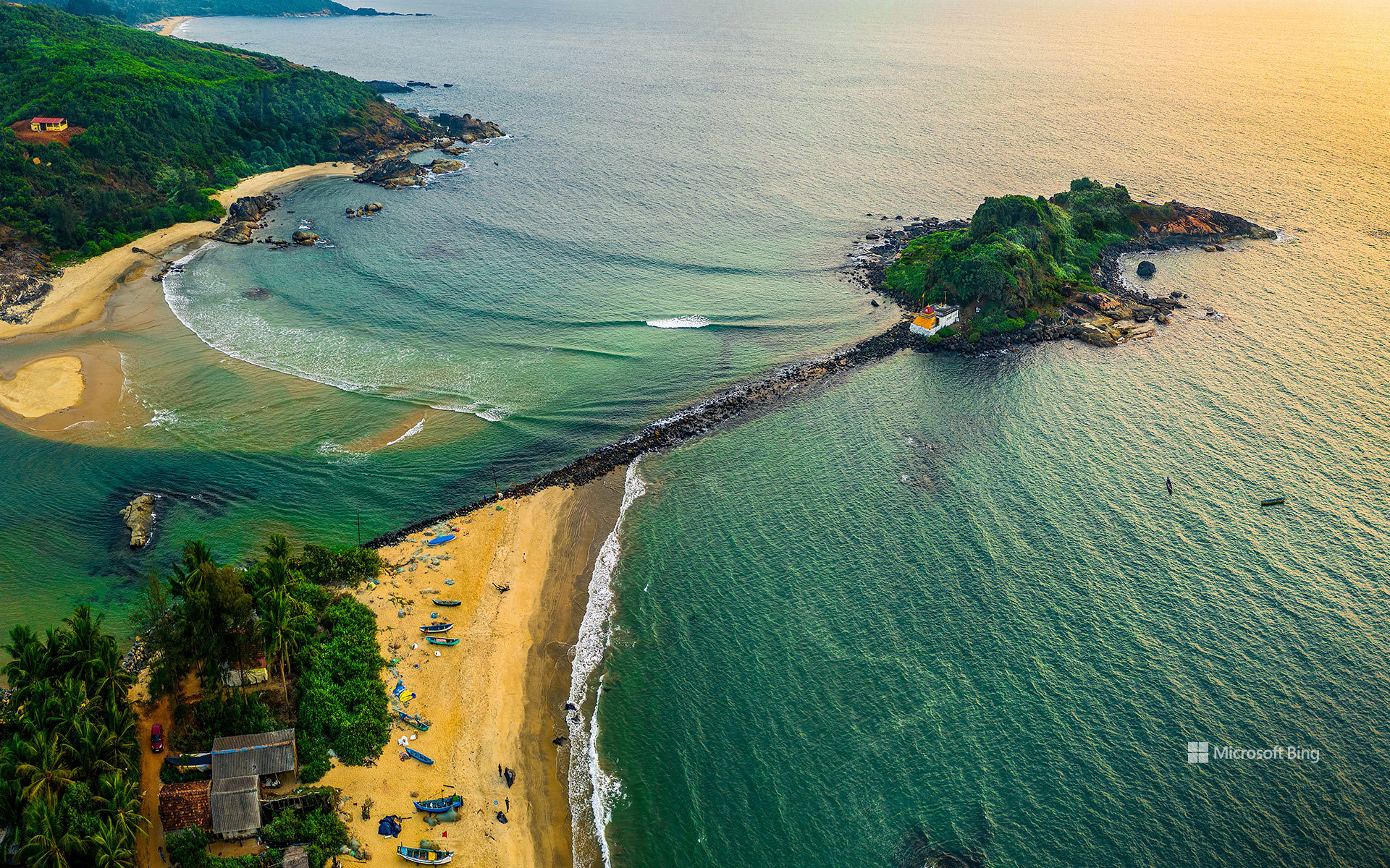
安科拉附近的加比特凯尼海滩,卡纳塔克邦,印度 Gabit Keni Beach near Ankola, Karnataka, India (© Amith Nag Photography/Getty Images)
印度西海岸的生活 Life on India's west coast
安科拉附近的加比特凯尼海滩,卡纳塔克邦,印度
提到印度南部,人们常会想到香料贸易路线、古典音乐、民间舞蹈,以及数百年来连接印度与世界的海岸线。沿着这条海岸向西进入卡纳塔克邦,便会抵达安科拉附近一处更宁静的停靠点:加比特凯尼海滩。这里的生活围绕阿拉伯海展开,渔船在黎明前出海,载着当天的渔获归来。
这片海滩以加比特渔民社区命名。探索北卡纳达县时,这里是个轻松顺路的停靠点,尤其适合与戈卡尔纳、卡尔瓦尔和历史悠久的米尔詹堡一同游览。观鸟者可能在溪流附近看到海岸鸟类,摄影者则常在清晨光线更柔和时驻足。何不尝尝当地美食?安科拉周边餐馆里,新鲜鱼咖喱、炸鱿鱼和鲜虾菜肴都很受欢迎。离开之前,不妨留出时间享用一顿新鲜海鲜;它或许会和这片海滩一样令人难忘。
Gabit Keni Beach near Ankola, Karnataka, India
When people think of South India, they often picture spice trade routes, classical music, folk dances, and a coastline that has connected India with the world for centuries. Follow that coastline west into Karnataka and you'll reach a quieter stop near Ankola: Gabit Keni Beach. Life here revolves around the Arabian Sea, with fishing boats setting out before dawn and returning with the day's catch.
The beach is named after the Gabit fishing community. It's an easy stop while exploring the Uttara Kannada district, especially alongside Gokarna, Karwar, and the historic Mirjan Fort. Birdwatchers may spot coastal birds near the stream, while photographers often stop by during the softer light of early morning. Why not sample local cuisine? Fresh fish curries, squid fry, and prawn dishes are popular at eateries around Ankola. Before you leave, make time for a fresh seafood meal—it may end up being as memorable as the beach itself.
怀特克利夫公园,西温哥华,加拿大 Whytecliff Park, West Vancouver, Canada (© Aolin Chen/Getty Images)

怀特克利夫公园,西温哥华,加拿大 Whytecliff Park, West Vancouver, Canada (© Aolin Chen/Getty Images)
浪潮间的通道 A path between the waves
怀特克利夫公园,西温哥华,加拿大
通往此处的最佳路径并非由混凝土铺就。每当退潮时,一条岩石小径便会显露出来,连接着加拿大西温哥华的怀特克利夫公园(Whytecliff Park)与怀特小岛(Whyte Islet)。数小时后,海水会悄然漫过这条通道,将“把握时机”也变成了体验的一部分。这片海岸线吸引着一代又一代的游客:潮汐开辟了道路,而湿滑的岩石则让人心存敬畏;作为回报,你将收获回望海滩与格伦伊格尔斯(Gleneagles)山坡民居时的壮丽景致。
怀特克利夫公园(Whytecliff Park)得名于曾矗立在这段海岸线上的浅色悬崖;1993年,其周边海域成为加拿大首个咸水海洋保护区,从而在历史上留下了浓墨重彩的一笔。如今,这片海域栖息着200多种海洋生物,使该公园成为水肺潜水爱好者和野生动物观察者的热门去处。人们常能看到港海豹在近岸处出没,甚至还有虎鲸曾在此海域现身。游览完公园后,游客还可以前往灯塔公园(Lighthouse Park)探索一番,或是徒步前往赛普拉斯瀑布公园(Cypress Falls Park)欣赏瀑布美景,为一天的行程画上圆满句号。
大教堂海滩,加利西亚,西班牙 Praia das Catedrais, Galicia, Spain (© Tui De Roy/Amazing Aerial Agency/Abobe Stock)

大教堂海滩,加利西亚,西班牙 Praia das Catedrais, Galicia, Spain (© Tui De Roy/Amazing Aerial Agency/Abobe Stock)
加境幽廊 Into Galicia's hidden arches
大教堂海滩,加利西亚,西班牙
在西班牙遥远的西北部,加利西亚与大西洋交汇。漫长的海岸线在海浪的强力冲刷下,形成了由悬崖、内湾和海蚀平台交织而成的地貌。雨水充沛的山丘与密林向海绵延,这种景观带有鲜明的大西洋气候基调,使其在感官上更接近于爱尔兰,而非人们惯常印象中的西班牙南部。
在该地区的北缘,里瓦德奥小镇毗邻阿斯图里亚斯自治区,坐落于比斯开湾的河口与外海交汇处。这里的海岸线从崎岖嶙峋转为超现实的奇观,悬崖之后隐匿着复杂的岩石构造和幽静的海湾。大教堂海滩得名于经年累月的海蚀作用所雕琢出的巨型拱门,其宏伟的轮廓酷似哥特式石质大教堂的高耸建筑风格。
潮落之时是最佳的到访时刻。在有限的时间窗内,裸露的海床会化为一座可供步行的“石头迷宫”——这一瞬息万变的地形会随着潮水的再度涌入而消失,海洋迅速收复沙滩并重塑海岸线的形态。
Praia das Catedrais, Galicia, Spain
In Spain's far northwest, Galicia meets the Atlantic with force—its long coastline carved by waves into cliffs, inlets, and wave-cut platforms. Rain-fed hills and dense forests spill toward the sea, creating a landscape that feels closer to Ireland than southern Spain, with shifting skies and a distinctly Atlantic mood.
On the region's northern edge, the town of Ribadeo sits near the border with Asturias on the Bay of Biscay, where estuaries meet the open ocean. The coastline here shifts from rugged to surreal, with cliffs suddenly giving way to complex rock formations and hidden coves. Praia das Catedrais—'Beach of the Cathedrals'—takes its name from massive arches sculpted by the ocean over time, their shapes resembling the soaring architecture of stone cathedrals.
Visit when the tide drops. For a limited stretch of time, the exposed seabed becomes a walkable maze of stone—an ever-changing terrain that disappears again as the ocean surges back in, quickly reclaiming the sand and reshaping the shoreline.
珊瑚礁与海滩在拉贾安帕特,印度尼西亚 Coral reef and beach in Raja Ampat, Indonesia (© SergeUWPhoto/Shutterstock)

珊瑚礁与海滩在拉贾安帕特,印度尼西亚 Coral reef and beach in Raja Ampat, Indonesia (© SergeUWPhoto/Shutterstock)
细微之举,影响深远 Small footprint, big impact
珊瑚礁意识周
想象一座由动物建造的城市,在阳光下熠熠生辉,并在海浪之下涌动着生命。这就是珊瑚礁。在珊瑚礁意识周(Coral Reef Awareness Week)期间,我们赞美这些非凡的生态系统,以及依赖其生存的无数物种
珊瑚礁仅覆盖了全球不足1%的海床面积,却支撑着约25%的海洋生命。这些看似彩色岩石的物体,实际上是被称为珊瑚虫(Coral polyps)的微小动物集群。它们共同构建了宏大的石灰岩结构,且能延续数千年之久。大堡礁是地球上最大的生物结构,沿着澳大利亚海岸延伸超过1,400英里。
珊瑚礁充满了惊喜。部分珊瑚因含有能起到天然防晒作用的荧光蛋白而发光;而鹦嘴鱼则通过将珊瑚转化为细砂,协助形成了沙滩。若想一窥珊瑚礁生命最丰富的一面,请看向图中所示的印度尼西亚拉贾安帕特(Raja Ampat),那里生长着超过75%的已知珊瑚物种。它们虽栖息于水下,但其影响力远播至海岸线之外。
Coral Reef Awareness Week
Imagine a city built by animals, glowing in the sunlight, and bustling with life beneath the waves. That is a coral reef. During Coral Reef Awareness Week, we celebrate these remarkable ecosystems and the countless species that depend on them.
Coral reefs cover less than 1% of the ocean floor, yet they support roughly 25% of all marine life. What look like colorful rocks are actually colonies of tiny animals called coral polyps. Together, they build vast limestone structures that can last for thousands of years. The Great Barrier Reef is the largest living structure on Earth, stretching more than 1,400 miles along Australia's coast.
Reefs are full of surprises. Some corals glow thanks to fluorescent proteins that act like natural sunscreen, while parrotfish help create sandy beaches by turning coral into fine sand. For a glimpse of reef life at its richest, look to Raja Ampat in Indonesia, pictured here, where more than 75% of known coral species thrive. They may live underwater, but their impact reaches far beyond the shore.
瓦伊海滩上的日光浴躺椅,克里特岛,希腊 Sunbeds on the beach at Vai, Crete, Greece (© borchee/Getty Images)

瓦伊海滩上的日光浴躺椅,克里特岛,希腊 Sunbeds on the beach at Vai, Crete, Greece (© borchee/Getty Images)
希腊式的逃离 A Greek escape
瓦伊,克里特岛,希腊
在克里特岛的东北角,坐落着一个远离游客喧嚣的静谧之地瓦伊。这片区域的核心景观是其海滩:金黄色的沙滩沿着平静的爱琴海浅水缓缓展开,设有躺椅、遮阳伞与淋浴设施,为游泳、放松或安静休憩提供理想场所。瓦伊最引人注目的特色在于其沙滩背后有着欧洲最大的天然棕榈林。该棕榈林由5000多棵克里特枣椰树构成,这是一种仅分布于克里特岛及土耳其部分地区的特有树种。
20世纪70年代初,瓦伊被一群嬉皮士“重新发现”。他们在被驱离马塔拉村后,将瓦伊作为避世之地。然而,随着1980年代游客数量骤增、基础设施缺乏,瓦伊的环境一度遭受严重破坏。鉴于其独特的生态与文化价值,当局将瓦伊划为保护区。经过多年管理与恢复,如今的瓦伊不仅是克里特岛最原始、最美丽的自然瑰宝之一,也成为负责任旅游与生态保护的典范。这片海滩的复苏,清晰展现了可持续管理对自然环境所能产生的积极影响。
Vai, Crete, Greece
On the remote northeastern tip of the island of Crete in Greece lies Vai—a quiet corner far from the usual tourist trail. At the heart of this region is its beach, a broad curve of golden sand kissed by the calm, shallow waters of the Aegean. With sunbeds, umbrellas, and showers, it's an ideal spot for swimming, relaxing, or simply soaking in the peaceful atmosphere. But what truly sets Vai apart lies just behind the sand: Europe's largest natural palm grove. It is made up of over 5,000 Cretan date palm trees, a species unique to Crete and parts of Türkiye.
In the early 1970s, Vai was 'rediscovered' by hippies, who made it their haven after being moved out of the village of Matala. By the 1980s, however, increasing numbers of visitors and a lack of infrastructure had left the area littered and degraded. Recognizing its ecological and cultural value, authorities declared Vai a protected zone. Cleanup efforts restored the area, and today, Vai is one of Crete's most beautiful and unspoiled natural treasures. It's a reminder of how careful stewardship can bring a place back to life.
博尼亚德海滩上的漂流木, 亨廷岛, 南卡罗来纳州, 美国 Driftwood on Boneyard Beach, Hunting Island, South Carolina, USA (© Frances/Adobe Stock)

博尼亚德海滩上的漂流木, 亨廷岛, 南卡罗来纳州, 美国 Driftwood on Boneyard Beach, Hunting Island, South Carolina, USA (© Frances/Adobe Stock)
逐渐失去立足之地的树木 The trees that lost ground
博尼亚德海滩上的漂流木, 亨廷岛, 南卡罗来纳州
在美国南卡罗来纳州亨廷岛州立公园内的博尼亚德海滩,最先映入眼帘的是那些树木。紧接着,一个疑问便会浮现:为何一根根被海水漂白的树干和裸露的树根散落在沙滩上,仿佛一幕正在坍塌的景象被按下了暂停键?自20世纪80年代以来,亨廷岛一直面临严重的海滩侵蚀问题,其侵蚀速率位居美国东海岸前列。在部分区域,海岸线每年后退幅度最高可达约30英尺(约9米)。
在岛屿南端的博尼亚德海滩上,这一自然演变过程清晰可见:饱经风霜的浮木,以及活橡树和棕榈树的残骸,沿岸错落分布。这些树木曾是滨海森林的一部分,但随着海岸侵蚀和风暴导致海岸线变迁,它们的生存空间逐渐丧失。如今留下的景象,既像是一堂生动的地质课,又宛如一座露天画廊。这里记录了超过200种鸟类;近海常有宽吻海豚出没,附近的沙滩上也有红海龟筑巢产卵。每逢退潮,最宽阔的滩涂便显露出来,供人探索;每一次造访,这里的景致都各不相同,独具风貌。
Driftwood on Boneyard Beach, Hunting Island, South Carolina
At Boneyard Beach within Hunting Island State Park, South Carolina, the first thing you notice is the trees. Then comes the question: why are bleached trunks and exposed roots scattered across the sand like a scene paused midway through collapse? Since the 1980s, Hunting Island has experienced major beach erosion, with some of the highest rates along the US East Coast—reaching up to 30 feet per year in certain areas.
On the island's southern end, Boneyard Beach shows this process clearly: weathered driftwood and the remains of live oaks and palmettos line the shore. Once part of a maritime forest, these trees gradually lost ground as coastal erosion and storms shifted the shoreline. What remains is part geology lesson, part outdoor gallery. More than 200 bird species have been recorded here; bottlenose dolphins are often seen offshore, and loggerhead sea turtles nest on nearby beaches. At low tide, the widest stretch opens to explore, and no two visits look exactly the same.
退潮时裸露在乌尔萨海滩海岸上的帽贝, 葡萄牙 Limpets exposed at low tide on the coast of Praia da Ursa, Portugal (© Theo Bosboom/Nature Picture Library)

退潮时裸露在乌尔萨海滩海岸上的帽贝, 葡萄牙 Limpets exposed at low tide on the coast of Praia da Ursa, Portugal (© Theo Bosboom/Nature Picture Library)
沉静的力量 Quiet strength
退潮时裸露在乌尔萨海滩海岸上的帽贝, 葡萄牙
乌尔萨海滩(Praia da Ursa)深藏在欧洲大陆最西端——罗卡角(Cabo da Roca)附近的陡峭悬崖之下,置身其中,仿佛来到了大陆的尽头。沿着一条狭窄崎岖的小径便可抵达这片隐秘的沙滩。在葡萄牙的大西洋沿岸,风、岩石与惊涛骇浪共同塑造了这里的地貌。当潮水退去,海岸线短暂地变得宽阔,平滑的岩石显露出来,随之而来的还有微小的生命迹象。帽贝紧紧贴在裸露的岩石上,在海浪平日拍打的地方顽强地驻守。
这些其貌不扬的海螺已完全适应了此地的环境:它们凭借强劲的吸附力与低矮的螺壳,从容抵御着海浪的冲击、气温的骤变以及长时间的离水曝晒。每逢涨潮或被海水淹没之时,它们便以海藻为食;待潮水退去,又会回到各自熟悉的栖息之地。乌尔萨海滩(Praia da Ursa)地处偏僻,正因如此,这些细微的瞬间往往容易被游人忽略,而一旦留心察觉,便会倍感惊喜与充实。在这片以宏大尺度与磅礴力量为主调的海岸景观中,哪怕是最微小的幸存者,亦折射出了大西洋海岸那份宁静而坚韧的生命力。
Limpets at low tide on the coast of Praia da Ursa, Portugal
Tucked away beneath steep cliffs near Cabo da Roca, the westernmost point of mainland Europe, Praia da Ursa feels like the edge of the continent. Reached by a narrow, rugged trail, this secluded beach along Portugal's Atlantic coast is shaped largely by wind, stone, and powerful waves. When the tide recedes, the shoreline briefly widens. Smooth rocks emerge, and with them, small signs of life. Limpets cling tightly to the exposed stone, holding fast where the ocean usually breaks.
These modest marine snails are well adapted to conditions here, using strong suction and low shells to withstand surf, shifting temperatures, and long periods exposed to air. During high tide or when submerged, they graze on algae, then return to familiar spots as the sea recedes. Praia da Ursa's isolation makes these moments easy to miss and rewarding to notice. In a landscape defined by scale and force, even the smallest survivors reflect the Atlantic coast's quiet resilience.
镜面海滩,塞古罗港,巴伊亚州,巴西 Espelho Beach, Trancoso, Bahia, Brazil (© Marcelo Nacinovic/Getty Images)

镜面海滩,塞古罗港,巴伊亚州,巴西 Espelho Beach, Trancoso, Bahia, Brazil (© Marcelo Nacinovic/Getty Images)
潮汐留下的印记 The tide's passing signature
巴西巴伊亚州塞古罗港 · 镜面海滩
从空中俯瞰,巴西的镜面海滩宛如一幅可以走入其中的水彩画。浅色的悬崖、点缀在海岸线上的礁石,以及由潮汐形成的片片水潭,在退潮时清晰映出天空与云朵,也正因如此,这片海滩得名“镜面海滩”。它位于巴西东北部大西洋沿岸的巴伊亚州,坐落在塞古罗港的几座小渔村之间。通往这里需要经过土路和短途步道,这种相对不便的交通反而成为一种“天然限流”,让海滩始终保持着宁静而私密的氛围。它位于巴西东北部大西洋沿岸的巴伊亚州,坐落在塞古罗港的几座小渔村之间。通往这里需要经过土路和短途步道,这种相对不便的交通反而成为一种“天然限流”,让海滩始终保持着宁静而私密的氛围。
最迷人的地方在于,这里的景观从不一成不变,而是始终与海洋进行着动态的“对话”。每一次潮汐都会重新勾勒沙洲的轮廓,显露出珊瑚结构,并为水潭补充新的“小居民”——鱼类、海星以及各种微小的海洋生物。最迷人的地方在于,这里的景观从不一成不变,而是始终与海洋进行着动态的“对话”。每一次潮汐都会重新勾勒沙洲的轮廓,显露出珊瑚结构,并为水潭补充新的“小居民”——鱼类、海星以及各种微小的海洋生物。
帕帕加约海滩, 兰萨罗特, 加那利群岛, 西班牙 Papagayo Beach, Lanzarote, Canary Islands, Spain (© Gavin Hellier/Getty Images)

帕帕加约海滩, 兰萨罗特, 加那利群岛, 西班牙 Papagayo Beach, Lanzarote, Canary Islands, Spain (© Gavin Hellier/Getty Images)
火山外衣 Volcanic veneer
帕帕加约海滩, 兰萨罗特, 加那利群岛, 西班牙
由火焰孕育而成的海滩很少能如此低调,而帕帕加约海滩正好做到了这一点。我们今天看到的海岸线位于西班牙加那利群岛兰萨罗特岛的南端。热带幻想?更像是火山般的精准。数百万年前,这片土地在海底火山喷发的推动下,逐层由玄武岩和火山灰堆积升起。
约400英尺长的小海湾给人一种亲密的感觉。它坐落在洛斯阿乔奇自然纪念地内,仍然受到保护,并故意保持低调。曾经,这里为在非洲和欧洲之间航行的水手提供庇护。如今,人们可以步行、乘船或沿着著名的颠簸土路到达这里——通过不便实现保护。悬崖环绕着海湾,形成天然的防波堤,使大西洋的海水在这里变得平静而清澈。鱼在光影中闪动,螃蟹在潮间带巡逻,章鱼消失在岩石之间。沙子的温暖金色调来自粉碎的贝壳与火山岩的混合,经过千年潮汐的精炼。帕帕加约的魅力在于其对比:由火山喷发锻造,由侵蚀塑形,并通过克制得以保存。
Papagayo Beach, Lanzarote, Canary Islands, Spain
A beach born from fire rarely does so subtly, yet Papagayo Beach manages exactly that. The shoreline we see today rests on the southern edge of Lanzarote, one of Spain's Canary Islands. Tropical fantasy? More like volcanic precision. Millions of years ago, this land rose in successive layers of basalt and ash thrust upward by submarine eruptions.
About 400 feet long, the cove feels intimate. Nestled within Los Ajaches Natural Monument, it remains protected and deliberately low-key. Once, it sheltered sailors navigating between Africa and Europe. Today, it is reached by foot, boat, or a famously bumpy dirt road—preservation by inconvenience. Cliffs arc around the bay, forming natural breakwaters that temper the Atlantic into calm, clear shallows. Fish flicker through the light, crabs patrol the tidal edges, and octopuses vanish into stone. The sand's warm, golden tone? Pulverized shells mixed with volcanic rock, refined by millennia of tides. Papagayo's power lies in its contrasts: forged by eruption, shaped by erosion, and preserved by restraint.