怀特克利夫公园,西温哥华,加拿大 Whytecliff Park, West Vancouver, Canada (© Aolin Chen/Getty Images)

怀特克利夫公园,西温哥华,加拿大 Whytecliff Park, West Vancouver, Canada (© Aolin Chen/Getty Images)
浪潮间的通道 A path between the waves
怀特克利夫公园,西温哥华,加拿大
通往此处的最佳路径并非由混凝土铺就。每当退潮时,一条岩石小径便会显露出来,连接着加拿大西温哥华的怀特克利夫公园(Whytecliff Park)与怀特小岛(Whyte Islet)。数小时后,海水会悄然漫过这条通道,将“把握时机”也变成了体验的一部分。这片海岸线吸引着一代又一代的游客:潮汐开辟了道路,而湿滑的岩石则让人心存敬畏;作为回报,你将收获回望海滩与格伦伊格尔斯(Gleneagles)山坡民居时的壮丽景致。
怀特克利夫公园(Whytecliff Park)得名于曾矗立在这段海岸线上的浅色悬崖;1993年,其周边海域成为加拿大首个咸水海洋保护区,从而在历史上留下了浓墨重彩的一笔。如今,这片海域栖息着200多种海洋生物,使该公园成为水肺潜水爱好者和野生动物观察者的热门去处。人们常能看到港海豹在近岸处出没,甚至还有虎鲸曾在此海域现身。游览完公园后,游客还可以前往灯塔公园(Lighthouse Park)探索一番,或是徒步前往赛普拉斯瀑布公园(Cypress Falls Park)欣赏瀑布美景,为一天的行程画上圆满句号。
地牢省立公园, 纽芬兰和拉布拉多省, 加拿大 Dungeon Provincial Park, Newfoundland and Labrador, Canada (© Kaitlyn McLachlan/Getty Images)

地牢省立公园, 纽芬兰和拉布拉多省, 加拿大 Dungeon Provincial Park, Newfoundland and Labrador, Canada (© Kaitlyn McLachlan/Getty Images)
大西洋雕琢而成的加拿大 Canada, carved by the Atlantic
地牢省立公园,加拿大
位于纽芬兰岛博纳维斯塔半岛的地牢省立公园,长期受到大西洋海浪的塑造与侵蚀。公园最著名的景观“地牢(Dungeon)”实际上是一处巨大的塌陷海蚀洞,其顶部因持续侵蚀而坍塌,形成直通天空的壮观开口。这一地貌生动展示了海洋作用如何在数千年间不断改造坚硬岩石。
公园周围的悬崖主要由数亿年前形成的沉积岩构成。砂岩与页岩层记录着远古环境演变的痕迹,其形成时间甚至早于现代大西洋的出现。如今,海鸟、滨海植物以及沿岸洋流共同维系着这片充满活力的海岸生态系统,并持续影响着当地自然环境的发展。
地牢省立公园所在海岸位于西北大西洋重要的海鸟迁徙通道上。每年较温暖的季节,游客有机会看到三趾鸥、海鸠以及北方塘鹅等海鸟在悬崖与海面之间翱翔。丰富的海洋营养物质与崎岖的海岸环境共同构成了理想栖息地,使这里成为众多海洋生物的重要庇护所.
Canada Day
On July 1, Canada celebrates its national day, marking the events of 1867, when the British North America Act (now called the Constitution Act, 1867) united three British colonies into one Dominion.
In 1879, July 1 became a federal holiday, originally called Dominion Day before being renamed Canada Day in 1982. Today, people gather across the country for concerts, community events, and fireworks—celebrations that reflect a shared sense of identity and history.
Today's image takes us to Dungeon Provincial Park on the rugged coast of Newfoundland and Labrador, where nature tells a much older story. Atlantic waves carved a sea cave with two openings, gradually widening it until the roof gave way. What remains is a striking collapsed formation known as a 'gloup,' surrounded by steep cliffs and crashing surf. Boardwalks and viewing platforms allow visitors to take in the scene, while nearby trails offer sweeping ocean views. This dramatic coastline highlights the natural forces that are still shaping Canada's landscape today.
阿尔伯塔省贾斯珀国家公园中的小型湖泊与湿地,加拿大 Small lake and marsh in Jasper National Park in Alberta, Canada (© Don White/Getty Images)

阿尔伯塔省贾斯珀国家公园中的小型湖泊与湿地,加拿大 Small lake and marsh in Jasper National Park in Alberta, Canada (© Don White/Getty Images)
贾斯珀的自然魅力 The magic of Jasper
阿尔伯塔省贾斯珀国家公园,加拿大
你能想象一片面积超过1.1万平方公里的受保护荒野吗?这便是位于加拿大阿尔伯塔省的贾斯珀国家公园。它始建于1907年,是加拿大落基山脉日益完善的保护地网络中的重要一环,并于1930年正式被命名为国家公园。贾斯珀不仅展现了现代自然保护的成果,更承载着悠久的原住民文化底蕴,其中包括纳科达族(Nakoda)和塞克维潘族(Secwépemc)等民族与这片土地跨越千年的联系。公园内的地形地貌极为宏伟多样:从冰川融水汇聚而成的河川,到生机勃勃的高山草甸,再到由云杉和松树构成的茂密针叶林,共同构建出了一幅原始而壮丽的自然画卷。
在这片土地上,野生动物才是真正的主人。马鹿(Elk)成群结队地穿越开阔的山谷,驼鹿(Moose)在湿地中觅食,而偶尔现踪的灰熊或狼则时刻提醒着游人,这里依然是原始的生命领地。尽管种群现状依然脆弱,但珍稀的林地驯鹿(Caribou)至今仍徘徊在公园的深处。你是否也渴望与这些生灵不期而遇?这里的徒步路径从短途散步到跨越数日的荒野纵贯线应有尽有。著名的冰原大道(Icefields Parkway)是通往冰川、饱览宽阔谷地的必经之路;而到了夏季,玛琳湖(Maligne Lake)那如宝石般湛蓝的水面则吸引着无数划桨爱好者。当季节更迭,冬日的贾斯珀会化身为越野滑雪和雪鞋徒步的胜地。而当夜幕降临,作为全球知名的暗夜星空保护区,贾斯珀将褪去白日的喧嚣,向世人展示那片纯净无瑕、群星璀璨的浩瀚穹顶。
Jasper National Park in Alberta, Canada
Can you picture more than 4,200 square miles of protected wilderness? That's Jasper National Park in Alberta, Canada. Established in 1907 as part of a growing network of protected landscapes in the Canadian Rockies, it was designated a national park in 1930. The park reflects both conservation efforts and much older Indigenous connections, including those of the Nakoda and Secwépemc peoples. Its terrain ranges from glacier-fed rivers and alpine meadows to dense conifer forests dominated by spruce and pine.
Wildlife is ever-present. Elk move through open valleys, moose feed in wetlands, and the occasional grizzly bear or wolf is a reminder that this is their space. Caribou still roam parts of the park, though their numbers remain fragile. Do you hope to catch sight of the fauna? Trails range from short walks to multi-day backcountry routes. The Icefields Parkway offers access to glaciers and wide valley views, while Maligne Lake draws paddlers in summer. Winter brings cross-country skiing and snowshoeing. After sunset, Jasper's Dark Sky Preserve status reveals clear, star-filled skies.
佩吉角灯塔, 大西洋海岸, 新斯科舍省, 加拿大 Peggy's Point Lighthouse, Atlantic Coast, Nova Scotia, Canada (© Prashanth Bala/Shutterstock)

佩吉角灯塔, 大西洋海岸, 新斯科舍省, 加拿大 Peggy's Point Lighthouse, Atlantic Coast, Nova Scotia, Canada (© Prashanth Bala/Shutterstock)
海边的宁静 Serenity by the sea
佩吉角灯塔, 大西洋海岸, 新斯科舍省, 加拿大
佩吉湾是新斯科舍省崎岖海岸线上一个迷人而小巧的村庄,展现了海滨生活的一角。村里最著名的地标是佩吉角灯塔(也称佩吉湾灯塔),它最初建于1868年,后于1915年被现在的灯塔所取代。一个多世纪以来,它指引着船只穿梭于变幻莫测的大西洋,成为海岸生活永恒的象征。周围的景色,海风吹拂,波涛汹涌,仿佛时间在这里停滞。
这个温馨多彩的小村庄,海岸线上点缀着古朴的房屋和当地特色小店。佩吉湾以其宁静祥和而闻名,同时也拥有充满活力的艺术氛围,画廊和工作室林立,展现着当地的创造力。这里是海鲜爱好者的天堂,附近的餐厅供应最新鲜的龙虾料理。来这里旅行不仅仅是一次观光,更是一次放慢脚步,享受海岸生活简单美好的邀请。
Peggy's Point Lighthouse, Atlantic Coast, Nova Scotia, Canada
Peggy's Cove is a small yet captivating village on the rugged coast of Nova Scotia that offers a glimpse of life by the sea. The village's most famous landmark is Peggy's Point Lighthouse—also known as Peggy's Cove Lighthouse—first established in 1868 and replaced by the current structure in 1915. For over a century, it has guided ships through the ever-changing Atlantic waters, serving as a timeless symbol of coastal life. The surrounding landscape, with its windswept beauty and crashing waves, feels almost untouched by time.
The cozy, colorful village is dotted with quaint homes and local shops along the shoreline. While known for its tranquility, Peggy's Cove also boasts a vibrant arts scene, with galleries and workshops celebrating local creativity. The area is a seafood lover's paradise, with nearby restaurants offering the freshest lobster dishes. A trip here is not just a visit—it's an invitation to slow down and enjoy the simple beauty of coastal life.
洛根溪吊桥,西海岸步道,加拿大 Logan Creek Suspension Bridge, West Coast Trail, Canada (© Tandem Stock/Adobe Stock)

洛根溪吊桥,西海岸步道,加拿大 Logan Creek Suspension Bridge, West Coast Trail, Canada (© Tandem Stock/Adobe Stock)
凌驾荒野之上 A step above the wild
洛根溪吊桥,西海岸步道,加拿大
沿着加拿大温哥华岛西南部偏远海岸延伸的西海岸步道,是该国最具传奇色彩的徒步路线之一。这条步道位于 太平洋沿岸国家公园保护区,全长约47英里,穿越雨林、沙滩和岩石海岸线。该步道始建于1907年,最初是一条为海难幸存者设立的救生通道,沿线海域曾被水手称为“太平洋墓地”。
步道上的现代设施之一是洛根溪吊桥——也就是今日画面中的主角。这座结构壮观的桥梁在提升安全性的同时,并未削弱徒步的刺激感。这座洛根溪吊桥桥长约371英尺,悬挂在下方溪流约130英尺高的空中,取代了原本陡峭的木梯下行路段——那段路即使对体力充沛的徒步者来说也极具挑战。穿越吊桥时,可以俯瞰脚下远处茂密的森林和奔腾的溪水,视野开阔而壮观。
这条路线穿越胡艾阿特族、迪蒂达特族和帕奇达特族原住民族的传统领地,为徒步体验增添了深厚的人文内涵。对于热爱探险的旅行者来说,西海岸步道展现了加拿大原始海岸风貌的真实魅力。
Logan Creek Suspension Bridge, West Coast Trail, Canada
Running along the remote southwest coast of Vancouver Island in Canada, the West Coast Trail is one of the country's most legendary hikes. Located in British Columbia's Pacific Rim National Park Reserve, the trail stretches about 47 miles through rainforest, beaches, and rocky shoreline. It was established in 1907 as a lifesaving route for shipwreck survivors along what sailors once called the 'Graveyard of the Pacific.'
A modern feature is the Logan Creek Suspension Bridge—seen in today's image—an impressive structure that makes the journey safer without dulling the thrill. The bridge spans roughly 371 feet and hangs about 130 feet above the creek below, replacing a steep ladder descent that challenged even strong hikers. Crossing it offers wide views of dense forest and rushing water far beneath your boots.
The route passes through the traditional lands of the Huu-ay-aht, Ditidaht, and Pacheedaht First Nations, adding cultural depth to the experience. For adventurous travelers, the West Coast Trail delivers a true taste of wild coastal Canada.
太平洋沿岸国家公园保护区,温哥华岛,加拿大 Pacific Rim National Park Reserve, Vancouver Island, Canada (© EmilyNorton/Getty Images)

太平洋沿岸国家公园保护区,温哥华岛,加拿大 Pacific Rim National Park Reserve, Vancouver Island, Canada (© EmilyNorton/Getty Images)
掠海而过 Passing through, making waves
掀起浪花
在加拿大,“太平洋沿岸鲸鱼节”庆祝成千上万头灰鲸每年春季的迁徙盛况——它们沿着岛屿西海岸近岸而行,场面壮观。这项节日由当地社区于20世纪80年代发起,旨在纪念灰鲸从墨西哥下加利福尼亚的繁殖潟湖启程,踏上北返旅程的重要时刻。
随着时间推移,这一节庆已发展为为期数天的系列活动,聚焦海洋教育与负责任的野生动物观赏。每年3月及4月初是观鲸高峰期,灰鲸在北迁途中会沿海岸停歇、觅食。想知道它们要游多远吗?一次完整的往返迁徙通常长达约1万至1.4万英里。
太平洋沿岸国家公园保护区在这段故事中扮演着重要角色。它受海浪冲刷的海岸线和近海水域,正好位于灰鲸迁徙路线之上。灰鲸是这个季节的主角,而随着座头鲸数量恢复,它们的身影也越来越常见。从长滩的观鲸点到宁静的海角,只要耐心——再加上一点运气——游客就有机会收获难忘的观鲸瞬间。
Pacific Rim Whale Festival
Spring break on Vancouver Island looks a little different. In Canada, the Pacific Rim Whale Festival celebrates the annual spring migration of thousands of gray whales as they pass close to the island's west coast. Created by local communities in the 1980s, the festival marks the whales' return north from breeding lagoons in Baja California, Mexico.
Over time, the festival has grown into a multi-day event centered on ocean education and respectful wildlife viewing. March and early April are peak months, as gray whales move north and pause to rest and feed along the coast. Curious how far they go? A full round-trip migration typically spans about 10,000 to 14,000 miles.
Pacific Rim National Park Reserve plays a key role in this story. Its wave-battered shoreline and nearshore waters sit directly along the migration route. Gray whales dominate the season, while humpback whales are increasingly spotted as their populations recover. From Long Beach lookouts to quiet headlands, patience—and a little luck—can reward visitors with unforgettable moments.
亚伯拉罕湖冰封景象,艾伯塔省,加拿大 Frozen Abraham Lake, Alberta, Canada (© Luis F Arevalo/Getty Images)

亚伯拉罕湖冰封景象,艾伯塔省,加拿大 Frozen Abraham Lake, Alberta, Canada (© Luis F Arevalo/Getty Images)
大自然的波普艺术 Nature's pop art
亚伯拉罕湖,艾伯塔省,加拿大
湖面看似繁忙,却静得出奇。洁白的气泡一层层叠在透明的冰下,仿佛时间在某个化学反应的中途被按下了暂停键。奇特吗?当然。不过那份神秘感,也只存在于你还没走近它之前。这里就是亚伯拉罕湖,加拿大阿尔伯塔省最大的水库,位于加拿大落基山脉前缘的库特尼平原地带。严冬来临时,正是这片水域将上升中的气体半途冻结,造就了这幅冰封气泡的奇景。
当湖面开始结冰时,化学便接管了这一切。暖季里,湖底的植物逐渐分解,释放出甲烷气体,一点点向水面升腾。等到冬天来临,冰层生成,正好把这些上升中的气泡冰封。夜里再经历一场严寒,又一层薄冰形成,湖面便这样一层层记录下气泡的轨迹。冻结时它们无害,但如果被打破释放出来,遇火就可能燃烧。因此,不建议游客在冰面钻孔或敲击。风向、温差和积雪都会影响气泡的清晰程度,所以每一年的亚伯拉罕湖都呈现出不一样的冰封景象。
如果你也想亲眼见证这场奇景,把它写进自己的旅程故事,那么每年一月中旬到二月中旬是最理想的时段。那时冰层扎实、寒气稳定,视野清透——正好赶在春天重新改写湖面之前。
千岛群岛地区,圣劳伦斯河,美加边境 Thousand Islands region, St. Lawrence River, US-Canada border (© benedek/Getty Images)

千岛群岛地区,圣劳伦斯河,美加边境 Thousand Islands region, St. Lawrence River, US-Canada border (© benedek/Getty Images)
千般理由,邀您探索 A thousand reasons to visit
千岛群岛地区,圣劳伦斯河,美加边境
听到“千岛”这个词,你可能会想到一罐沙拉酱,但在这浓郁的酱汁背后,是北美最迷人的地区之一。千岛群岛是圣劳伦斯河上的一个群岛,横跨美国纽约州和加拿大安大略省。它由1800多个岛屿组成。有些岛屿上矗立着童话般的城堡,有些岛屿则狭小得几乎容不下一张吊床。此外,还有一座名为“刚好够住的岛”(Just Room Enough Island),岛上只有一栋房子和一棵孤树,名副其实。
该地区非常适合慢节奏的探索。乘船游览将带您经过宏伟的庄园和历史悠久的灯塔,途中常会停靠伯特城堡(Boldt Castle)和辛格城堡(Singer Castle)等标志性景点。皮划艇爱好者被该地区清澈的海水和宁静的海湾所吸引。得益于独特的微气候,当地酿酒师酿造出屡获殊荣的葡萄酒,值得一试。哦,还有沙拉酱?传说中,一位当地钓鱼向导的妻子首次为晚宴客人制作了这道酱料,其中包括女演员梅·欧文,她对这道酱料赞不绝口,甚至请求获得了配方。正如人们所说,这段历史堪称美味传奇。
Thousand Islands region, St. Lawrence River, US-Canada border
When you hear 'Thousand Islands,' you might think of a jar of salad dressing, but the namesake of that creamy condiment is one of North America's most enchanting regions. The Thousand Islands form an archipelago in the St. Lawrence River, spanning the state of New York and the province of Ontario. It is made up of more than 1,800 islands. Some of these islands have fairytale castles; others are barely big enough for a hammock. There's also Just Room Enough Island, which lives up to its name with a single house and a lone tree.
The Thousand Islands are perfect for slow-paced exploration. Boat tours take you past grand estates and historic lighthouses, often stopping at landmarks like Boldt Castle and Singer Castle. Kayakers are drawn to the region's clear waters and serene coves. Thanks to a unique microclimate, local winemakers craft award-winning wines that are well worth sampling. Oh, and the salad dressing? Legend says a local fishing guide's wife first created it for dinner guests, including actress May Irwin, who enjoyed it so much that she asked for the recipe. The rest, as they say, is delicious history.
幽鹤国家公园的伯吉斯山和翡翠湖, 不列颠哥伦比亚省, 加拿大 Mount Burgess and Emerald Lake in Yoho National Park, British Columbia, Canada (© Feng Wei Photography/Getty Images)
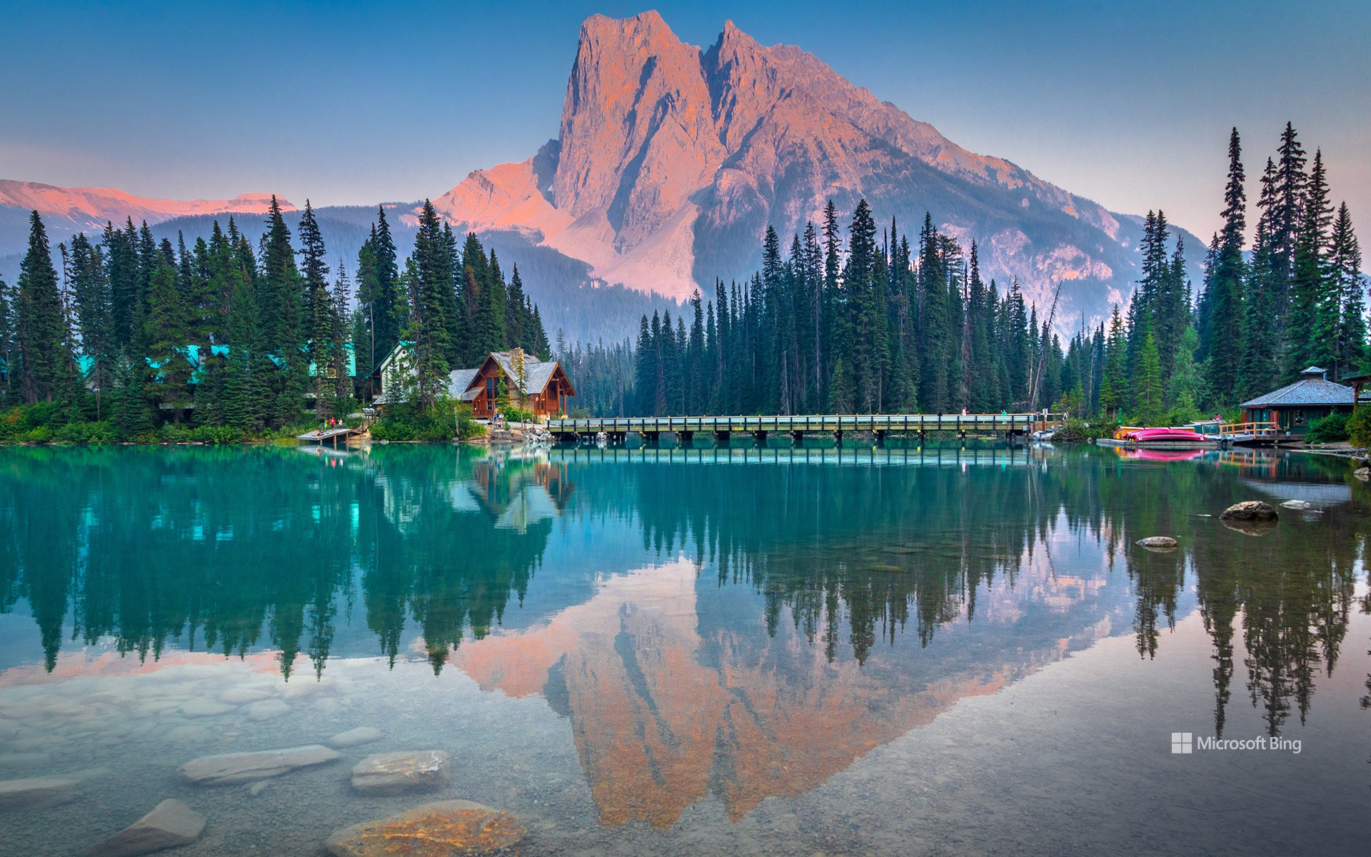
幽鹤国家公园的伯吉斯山和翡翠湖, 不列颠哥伦比亚省, 加拿大 Mount Burgess and Emerald Lake in Yoho National Park, British Columbia, Canada (© Feng Wei Photography/Getty Images)
化石、瀑布与林间小径 Fossil, falls and forest trailsFossils, falls and forest trails.
幽鹤国家公园,不列颠哥伦比亚省, 加拿大
“Yoho”听起来就像是人们站在山巅情不自禁发出的欢呼,而来到这里,你或许真的会这样做。幽鹤国家公园建于1886年,位于加拿大不列颠哥伦比亚省,以其峻峭的悬崖、冰川湖泊与雷鸣般的瀑布而闻名。作为加拿大第二古老的国家公园,它也是加拿大落基山国家公园世界遗产地的一部分。整个公园占地1,313 平方公里,其中的伯吉斯页岩化石遗址保存了逾5亿年前的海洋生物,对理解早期生物演化历程具有不可替代的科研价值。
漫步于此,你可能会邂逅麋鹿、山地山羊、土拨鼠,甚至偶尔出没的灰熊。森林冠层主要由黑松组成,而雪崩百合会在积雪融化后不久绽放。今日图片中翡翠湖展现了公园中的又一瑰宝。湖水之所以呈现鲜明的蓝绿色,是因为湖底存在大量由冰川磨蚀产生的细微岩粉,这类矿物颗粒能有效散射蓝绿光。湖泊四周环绕着森林山坡、雪崩通道,以及如伯吉斯山等耸立的高峰。如有机会来到这里,别忘了携带一些轻便食物,这片如画的湖畔美景可能会让你忍不住多绕几圈,流连忘返。
Tilting渔村, 福戈岛 , 纽芬兰和拉布拉多省, 加拿大 Fishing village of Tilting, Fogo Island, Newfoundland and Labrador, Canada (© FedevPhoto/Getty Images)
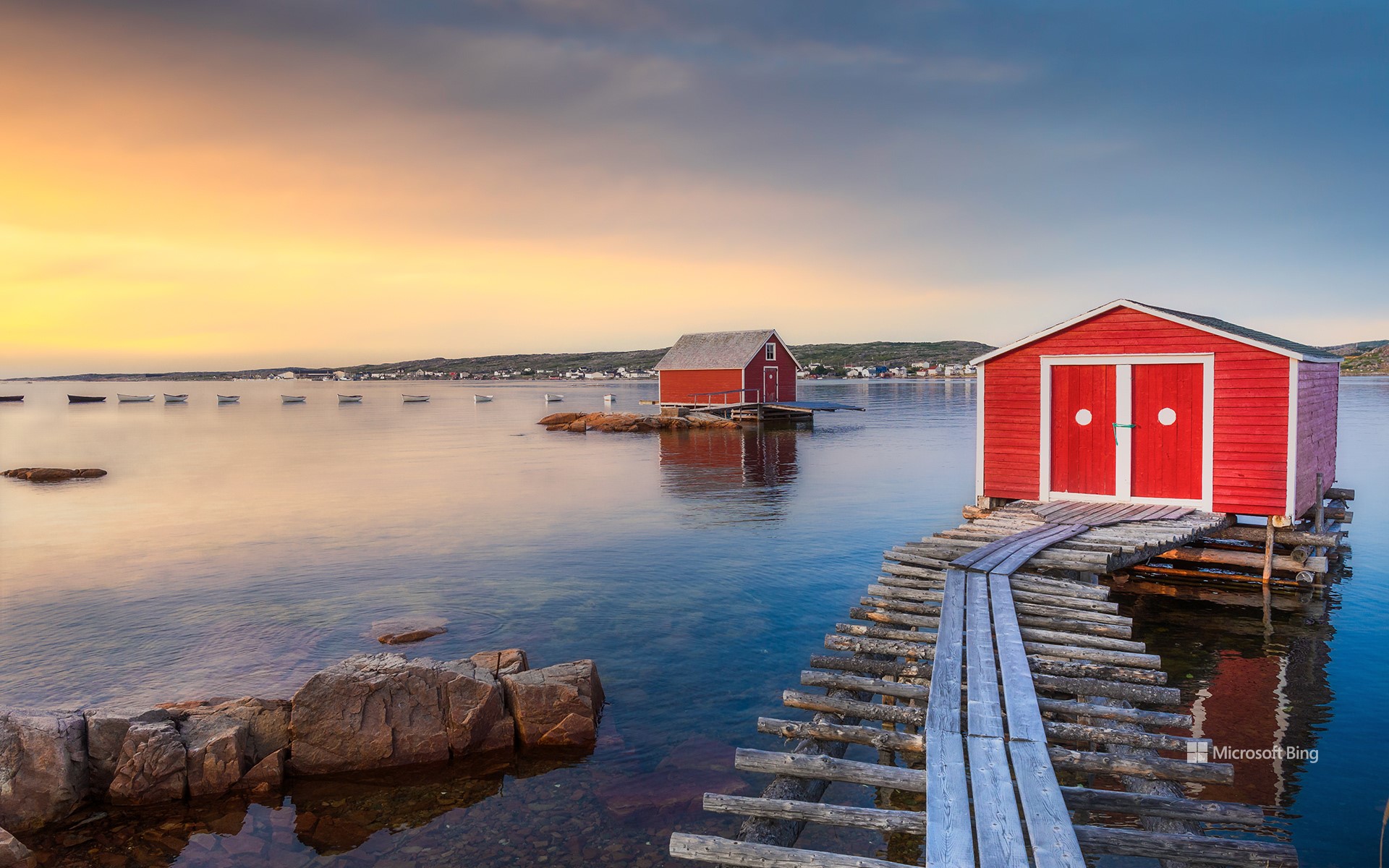
Tilting渔村, 福戈岛 , 纽芬兰和拉布拉多省, 加拿大 Fishing village of Tilting, Fogo Island, Newfoundland and Labrador, Canada (© FedevPhoto/Getty Images)
原始渔村的风貌 Authentic Fishing Village Charm
Tilting渔村, 加拿大
蒂林村最初由18世纪的爱尔兰移民所建立,是极少数至今仍保留爱尔兰渔村文化特色的社区之一。当地渔棚与住宅采用明亮色彩,不仅具有装饰功能,更是为了在浓雾或风雪中提高可见性。这种设计体现了早期居民兼具实用性与创造力的生活智慧。今天,加拿大迎来了建国158周年纪念日。从东海岸的历史小村到现代都市,从多元文化融合到壮丽自然风光,我们共同庆祝这个国家的历史积淀、文化底蕴与持续发展的未来愿景。
Happy Canada Day!
Today, Canada turns another year older. Canada Day is a nod to the moment when the country officially came together in 1867. What began as a confederation of Ontario, Quebec, New Brunswick, and Nova Scotia has grown into a nation of 10 provinces and 3 territories. Originally called Dominion Day, the name was changed to Canada Day in 1982—the same year the Constitution Act was signed, granting the country full control over its constitution. While Canada Day is not the country's 'Independence Day,' it's the closest thing to it. Canadians celebrate this holiday with fireworks, parades, concerts, and community events. Ottawa, the country's capital, hosts one of the biggest celebrations, featuring music and speeches on Parliament Hill.
On this day, it is hard to miss how the red and white houses in Tilting mirror the colors of the Canadian flag. Tilting, a village on Fogo Island in Newfoundland and Labrador, was settled by Irish immigrants in the 18th century. It remains a unique example of an Irish outport community that has preserved its cultural identity. The bright fishing sheds and homes weren't painted just for aesthetics; the hues make buildings easier to spot during heavy fog or snowfall. These vivid colors also reflect the practical, resourceful life of the people who settled here.