蒙特雷湾的大翅鲸(座头鲸),加利福尼亚州,美国 Humpback whales in Monterey Bay, California, USA (© Kiliii Fish/Cavan Images)

蒙特雷湾的大翅鲸(座头鲸),加利福尼亚州,美国 Humpback whales in Monterey Bay, California, USA (© Kiliii Fish/Cavan Images)
浪涛下的歌谣 Songs beneath the waves
世界鲸鱼日
世界鲸鱼日定于每年2月的第3个星期日,起源于20世纪80年代的夏威夷。当时,当地社区会庆祝座头鲸在迁徙季节重返近海。这一纪念日随后逐渐受到国际关注,尤其是在1986年国际捕鲸委员会通过商业捕鲸禁令之后,该举措成为全球鲸类保护的重要里程碑。
座头鲸修长的胸鳍格外醒目,而它们在繁殖季发出的复杂歌声,更为海洋增添了神秘回响。座头鲸的迁徙路线高度规律,常年沿岸而行,不仅成为季节更替的自然标志,也使其成为最早被关注和保护的鲸类之一。
鲸类保护不仅是禁捕,更关乎整个海洋环境。渔业、航运、噪音、塑料污染与海温变化,共同影响鲸的迁徙路径和觅食节奏。在蒙特雷湾,座头鲸的觅食依托于健康丰富的生态系统。猎物反哺海洋,营养滋养浮游生物,生命由此串联成完整的食物网。世界鲸鱼日,关注鲸鱼,也是关注海洋的未来。
World Whale Day
World Whale Day, observed on the third Sunday of February, began in the 1980s in Hawaii, where communities celebrated the seasonal return of migrating humpback whales. The day gained wider recognition after the International Whaling Commission's 1986 moratorium on commercial whaling, which marked a major milestone in international whale conservation.
Humpback whales are easily recognizable by their long pectoral fins and are known for their complex songs associated with breeding behavior. Their predictable migrations bring them close to shore, turning them into both a cultural marker of the season and a focal point for early conservation efforts.
Today, whale conservation extends far beyond hunting restrictions and includes how we use and manage the oceans more broadly. Fishing activity, major shipping routes, underwater noise, plastic waste, and rising ocean temperatures all influence whale movement and feeding patterns. Pictured here are humpback whales feeding cooperatively in Monterey Bay—a behavior that depends on healthy ecosystems and reliable prey availability. Whales also contribute to ocean systems by circulating nutrients that support plankton growth and marine food webs. World Whale Day highlights the ongoing importance of thoughtful ocean stewardship in maintaining balanced marine ecosystems.
死亡谷国家公园恶水盆地的盐滩, 加利福尼亚州, 美国 Salt flats in Badwater Basin, Death Valley National Park, California, USA (© Jim Patterson/TANDEM Stills + Motion)

死亡谷国家公园恶水盆地的盐滩, 加利福尼亚州, 美国 Salt flats in Badwater Basin, Death Valley National Park, California, USA (© Jim Patterson/TANDEM Stills + Motion)
对比之谷 The valley of contrasts
死亡谷国家公园周年纪念
死亡谷国家公园颠覆人们对沙漠的想象,横跨加利福尼亚州与内华达州,总面积约340万英亩,是美国面积最大的国家公园。盐沼、火山丘陵、流动沙丘与覆雪山峰交错分布,构成极端而多变的地貌。从海拔11000英尺的望远镜峰,到低于海平面282英尺的恶水盆地,这里呈现出鲜明且震撼的对比。
罕见暴雨唤醒山谷,野花短暂盛放,隐秘绿洲为野生动物提供栖息之所,近1000种植物在极端环境中顽强生长。恶水盆地是北美洲海拔最低点,广阔盐滩在天际线上裂解出几何纹理,呈现出近乎超现实的景观。早在1849年,廷比沙肖松尼人便在这片山谷中安居生活。
鉴于其独特且极端的地貌景观,1933年,时任美国总统赫伯特·胡佛正式将死亡谷指定为国家纪念地。1994年,《加州沙漠保护法案》进一步将其升格为国家公园,面积扩大一倍以上,使这片极端沙漠得以长期保存。
Death Valley National Park's Anniversary
Death Valley National Park challenges first impressions. Spanning more than 3.4 million acres across California and Nevada, it is the largest national park in the contiguous United States. Across this vast expanse, salt flats, volcanic hills, sweeping sand dunes, and distant snowcapped peaks create a landscape shaped by time and extremes. From the soaring heights of Telescope Peak, which rises over 11,000 feet above the desert floor, to the depths of Badwater Basin, 282 feet below sea level, the park is a study in contrasts.
Rare rainstorms can trigger brief bursts of wildflowers across parts of the valley, while hidden oases sustain wildlife and more than 1,000 plant species thrive against the odds. At Badwater Basin, pictured here, the land sinks to its lowest point in North America. Its blinding white salt flats stretch to the horizon, fractured into geometric patterns that make each step feel surreal. Long before it earned its foreboding name in 1849, the Timbisha Shoshone people called this valley home.
Recognizing its unique landscapes, President Herbert Hoover designated Death Valley a national monument on this day in 1933. That protection expanded in 1994, when the California Desert Protection Act elevated it to national park status and more than doubled its size, ensuring the preservation of this extraordinary desert for generations to come.
翡翠湾和范内特岛, 太浩湖, 加利福尼亚州, 美国 Emerald Bay and Fannette Island, Lake Tahoe, California, USA (© Bill Stevenson/Cavan Images)

翡翠湾和范内特岛, 太浩湖, 加利福尼亚州, 美国 Emerald Bay and Fannette Island, Lake Tahoe, California, USA (© Bill Stevenson/Cavan Images)
太浩湖视觉盛宴 Tahoe serving views
翡翠湾和范内特岛, 太浩湖, 加利福尼亚州
当一个地方同时被地质学家、电影镜头和民间传说反复提及,它必定不只是一处风景。横跨加州与内华达州的太浩湖,正是这样一片承载故事的水域。它诞生于冰河时代,断层活动与冰川雕琢造就了深不见底的湖盆,如今已成为美国最深的淡水湖之一。很久以前,瓦绍族人世代栖居湖畔,随季节更替捕鱼、采集。几个世纪后,矿工的脚步踏入此地,汽船划破湖面,太浩湖也由资源中心,转变为四季皆宜的休闲度假地。
今日画面中的翡翠湾,是太浩湖最上镜的角落之一。因水域较浅,湖水在这里呈现出更为明亮的碧色。水面之下,旧时的游艇与驳船静静躺卧,无声地讲述着湖泊的历史。位于湖心中央的范内特岛上,有一座小巧的石制“茶屋”,建于20世纪20年代,出自慈善家洛拉·奈特之手,她同时还主持兴建了附近的维京斯霍姆。故事并未止步于此,当地传说中提到的“太浩特西”,为这片湖水增添了一丝神秘感。也许某个不经意的水波,就会让你多看一眼,浮想联翩。
Emerald Bay and Fannette Island, Lake Tahoe, California
You know a place holds stories when geologists, filmmakers, and local folklore all claim it for different reasons. Lake Tahoe, straddling the border between California and Nevada, fits that bill perfectly. Formed during the Ice Age, the lake was shaped by faulting and glacial carving that created its deep basin. It is now one of the deepest freshwater lakes in the United States. For generations, the Washoe people lived around these clear waters, fishing and gathering seasonally. Centuries later, miners arrived, steamboats crossed the water, and Tahoe shifted from a resource hub to a year-round retreat.
Emerald Bay, seen in today's image, became one of its most photographed corners. Because the bay is shallower than the main lake, its water takes on a lighter hue. Beneath the surface rest old launches and barges, now preserved within Emerald Bay State Park. In the middle, Fannette Island rises with a small stone 'Tea House,’ a 1920s structure built by philanthropist Lora Knight, who also commissioned Vikingsholm nearby. And the story doesn't end here. Local stories mention 'Tahoe Tessie,' the lake's mythical creature. You never know—maybe you'll catch a ripple that makes you look twice.
缪尔树林国家保护区的巨型红杉树林, 加利福尼亚州, 美国 Giant redwood trees in Muir Woods National Monument, California, USA (© photo by canderson/Getty Images)

缪尔树林国家保护区的巨型红杉树林, 加利福尼亚州, 美国 Giant redwood trees in Muir Woods National Monument, California, USA (© photo by canderson/Getty Images)
时光在此处茁壮成长 Where time grows tall
缪尔树林国家保护区, 美国
走进巨人的国度吧。试着像拥抱一位温柔的巨人那样,把双臂环在红杉粗壮的树干上,触摸蕴藏着千年智慧的时间年轮。欢迎来到缪尔树林国家纪念地——它在1908年的今天正式诞生,坐落于旧金山北部,是一座由海岸红杉构成的壮丽殿堂。这里的红杉是地球上最高的树木,其中一棵高达约258英尺,相当于43个人从头到脚叠加的高度。这些树大多已经600到800岁,有的甚至跨越了千年。但对于一个最长能活到2000年的物种来说,它们依然算是“年轻的巨人”。在这片幽深的原始森林中,每一棵高耸入云的红杉都是时间的见证者,也是一位静默的守护者。
它们是如何屹立至今的?厚实且耐火的树皮与天然的单宁让红杉远离虫害与疾病;它们的根系虽只深入地下三四米,却能向四周延展近百英尺,与周围的同伴紧紧相扣,形成稳固的支撑。来自太平洋的雾气在干燥的夏季飘入森林,提供近四成的水分;倒下的巨木则化作“育苗木”,分解自身、滋养土地,为新生命铺下起点。当你步入这片森林,请向这些超越生命尺度的巨木轻轻致意。你的脚步声在时间的河流中荡起涟漪,顺着它缓缓向前,流向这些巨人耐心等待的未来。
Muir Woods National Monument anniversary
Step into the realm of giants. Try embracing a BFG (Big Friendly Giant) as you wrap your arms around a thousand years of wisdom in a single tree trunk. Welcome to Muir Woods National Monument—established on this day in 1908—a majestic hall of coastal redwoods just north of San Francisco. These towering redwoods are the tallest trees on Earth—one here stretches about 258 feet, roughly the height of 43 people stacked head to toe. Most are 600–800 years old, and some have stood for over a millennium, yet they're still considered 'young' for a species that can live for 2,000 years.
How do they endure? Thick, fire-resistant bark and tannins ward off insects and disease, while their roots—though only 10 to 13 feet deep—spread outward up to 100 feet and interlock with neighbors for stability. Fog drifting in from the Pacific provides nearly 40% of their water during dry summers, and fallen trees recycle nutrients as 'nurse logs,' fueling new life. As you enter this forest, bow to the trees that rise beyond life itself. Your footsteps ripple through the river of time, flowing toward the future these giants patiently await.
默塞德河, 优胜美地国家公园, 加利福尼亚, 美国 Merced River, Yosemite National Park, California, USA (© Ron and Patty Thomas/Getty Images)

默塞德河, 优胜美地国家公园, 加利福尼亚, 美国 Merced River, Yosemite National Park, California, USA (© Ron and Patty Thomas/Getty Images)
冰封的倒影 Frozen reflections
默塞德河, 优胜美地国家公园, 加利福尼亚
每一幅杰作都需要点睛之笔。而优胜美地的点睛之笔便是默塞德河。作为美国国家级“野生与风景河流”之一,这条水系起源于内华达山脉高处,汇集雪水,蜿蜒145英里,穿过优胜美地山谷,流入加州中央谷地。
这条河的西班牙语名"El Río de Nuestra Señora de la Merced",意为"慈悲圣母河",恰如其分地诠释了它的双重性:随季节更迭,时而宁静如镜,时而奔腾如潮。春季,融雪使河水暴涨,激流在石桥下奔涌,冲过如春瀑、内华达瀑等轰鸣的瀑布群,成为优胜美地的主角。夏季河水转为平缓,吸引着漂流者和游泳者。秋日落叶随水漂流,为河面添上点点金黄;冬日万物归寂,河面如镜般澄澈。有趣的是,这条河滋养着麦克卢尔湖——每逢秋冬季水位下降,湖底便会浮现一座鬼城。河流下游曾矗立着默塞德瀑布,这座淘金热时期繁华的磨坊小镇,如今已归于沉寂。
Merced River, Yosemite National Park, California
Every masterpiece needs a brushstroke to tie it together. For Yosemite National Park, that stroke is the Merced River—painting reflections of granite cliffs, pine forests, and waterfalls across its canvas. One of the National Wild and Scenic Rivers, this waterway begins high in the Sierra Nevada. It gathers meltwater and winds 145 miles west through Yosemite Valley into California's Central Valley.
Its Spanish name, 'El Río de Nuestra Señora de la Merced,' translates to 'River of Our Lady of Mercy,' and suits it well: it offers both calm and chaos depending on the season. Spring turns the river into Yosemite's main act, as snowmelt sends torrents rushing beneath stone bridges and past roaring waterfalls like Vernal and Nevada Falls. Summer brings a gentler flow that attracts rafters and swimmers. Fall adds a hint of gold as leaves drift downstream, and winter slows everything to a reflective stillness. Interestingly, it feeds Lake McClure, where a ghost town rises when water levels drop in fall and winter. Along its lower stretches once stood Merced Falls, a bustling mill town during the Gold Rush era, now lying quiet.
玛丽皇后号邮轮的夜景, 长滩, 加利福尼亚州, 美国 Night view of the RMS Queen Mary, Long Beach, California, USA (© Kit Leong/Shutterstock)

玛丽皇后号邮轮的夜景, 长滩, 加利福尼亚州, 美国 Night view of the RMS Queen Mary, Long Beach, California, USA (© Kit Leong/Shutterstock)
从“灰色幽灵”到幽灵传说 From 'Grey Ghost' to ghost stories
玛丽皇后号邮轮的夜景, 长滩, 加利福尼亚州
她注定不会被遗忘。1936年,“玛丽女王号” 首次横渡大西洋时,便夺尽风采。这艘装饰艺术风格的巨轮打破了航速纪录,承载过无数名流、皇室成员与政要。二战期间,她的身份从“海上宫殿”骤然转变为“灰色幽灵”,奢华尽数褪去,取而代之的是装载盟军部队的使命。1967年,航行30年后,她退役停泊在加州长滩。如今,她的甲板化身为酒店走廊、导览展区,成为一座活生生的海事历史纪念碑。
但她的传说并未随锚链一同沉寂。多年来,游客与船员都声称曾在空荡的走廊里听到回声,在金属甲板上听见脚步回荡,甚至在荒废的泳池边传来孩童的笑声。如今的“鬼魂之旅”常常以这些诡异故事为卖点,但历史学家指出,船上所有死亡事件均因自然原因,从未有过谋杀记录。今天的“玛丽女王号”既是历史的地标,也是传说的舞台。那么,她真的闹鬼吗?没有任何档案能够证实,但那些低语般的传闻,依旧让她的故事历久弥新。
Night view of the RMS Queen Mary, Long Beach, California
She was never meant to fade away. When the RMS Queen Mary sailed in 1936, she stole the spotlight across the Atlantic—an Art Deco liner that broke speed records and carried celebrities, royalty, and dignitaries. War transformed her from a floating palace into the 'Grey Ghost,' stripped of luxury and loaded with Allied troops. In 1967, after 30 years at sea, she retired to Long Beach, where her decks now serve as hotel corridors, guided exhibits, and a living monument to maritime history.
But her legend did not dock with her anchors. Over the years, guests and crew have spoken of echoes in empty corridors, footsteps reverberating on metal floors, and the laughter of a child near the deserted pool. Ghost tours highlight these eerie stories, though historians note that deaths aboard were due to natural causes, with no murders ever recorded. Today, the Queen Mary stands as both a heritage landmark and a stage for folklore. So, is she haunted? There are no records confirming it, yet the whispers keep her stories very much alive.
克拉克山脉, 内华达山脉, 约塞米蒂国家公园, 加利福尼亚州, 美国 Clark Range, Sierra Nevada, Yosemite National Park, California, USA (© Robb Hirsch/TANDEM Stills + Motion)

克拉克山脉, 内华达山脉, 约塞米蒂国家公园, 加利福尼亚州, 美国 Clark Range, Sierra Nevada, Yosemite National Park, California, USA (© Robb Hirsch/TANDEM Stills + Motion)
克拉克山脉的回声 Echoes from the Clark Range
克拉克山脉, 约塞米蒂国家公园, 加利福尼亚州
今年是约塞米蒂国家公园遗产的又一个里程碑。约塞米蒂国家公园自1864年以来一直受到保护,以其令人惊叹的壮丽景色和生态意义而闻名。约塞米蒂坐落在内华达山脉的中心地带,占地近1200平方英里,孕育着巨大的花岗岩、奔腾的瀑布和古老的红杉。克拉克山脉是其鲜为人知的瑰宝之一——今天照片中显示的崎岖高海拔山脊。它以约塞米蒂的第一位守护者、自然保护先驱盖伦·克拉克的名字命名。
克拉克山脉静静地守护着约塞米蒂南部的荒野,其山峰被冰川侵蚀,顶部覆盖着高山草甸。这里,微风轻拂白皮松,天空开阔,呼应着公园诞生时的远见卓识。
Clark Range, Yosemite National Park, California
This year marks another milestone in the legacy of Yosemite National Park, a sanctuary protected since 1864 and celebrated for its awe-inspiring grandeur and ecological significance. Nestled in the heart of the Sierra Nevada, Yosemite's nearly 1,200 square miles cradle granite giants, cascading waterfalls, and ancient sequoias. Among its lesser-known treasures lies the Clark Range—the rugged, high-elevation spine seen in today's image. It was named after Galen Clark, Yosemite's first guardian and a pioneer of conservation.
The Clark Range stands as a quiet sentinel to Yosemite's southern wilderness, its peaks etched by glaciers and crowned with alpine meadows. Here, the wind whispers through whitebark pines and the sky opens wide, echoing the spirit of foresight that birthed the park.
As we honor Yosemite's anniversary, we celebrate not only its grandeur but the enduring vision of those who fought to preserve it. From the valley's granite walls to the Clark Range's serene heights, this national park remains a living poem—written in stone, water, and time.
烟囱岩, 雷斯岬国家海岸, 加利福尼亚州, 美国 Chimney Rock, Point Reyes National Seashore, California, USA (© Enrique Aguirre Aves/Getty Images)

烟囱岩, 雷斯岬国家海岸, 加利福尼亚州, 美国 Chimney Rock, Point Reyes National Seashore, California, USA (© Enrique Aguirre Aves/Getty Images)
崎岖而狂野 Rugged and wild
雷斯岬国家海岸, 加利福尼亚州
这里没有经过精心打磨或精心策划——而这正是它的精髓所在。从旧金山向北驱车仅需一个多小时,便可抵达点雷斯岬国家海岸公园——一个雾气缓缓飘荡、 tule 鹿自由漫步、时间仿佛停滞的地方。该公园于1962年的今天由国会设立,旨在保护这片海岸线,供公众游览和环境保护之用。公园面积超过100平方英里,拥有令人惊叹的景观,从沿海草原和风吹雨打的岬角,到沙滩和道格拉斯冷杉林。
在公园的东界,烟囱岩(如今日图片所示)延伸至太平洋,高耸的悬崖与壮丽的海景相映成趣。其步道被视为西海岸观赏灰鲸迁徙的最佳地点之一。冬季时节,附近隐秘的海滩成为北象海豹的避难所,为观赏野生动物提供了绝佳机会。凭借超过490种鸟类、80多种哺乳动物及众多稀有植物,点雷耶斯(Point Reyes)跻身全国生态多样性最丰富的地区之列。超过150英里的步道邀请游客放慢脚步,沉浸于自然环境之中。
Point Reyes National Seashore in California
It's not polished or curated—and that's exactly the point. Drive just over an hour north of San Francisco, and you'll reach Point Reyes National Seashore—a place where fog drifts slowly, tule elk roam freely, and time seems to pause. Established by Congress on this day in 1962, the park was set aside to protect this piece of coastline for public enjoyment and environmental conservation. It covers over 100 square miles and features an impressive array of landscapes, from coastal prairie and blustery headlands to sandy shores and Douglas fir woodlands.
At the park's eastern boundary, Chimney Rock—seen in today's image—extends into the Pacific Ocean with towering cliffs and sweeping sea views. Its trail is considered one of the best spots on the West Coast to witness the gray whale migration. In the winter months, nearby secluded beaches become a refuge for northern elephant seals, offering an opportunity for wildlife viewing. With over 490 species of birds, more than 80 types of mammals, and numerous rare plants, Point Reyes ranks among the most ecologically diverse places in the country. Over 150 miles of trails invite visitors to slow their pace and immerse themselves in the surroundings.
太平洋公园,圣莫妮卡州立海滩,加利福尼亚州,美国 Pacific Park at Santa Monica State Beach, California, USA (© EXTREME-PHOTOGRAPHER/Getty Images)

太平洋公园,圣莫妮卡州立海滩,加利福尼亚州,美国 Pacific Park at Santa Monica State Beach, California, USA (© EXTREME-PHOTOGRAPHER/Getty Images)
完美的夜晚 A pier-fect evening
太平洋公园,圣莫尼卡州立海滩,加利福尼亚州
当夕阳西下,洒下橙色、粉色和紫色的光芒时,圣莫尼卡从悠闲的氛围中转为灯火通明。真的!这片海滩拥有超过3英里的沙滩、一座历史悠久的码头,以及风景如画的太平洋海岸公路,不仅仅是一条美丽的海岸线。让我们先从沙滩说起。宽阔、洁净,无论是打排球还是悠闲地读一本好书,这里都是日光浴爱好者和沙堡建造者的理想之地。
然后是圣莫尼卡码头。它建于1909年,至今仍屹立于木桩之上,拥有一个名为太平洋公园的游乐园、游乐场、餐厅,以及著名的太阳能摩天轮。想体验更多运动?马文·布劳德自行车道(Marvin Braude Bike Trail),又名斯特兰德(Strand),是一条22英里长的自行车道,蜿蜒穿过海滩。租一辆自行车,骑过滑旱冰者、遛狗者,以及一边吃冰淇淋一边自拍的游客。这里的冲浪也是一大亮点。初学者可以在这里体验人生中的第一波浪潮,而专业人士则时刻关注着更远处的海浪。
Pacific Park, Santa Monica State Beach, California
When the sun clocks out in streaks of orange, pink, and purple, Santa Monica goes from laid-back to lit up. Literally. With over 3 miles of sand, a historic pier, and the Pacific Coast Highway keeping things scenic, this beach is more than just a pretty shoreline. Let's start with the sand. Wide, clean, and ready for volleyball or just flopping down with a good book, it's ideal for sunbathers and sandcastle architects alike. And yes, 'Baywatch' was filmed along Santa Monica Bay. Feel free to run in slow motion.
Then there's the Santa Monica Pier. Built in 1909 and still standing tall on wooden legs, it's got an amusement park called Pacific Park, arcade, restaurants, and that famous solar-powered Ferris wheel. Up for more movement? The Marvin Braude Bike Trail, or the Strand, is a 22-mile bike path that zips right through the beach. Rent a cruiser and ride past rollerbladers, dog walkers, and tourists trying to juggle ice cream and selfies. Here, the surf is another draw. Beginners can catch their first wave here, while pros keep an eye on the swells farther out.
拉霍亚的潮汐池, 加利福尼亚州, 美国 Tide pools in La Jolla, California, USA (© Andrew Shoemaker/DanitaDelimont.com)
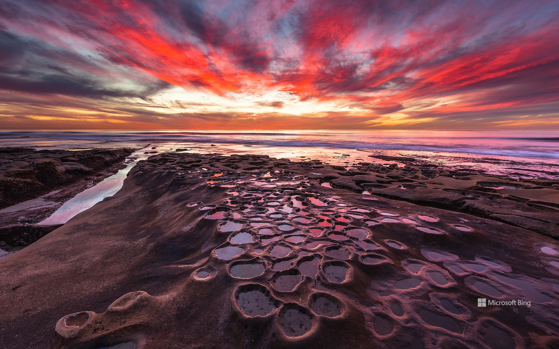
拉霍亚的潮汐池, 加利福尼亚州, 美国 Tide pools in La Jolla, California, USA (© Andrew Shoemaker/DanitaDelimont.com)
潮起潮落 Tide and seek
拉霍亚的潮汐池, 加利福尼亚州
并非每堂科学课都需要在教室里进行。在加利福尼亚州的拉霍亚,退潮后形成的潮池就在你脚下,向你揭示海洋的奥秘。在圣地亚哥这个沿海社区的岩石海岸线上,当潮水退去,海水被困在天然的凹坑中,就形成了潮池。这些浅水池自然分布在拉霍亚的砂岩和礁石之间,尤以风之海海滩、贝壳海滩、南卡萨海滩和医院角附近最为典型。海水停留在这些岩石凹槽中,为海兔、脆皮海星等多样的海洋生物提供了独特的栖息地。潮池的形成要归功于长期的侵蚀作用。海浪日复一日拍击砂岩和石灰岩的海岸,逐渐雕刻出能够蓄水的小坑洼。每天两次,随着潮水的涨落,这些潮池不断被海水淹没又重新显露,内部的生物也因此必须适应极为多变的环境。冬季白天潮水最低,是探索潮池的最佳时机。需要注意的是,这些潮池受到加州《海洋生物保护法》的保护。你可以欣赏这里的美景、观察潮池中的居民并拍照留念,但请不要触碰或打扰其中的任何生物。这是一堂免费的海洋生物课程,正在你眼前生动上演。
Tide pools in La Jolla, California
Not every science lesson requires a classroom. In La Jolla, California, tide pools teach you about ocean life—right at your feet. Along the rocky shoreline of this San Diego coastal neighborhood, tide pools form during low tide as seawater gets trapped in natural depressions. These shallow pools form naturally along La Jolla's rocky shorelines, especially near Windansea Beach, Shell Beach, South Casa Beach, and Hospital Point. The water that remains trapped in sandstone and reef depressions creates habitats for everything from sea hares to brittle stars. Over time, the tide pools are created through the process of erosion—waves hit the sandstone and limestone coastlines until they carve out pockets that hold water. Twice a day, as the tide moves in and out, these spaces flood and drain, challenging the survival skills of everything inside. Winter months, when tides are lowest during daylight hours, are ideal for observing them.