黑色熔岩海滩鸟瞰图,埃尔戈尔福,兰萨罗特岛,加那利群岛,西班牙 Aerial view of black lava beach, El Golfo, Lanzarote, Canary Islands, Spain (© Westend61/Adobe Stock)
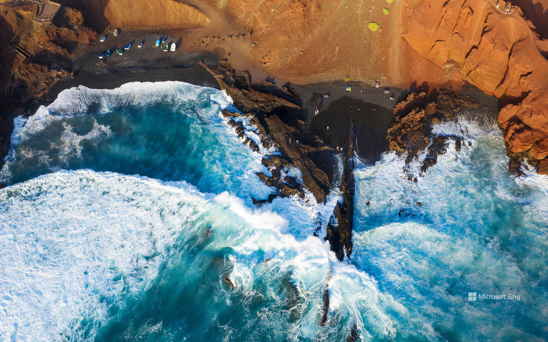
黑色熔岩海滩鸟瞰图,埃尔戈尔福,兰萨罗特岛,加那利群岛,西班牙 Aerial view of black lava beach, El Golfo, Lanzarote, Canary Islands, Spain (© Westend61/Adobe Stock)
黑色熔岩海滩, 加那利群岛,西班牙
在西班牙加那利群岛的兰萨罗特岛,大自然的地质创造力尽情挥洒。赭黄与铁锈色条纹交错的悬崖之下,深色沙滩与大西洋相接,这是延续数百万年的火山活动留下的杰作。这段地质故事中有一章发生在距今并不久远的年代:1730年至1736年间,兰萨罗特岛各处出现了众多火山喷口,熔岩覆盖数十平方英里的土地,掩埋了道路、村庄和农田。
图中的海滩坐落在埃尔戈尔福旁边,这是岛屿西岸的一个小渔村。村庄毗邻洛斯火山自然公园,而船只、海鲜餐厅和拍岸浪涛一如往常,仿佛眼前的景色再平常不过。附近著名的绿色潟湖查尔科德洛斯克利科斯位于一座部分坍塌的火山口内,并通过地下裂隙与大海相连。湖水那令人难以置信的翡翠色部分源于藻类,让碧绿湖水、黑色沙滩与蓝色大海同框,构成一幅色彩鲜明夺目的画面。无需滤镜。埃尔戈尔福自带专属调色盘。
Black lava beach, El Golfo, Lanzarote, Canary Islands, Spain
On Lanzarote, part of Spain's Canary Islands, geology got carried away. Dark sand meets the Atlantic beneath cliffs streaked with ocher and rust, the handiwork of volcanic activity spanning millions of years. One chapter of this story arrived remarkably recently: between 1730 and 1736, numerous vents opened across Lanzarote, sending lava over dozens of square miles and burying roads, villages, and farmland.
The beach in the image sits beside El Golfo, a tiny fishing village on the island's western shore. The settlement borders Los Volcanes Natural Park, while boats, seafood restaurants, and crashing waves carry on as if this scenery were perfectly ordinary. Nearby, the famous green lagoon Charco de los Clicos occupies a partially collapsed volcanic crater linked to the sea through underground fissures. Its improbable emerald color comes partly from algae, bringing green water, black sand, and blue sea into one strikingly vivid frame. No filter required. El Golfo comes with its own color palette.
马尔萨什洛克港口五彩斑斓的渔船,马耳他 Colorful boats in Marsaxlokk Harbor, Malta (© Klubovy/Getty Images)

马尔萨什洛克港口五彩斑斓的渔船,马耳他 Colorful boats in Marsaxlokk Harbor, Malta (© Klubovy/Getty Images)
色彩鲜艳的船只,历久弥新的传统 Bright boats, timeless traditions
马尔萨什洛克港口五彩斑斓的渔船,马耳他
色彩斑斓的“卢祖”(luzzu)——即马耳他的传统渔船——停满了马萨什洛克(Marsaxlokk)那避风港湾的水面;这座村庄坐落于马耳他东南沿海,距离首都瓦莱塔仅需短途车程。作为该国主要的渔业中心之一,这里的生活节奏始终与大海的律动保持着和谐的步调。村庄约有4000名居民,并以其充满活力的滨海区域而闻名——尤其是广受欢迎的周日鱼市,以及每天清晨满载新鲜渔获归来的船只。
“卢祖”(luzzu)这种传统船只适应了当地水域的特性,至今仍在使用。它们漆成鲜艳的蓝、黄、红、绿等色调,在港口内密集排列。每艘船的船头都绘有一对眼睛——这一源自古代地中海传统的图案,被认为能保佑水手在海上航行平安。这些船只共同构成了一道既实用又极具视觉冲击力的风景。
Colorful boats in Marsaxlokk Harbor, Malta
Colorful luzzus—traditional Maltese fishing boats—fill the sheltered harbor of Marsaxlokk, a village on Malta's southeastern coast. Just a short drive from Valletta, the island's capital, it remains one of the country's main fishing hubs, where daily life follows the steady pace of the sea. Home to roughly 4,000 residents, the village is also widely known for its lively waterfront, especially its popular Sunday fish market, and for the steady return of boats carrying fresh catches each morning.
The luzzus are adapted to local waters and remain in active use today. Painted in bright shades of blue, yellow, red, and green, they line the harbor in tight clusters. Each bears a pair of painted eyes on the bow—a symbol rooted in ancient Mediterranean traditions, believed to protect sailors at sea. Together, they create a scene that is as practical as visually striking.
鸟瞰弗吉尼亚爬山虎步道,达马斯克斯,弗吉尼亚州,美国 Aerial view of the Virginia Creeper Trail, Damascus, Virginia, USA (© Eifel Kreutz/Getty Images)

鸟瞰弗吉尼亚爬山虎步道,达马斯克斯,弗吉尼亚州,美国 Aerial view of the Virginia Creeper Trail, Damascus, Virginia, USA (© Eifel Kreutz/Getty Images)
穿越时光的足迹 Trailing through time
弗吉尼亚爬山虎步道, 达马斯克斯, 弗吉尼亚州
有些铁路会退出历史舞台,而“弗吉尼亚爬山虎步道”则实现了华丽转身。这条步道全长34.3英里,横贯弗吉尼亚州西南部,沿用了一条昔日的铁路线——该线路曾用于在阿巴拉契亚山脉间运输木材和铁矿石。步道那独特的名字,源自20世纪初那些在陡峭坡道上艰难爬行的蒸汽机车。
这条步道以被誉为“美国步道之城”的大马士革为中心,因其47座木制栈桥、壮丽的山景和丰富的户外探险活动而闻名。大马士革也是为数不多的阿巴拉契亚步道直接穿过镇中心主街的地点之一。
这条步道的一大亮点是从怀特托普站到大马士革长达17英里的下坡骑行路段;怀特托普站是全线最高点,海拔3,500英尺。骑行者几乎无需踩踏踏板,即可顺势滑行下降约1,600英尺。另一处引人注目的景观是“高架栈桥”,这是一座长550英尺、高出下方山谷100英尺的桥梁。受2024年“海伦”飓风破坏影响,该步道的上段目前因修复工作而关闭,而大马士革至阿宾登的路段则继续开放。
Virginia Creeper Trail, Damascus, Virginia
Some railways retire. The Virginia Creeper Trail simply changed gears. Stretching 34.3 miles through southwest Virginia, this trail follows a former rail line once used to haul lumber and iron ore through the Appalachian Mountains. Its unusual name traces back to the steam locomotives that labored up steep grades in the early 1900s.
Centered around Damascus, known as 'Trail Town USA,' the trail is famous for its 47 wooden trestles, sweeping mountain views, and outdoor adventures. Damascus is also one of the few places where the Appalachian Trail passes directly through a town's Main Street.
One of the trail's highlights is a 17-mile downhill ride from Whitetop Station, the route's highest point at 3,500 feet, to Damascus. Riders can coast nearly 1,600 feet downhill with little pedaling. Another standout feature is the High Trestle, a 550-foot bridge that rises 100 feet above the valley below. Following damage from Hurricane Helene in 2024, the upper section remains closed for restoration, while the Damascus-to-Abingdon section continues to stay open.
陆地与海洋的鸟瞰图,维多利亚州,澳大利亚 Aerial view of land and ocean, Victoria, Australia (© Nearmap/Getty Images)

陆地与海洋的鸟瞰图,维多利亚州,澳大利亚 Aerial view of land and ocean, Victoria, Australia (© Nearmap/Getty Images)
陆地与海洋的鸟瞰图 The land of moving shorelines
陆地与海洋的鸟瞰图,维多利亚州,澳大利亚
维多利亚州位于澳大利亚东南部,坐拥由南大洋雕琢而成的绵延千余英里的海岸线。从高空俯瞰,这里的海滩宛如一条条宽阔的浅色沙带,边缘环绕着碧绿的海水与崎岖的峭壁。这种海陆交融的独特景致构成了该地区的主要魅力所在。著名的“大洋路”沿这段海岸线蜿蜒延伸约150英里,途经热门冲浪胜地、林木葱郁的海角以及各具特色的海滨小镇。
这里最引人注目的景观之一是“十二使徒岩”——这些高耸的石灰岩柱历经数百万年的风浪侵蚀而形成。附近海域既有像贝尔斯海滩那样海浪汹涌的冲浪胜地,也有宁静的海湾,那里沿海植被与开阔的沙滩交相辉映。远离海岸,农田与国家公园构成了别样的景致,不仅孕育着丰富的野生动植物,还设有风景优美的步道。维多利亚州首府墨尔本坐落于菲利普港湾畔,作为该州的核心城市,它彰显了这片土地兼具文化活力与自然多样性的特质——从高耸的阿尔卑斯山峰到原始粗犷的海岸线,风光无限。
Aerial view of land and ocean, Victoria, Australia
Victoria, a southeastern state of Australia, extends along more than 1,000 miles of coastline shaped by the Southern Ocean. From above, its beaches appear as sweeping bands of pale sand edged by turquoise waters and rugged cliffs. This dynamic interaction of land and sea defines much of the region's appeal. The famous Great Ocean Road traces roughly 150 miles of this shoreline, winding past popular surf spots, forested headlands, and seaside towns.
One of its most striking sights is the Twelve Apostles, towering limestone stacks formed over millions of years by wind and waves. Nearby stretches feature powerful surf breaks like Bells Beach and quieter coves where coastal vegetation meets open sand. Beyond the shore, farmland and national parks provide contrast, supporting wildlife and scenic trails. Victoria's capital, Melbourne, sits on Port Phillip Bay, anchoring a state known for both cultural energy and natural variety, from alpine peaks to untamed coastlines.
威尼斯鸟瞰图, 意大利 Aerial view of Venice, Italy (© Clement Leonard/Getty Images)

威尼斯鸟瞰图, 意大利 Aerial view of Venice, Italy (© Clement Leonard/Getty Images)
威尼斯的灵魂 The soul of Venice
威尼斯鸟瞰图,意大利
从高空俯瞰威尼斯,宛如一幅迷人的水上画卷,但这座意大利瑰宝真正的魅力,藏在古老墙垣与曲折水巷之间。公元5世纪,它在潟湖中的一簇岛屿上诞生,由沼泽蜕变为海上霸主。中世纪时期,威尼斯成为连接欧洲与东方的重要贸易枢纽,财富与文化在此交织。如今,哥特式宫殿、文艺复兴艺术,以及圣马可大教堂、公爵宫、里亚托桥等地标,仍在诉说这座城市的辉煌历史。
威尼斯的魅力,不仅在于桥梁与运河,更在于那些才华横溢的灵魂。《马可·波罗游记》讲述了这位探险家的奇幻旅程,维瓦尔第在这里谱写出《四季》的乐章。威尼斯更是文学与艺术的灵感源泉:托马斯·曼的《威尼斯之死》、莎士比亚的《威尼斯商人》和《奥赛罗》,以及亨利·詹姆斯的《阿斯彭文稿》,都在这座城市的光影中诞生。
如今的威尼斯,在历史魅力与现代挑战之间保持微妙的平衡:既要守护脆弱的古迹,又要应对汹涌的游客潮。贡多拉依旧在百年老墙的倒影中轻轻滑过,而狂欢节等传统节庆,则让这座城市的古老风情延续至今。
Aerial view of Venice, Italy
Seeing Venice from above is mesmerizing, but this Italian gem's true magic lies within its walls and waterways. Founded in the 5th century on a cluster of islands in the Venetian Lagoon, the early settlement rose from marshland to become a maritime powerhouse. By the Middle Ages, it had evolved into a major hub for trade between Europe and the East, fueling immense wealth and cultural growth. The city's grandeur shines through its Gothic palaces, Renaissance art, and landmarks such as St. Mark's Basilica, the Doge's Palace, and the Rialto Bridge.
Venice is celebrated not only for its iconic architecture and interwoven canals but also for the brilliant minds who shaped its legacy. 'The Travels of Marco Polo' chronicles the adventures of the Venetian merchant and explorer, and Antonio Vivaldi—composer of 'The Four Seasons'—was also born here. The city has inspired timeless works, including Thomas Mann's 'Death in Venice,' Shakespeare's 'The Merchant of Venice' and 'Othello,' and Henry James's novella 'The Aspern Papers.'
Today, Venice balances historic charm with modern challenges—from preserving fragile architecture to managing tourism. Gondolas glide past centuries-old facades, while festivals like Carnevale keep traditions alive.
斗兽场鸟瞰图,罗马,意大利 Aerial view of the Colosseum, Rome, Italy (© Nico De Pasquale Photography/Getty Images)

斗兽场鸟瞰图,罗马,意大利 Aerial view of the Colosseum, Rome, Italy (© Nico De Pasquale Photography/Getty Images)
条条大路通罗马 All roads lead to Rome
斗兽场,罗马,意大利
觉得现代体育赛事已经足够精彩了吗?在古罗马时代,观众们坐在斗兽场中目睹的表演要激烈得多。这座宏伟的圆形露天竞技场由罗马皇帝韦斯帕先于公元72年下令建造,其子提图斯于公元80年完工。与早期依山而建、借助地形支撑的剧场不同,罗马斗兽场完全独立矗立,是一座自成体系的建筑奇迹。斗兽场由石块与混凝土建成,拱门与穹顶结构支撑着可容纳多达5万名观众的竞技场。角斗士的搏斗、异国野兽的展示,甚至模拟海战,都令观众热血沸腾地下的升降机与暗门让场景转换瞬息万变,充满戏剧张力。
进入中世纪后,斗兽场被赋予了新的用途:曾一度被改作教堂,后来又成为堡垒。几个世纪以来,它经受了雷击、地震与污染的破坏。建筑中大量的石灰华与大理石被重新利用,修建宫殿、防御工事,甚至教堂。这种做法被称为“拆卸再利用”, 它让斗兽场的碎片真正融入了罗马这座不断演变的城市。直到19世纪,人们才开始对其进行系统的保护。如今,罗马斗兽场作为受保护的世界文化遗产,每年吸引近 700 万名游客,依然是意大利最具象征意义的地标之一,见证着古罗马的荣耀与永恒。
Colosseum, Rome, Italy
Think modern sports are dramatic? Ancient Romans had front-row seats to spectacles far more intense inside the Colosseum. Commissioned by the Flavian emperor Vespasian in 72 CE and finished by his son Titus in 80 CE, this amphitheater broke tradition with its predecessors that were built into hillsides for natural support. Instead, the Colosseum was a fully free-standing architectural giant. Crafted from stone and concrete, its arches and vaults supported an arena that could host up to 50,000 spectators. Gladiators, exotic animals, and even staged sea battles thrilled the crowds, while hidden elevators and trapdoors created sudden, dramatic appearances.
During the Middle Ages, the Colosseum found new purposes: first as a church, later as a fortress. Over the centuries, it endured damage from lightning strikes, earthquakes, and pollution. Much of its marble and travertine was also reused in palaces, fortifications, and even churches—a practice known as 'spolia,' which quite literally wove pieces of the structure into the evolving city of Rome. It wasn't until the 19th century that serious preservation began. Today, recognized as a protected monument and welcoming nearly 7 million visitors annually, the Colosseum remains one of Italy's most iconic landmarks.
马蒂莫阿帕沼泽保护区泥炭地鸟瞰图, 芬兰 Aerial view of peatland in Martimoaapa Mire Reserve, Finland (© romikatarina/Shutterstock)

马蒂莫阿帕沼泽保护区泥炭地鸟瞰图, 芬兰 Aerial view of peatland in Martimoaapa Mire Reserve, Finland (© romikatarina/Shutterstock)
芬兰的活泥炭地 Finland's living peatland
马蒂莫阿帕沼泽保护区,芬兰
芬兰的沼泽大多是由泥炭地组成,它们源自大约 12,000 年前上一个冰河时期结束后,沉积物与苔藓不断堆积、分解而成。
这仅仅是个开始。考古学家在这里发现了曾用来储存肉类的半咸水坑,以及一个约33英尺宽的神秘石圈——仿佛源自北方神话。它的用途?至今仍是谜。更近代的历史则留存在萨乌纳萨里桑拿屋中,它曾是伐木工小屋的一部分,为在这片北方森林中劳作的男人们提供温暖、休息,以及烘干身体的地方。
在这里野生动物随处可见,为这片土地增添了生机。近百种鸟类在此筑巢,从天鹅、鹤到猫头鹰和红隼。保护区内设有多条长短不一的步道,长度从 1.9 英里到 8 英里不等,沿途散布着小屋与篝火点,邀请人们夏日徒步探索,或在冬季滑雪穿行。
Martimoaapa Mire Reserve, Finland
Today, we step into the Martimoaapa Mire Reserve in Finland, where wide, cold-climate wetlands and peatlands stretch across a landscape shaped over thousands of years. This reserve is more than just mires—it carries layers of history. During Finland's Prohibition era (1919–1932), smugglers hauled sacks of liquor from Sweden across these bogs, following a 'spirits' route that passed through Martimoaapa. Parts of that path can still be traced today. Imagine trekking with a heavy pack over soggy ground—would you have made it?
This is just the beginning. Here, archaeologists have discovered brackish pits once used to store meat, and a mysterious stone circle about 33 feet wide—like something out of a northern myth. Its purpose? Still unknown. More recent history lives on in the Saunasaari sauna, once part of a logging cabin built for men who worked these boreal forests. It gave them warmth, rest, and a place to dry off.
Wildlife, ever-present, completes the picture. Nearly 100 bird species nest here, from swans and cranes to owls and kestrels. Trails ranging from 1.9 to 8 miles, dotted with huts and campfire sites, invite you to explore—on foot or on skis in winter.
从地球上空225英里处俯瞰墨西哥湾沿岸各州的夜间景象 Nighttime view of the Gulf Coast states from 225 miles above Earth (© Stocktrek Images/Getty Images)

从地球上空225英里处俯瞰墨西哥湾沿岸各州的夜间景象 Nighttime view of the Gulf Coast states from 225 miles above Earth (© Stocktrek Images/Getty Images)
巨大的成功 A stratospheric success
墨西哥湾沿岸的夜景
看不见的气体、老式发胶和卫星有什么共同点?它们都在历史上最伟大的环境复苏之一中发挥了作用。从225英里高空俯瞰,墨西哥湾沿岸如同一片星辰——点点灯光散落在黑暗中。但真正让这一景象成为可能的,却是肉眼无法看见的:臭氧层,它默默地保护着下方的一切免受太阳紫外线的侵害。到了20世纪80年代,这层屏障正迅速变薄——被曾用于制冷和气溶胶产品的化学物质所破坏。解决方案?一项全球协议。1987年签署的《蒙特利尔议定书》促使臭氧层破坏物质迅速被淘汰。如今,卫星数据显示南极上空的臭氧层空洞正在缩小。科学家认为,到本世纪中叶,它可能完全愈合。
9月16日,我们迎来国际保护臭氧层日——这是一个庆祝科学、全球合作与共同意志的节日。它提醒我们,再小的分子也可能产生巨大的影响。但它也证明,只要采取正确的行动,即使是肉眼看不见的损害也能被修复。
Nighttime view over the Gulf Coast
What do invisible gases, vintage hairspray, and satellites have in common? They all played a role in one of the greatest environmental comebacks in history. Seen from 225 miles above, the Gulf Coast glows like a constellation—clusters of light scattered across the dark. But what truly makes this view possible can't be seen: the ozone layer, silently shielding everything below from the sun's ultraviolet rays. By the 1980s, that shield was thinning fast—damaged by chemicals once used in refrigeration and aerosol products. The solution? A global pact. The Montreal Protocol, signed in 1987, led to a swift phase-out of ozone-depleting substances. Today, satellites show that the hole over Antarctica is shrinking. Scientists believe it could be fully healed by mid-century.
On September 16, we mark the International Day for the Preservation of the Ozone Layer—a celebration of science, global cooperation, and collective will. It's a reminder that no molecule is too small to have a massive impact. But it's proof, too, that with the right action, even invisible damage can be undone.
马约尔广场鸟瞰图, 马德里, 西班牙 Aerial view of Plaza Mayor, Madrid, Spain (© AirPano LLC/Amazing Aerial Agency)

马约尔广场鸟瞰图, 马德里, 西班牙 Aerial view of Plaza Mayor, Madrid, Spain (© AirPano LLC/Amazing Aerial Agency)
网格的心脏 The heart of the grid
马约尔广场鸟瞰图, 马德里,西班牙
从高处俯瞰,马德里(西班牙首都)的马约尔广场(Plaza Mayor)上,整齐的拱廊与瓦片屋顶交织成一幅令人着迷的建筑和谐画卷。这片历史悠久的空间曾是热闹的集市广场“阿拉巴尔广场”(Plaza del Arrabal)的所在地,见证了这座城市数百年来的变迁。这一转变始于1561年,当时皇家法院从托莱多迁至马德里,广场随之归入马德里管辖。受秩序与宏伟愿景的启发,菲利普二世重新构想了这片广场——尽管实际施工直至菲利普三世统治时期的1617年才正式展开。
该广场采用矩形布局,四周环绕着三层高的建筑,共设有237个朝内的阳台。广场共有十个入口,其中九个设有门禁。广场中央矗立着菲利普三世的骑马雕像,该雕像于1848年增设。多年来,该广场曾举办过从地方节庆、斗牛活动到封圣仪式和皇家典礼等各类活动。如今,它仍是一个充满活力的聚集地,举办复活节鼓乐游行、户外音乐会、年度圣诞市场,以及每周日早上的邮票和硬币收藏家市场。
Aerial view of Plaza Mayor, Madrid, Spain
Seen from above, the uniform arcades and tiled rooftops of Plaza Mayor in Madrid—the capital of Spain—create a captivating architectural harmony. Once the site of a bustling market square known as the Plaza del Arrabal, this historic space has witnessed the city's transformation over the centuries. The shift began in 1561, when the plaza came under Madrid's jurisdiction after the royal court moved from Toledo. Inspired by a vision of order and grandeur, King Philip II reimagined the square—though construction did not actually begin until 1617, under the reign of Philip III.
Featuring a rectangular layout, the plaza is framed by three-story buildings with 237 inward-facing balconies. It has 10 entrances, nine of which are gated. At its center stands the equestrian statue of Philip III, added in 1848. Over the years, the square has hosted everything from local festivities and bullfights to beatifications and royal ceremonies. Today, it remains a vibrant gathering place, featuring Easter drum parades, outdoor concerts, an annual Christmas market, and a Sunday morning market for stamp and coin collectors.
大加那利岛拉斯帕尔马斯色彩缤纷的房屋鸟瞰图,西班牙 Aerial view of colorful houses, Las Palmas de Gran Canaria, Spain (© Marco Bottigelli/Getty Images)
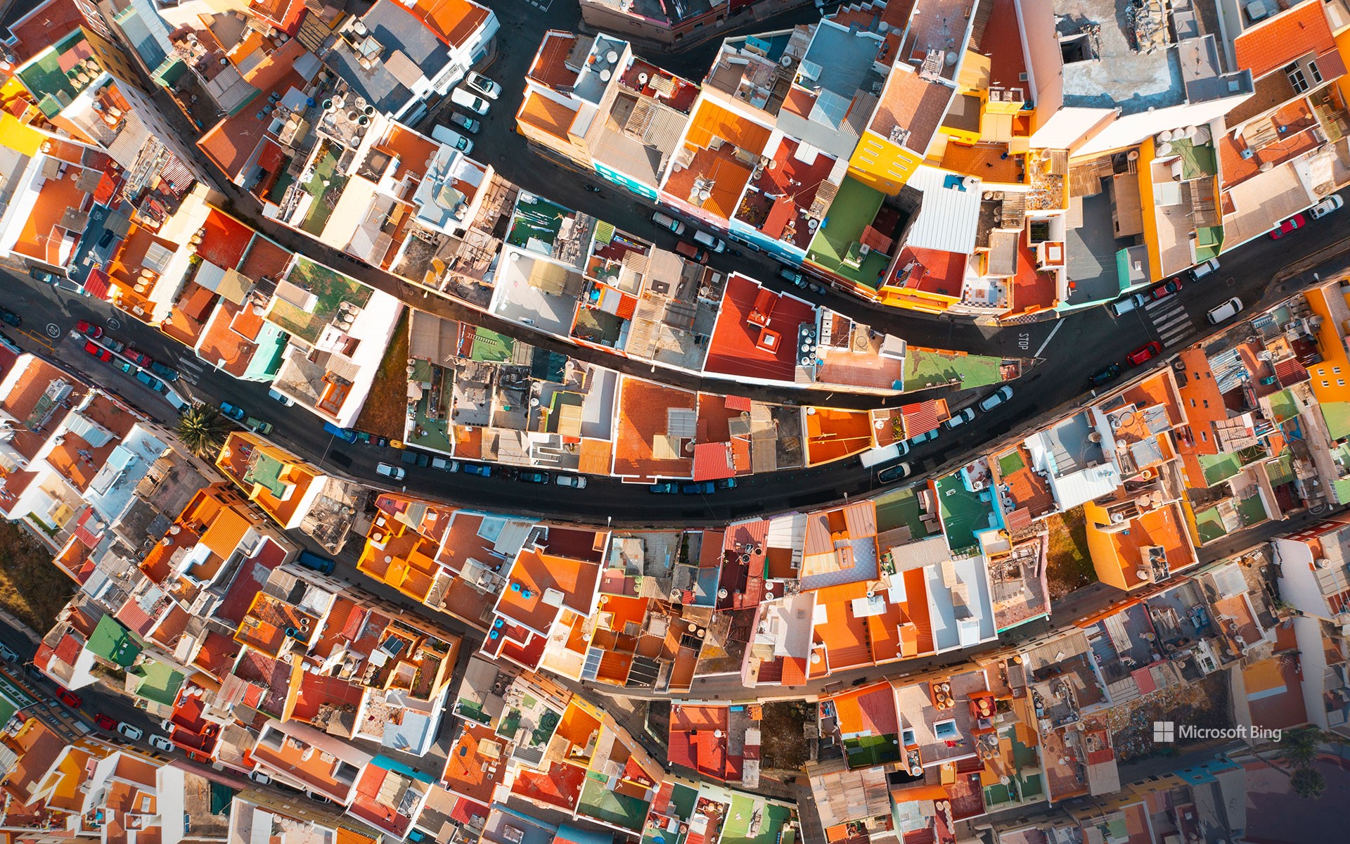
大加那利岛拉斯帕尔马斯色彩缤纷的房屋鸟瞰图,西班牙 Aerial view of colorful houses, Las Palmas de Gran Canaria, Spain (© Marco Bottigelli/Getty Images)
生活的画卷 Canvas of life
大加那利岛拉斯帕尔马斯色彩缤纷的房屋,西班牙
如果你渴望在这个夏天探索一片遥远的风景,不妨跟随我们的步伐,走进拉斯帕尔马斯。这座充满活力的城市是加那利群岛的两大首府之一,同时也是群岛中人口最多的城市。加那利群岛隶属于西班牙,位于大西洋之上,而拉斯帕尔马斯坐落于大加那利岛东北海岸,拥有超过38万居民,是该地区重要的港口及商业中心。从空中俯瞰,这座城市色彩斑斓的建筑为像圣胡安山这样的社区增添了鲜明的层次感,这里的房屋依山而建。拉斯帕尔马斯建于1478年,历史底蕴深厚,曾受到西班牙殖民、海上贸易与移民潮的多重影响。如今,它以典型的亚热带沙漠气候闻名,冬季平均气温约16摄氏度,夏季则在27摄氏度左右。同时,这里还拥有被誉为欧洲最佳城市海滩之一的拉斯坎特拉斯海滩。
Colorful houses of Las Palmas de Gran Canaria, Spain
If you're eager to explore faraway landscapes this summer, let us take you to Las Palmas de Gran Canaria. This vibrant city is one of the capitals and the most populous city in the Canary Islands, an archipelago belonging to Spain. Located on the northeastern coast of the island of Gran Canaria, Las Palmas is home to over 380,000 people and serves as a major port and commercial hub in the Atlantic. The city's distinctive palette of painted buildings—seen here from above—adds striking color to neighborhoods like Risco de San Juan, where homes are built into the hillsides. Founded in 1478, Las Palmas has a layered history shaped by Spanish colonization, maritime trade, and migration. Today, it is known for its subtropical desert climate—with average temperatures ranging from 60°F in winter to 80°F in summer—and for Las Canteras Beach, one of the best urban beaches in Europe.
Thanks to its proximity to the African continent, this Spanish island offers insight into two cultures: Spanish customs and African traditions combine to form a unique blend in the heart of the volcanic archipelago.