太平洋沿岸国家公园保护区,温哥华岛,加拿大 Pacific Rim National Park Reserve, Vancouver Island, Canada (© EmilyNorton/Getty Images)

太平洋沿岸国家公园保护区,温哥华岛,加拿大 Pacific Rim National Park Reserve, Vancouver Island, Canada (© EmilyNorton/Getty Images)
掠海而过 Passing through, making waves
掀起浪花
在加拿大,“太平洋沿岸鲸鱼节”庆祝成千上万头灰鲸每年春季的迁徙盛况——它们沿着岛屿西海岸近岸而行,场面壮观。这项节日由当地社区于20世纪80年代发起,旨在纪念灰鲸从墨西哥下加利福尼亚的繁殖潟湖启程,踏上北返旅程的重要时刻。
随着时间推移,这一节庆已发展为为期数天的系列活动,聚焦海洋教育与负责任的野生动物观赏。每年3月及4月初是观鲸高峰期,灰鲸在北迁途中会沿海岸停歇、觅食。想知道它们要游多远吗?一次完整的往返迁徙通常长达约1万至1.4万英里。
太平洋沿岸国家公园保护区在这段故事中扮演着重要角色。它受海浪冲刷的海岸线和近海水域,正好位于灰鲸迁徙路线之上。灰鲸是这个季节的主角,而随着座头鲸数量恢复,它们的身影也越来越常见。从长滩的观鲸点到宁静的海角,只要耐心——再加上一点运气——游客就有机会收获难忘的观鲸瞬间。
Pacific Rim Whale Festival
Spring break on Vancouver Island looks a little different. In Canada, the Pacific Rim Whale Festival celebrates the annual spring migration of thousands of gray whales as they pass close to the island's west coast. Created by local communities in the 1980s, the festival marks the whales' return north from breeding lagoons in Baja California, Mexico.
Over time, the festival has grown into a multi-day event centered on ocean education and respectful wildlife viewing. March and early April are peak months, as gray whales move north and pause to rest and feed along the coast. Curious how far they go? A full round-trip migration typically spans about 10,000 to 14,000 miles.
Pacific Rim National Park Reserve plays a key role in this story. Its wave-battered shoreline and nearshore waters sit directly along the migration route. Gray whales dominate the season, while humpback whales are increasingly spotted as their populations recover. From Long Beach lookouts to quiet headlands, patience—and a little luck—can reward visitors with unforgettable moments.
兰扬石门,位于英格兰康沃尔郡的一座兰扬新石器时代石棚墓,英国 Lanyon Quoit, a Neolithic dolmen in Cornwall, England (© Helen Hotson/Alamy)

兰扬石门,位于英格兰康沃尔郡的一座兰扬新石器时代石棚墓,英国 Lanyon Quoit, a Neolithic dolmen in Cornwall, England (© Helen Hotson/Alamy)
圆周率的古老启示 An ancient angle on Pi
庆祝圆周率日
在圆周率尚未有名字之前,人们就被它的奥秘所吸引。每年的3月14日,被定为“圆周率日”,以纪念数学中最著名的常数之一。这个日期正好对应圆周率π的前三位数字(3.14),即圆的周长与直径之比。圆周率无穷且不循环的小数部分长期以来一直令学者们着迷。现代的庆祝活动始于1988年,当时物理学家拉里·肖(Larry Shaw)用一种特别的方式纪念这一天:享用美味的派(pie)。
今天的画面带我们来到英国西南部的康沃尔,那里矗立着兰扬石门——其形状仿佛圆周率的符号 π,从开阔的荒原上拔地而起。这座新石器时代的石墓建于公元前3500年至前2500年之间,曾是更大型建筑的一部分。抬起巨大的顶石需要精确的平衡与比例知识,这些早期的理念让建筑者在文字数学出现之前,就能够掌握形状与尺度的运用。
在圆周率日,这样的遗迹提醒我们:数学思维源于实践中的挑战。在符号出现在黑板之前,人类对测量的理解已经在石头中塑造着世界。
Celebrating Pi Day
Long before pi had a name, people were drawn to its mystery. Every year on March 14, Pi Day highlights one of math's most recognizable constants. The date reflects the first three digits of pi (π), the ratio of a circle's circumference to its diameter: 3.14. Pi's infinite, nonrepeating decimal has fascinated thinkers for a long time. The modern celebration began in 1988, when physicist Larry Shaw marked the day with a fitting tribute: serving pie.
Today's image takes us to Cornwall in southwestern England, where Lanyon Quoit—in the shape of π—rises from open moorland. Built between 3,500 and 2,500 BCE, this Neolithic dolmen once stood as part of a larger structure. Raising its massive capstone required knowledge of balance and proportion. These early concepts helped builders work with shape and scale long before written mathematics existed.
On Pi Day, sites like this remind us that mathematical thinking evolved from practical challenges. Even before symbols appeared on chalkboards, ideas about measurement were already shaping the world in stone.
邦港圣母教堂拱顶,莱萨布勒多洛讷,法国 Vaults of the Church of Notre Dame de Bon-Port, Les Sables-d'Olonne, France (© Helmut Meyer zur Capellen/Alamy)

邦港圣母教堂拱顶,莱萨布勒多洛讷,法国 Vaults of the Church of Notre Dame de Bon-Port, Les Sables-d'Olonne, France (© Helmut Meyer zur Capellen/Alamy)
静谧的石之杰作 A quiet masterpiece in stone
邦港圣母堂,法国莱萨布勒多洛讷
在法国西部海滨小镇莱萨布勒多洛讷的邦港圣母堂拱顶下,石质拱肋依旧引导着视线向上。高耸的拱顶自1646年开始建造,这座教堂自1993年被列为法国历史古迹,坐落在一座13世纪小礼拜堂的旧址上,静静讲述着大西洋沿岸悠久的精神文化与历史故事。
随着莱萨布勒多洛讷逐渐发展为渔港,邦港圣母堂也成为远洋水手出航前的重要停靠点。教堂融合哥特式拱形与文艺复兴细节的设计,反映了建筑、信仰与海洋生活紧密交织的时代。持续的修复工作,使拱顶在潮湿、盐雾弥漫的海岸环境中得以保存。游客常会注意到石材之间的光影流转和声响的柔和,让这片宁静的空间继续讲述着精湛工艺、信仰与几世纪航海历史的故事。
Church of Notre Dame de Bon-Port, Les Sables-d'Olonne, France
Under the vaulted ceiling of Notre-Dame de Bon-Port in Les Sables-d'Olonne, a seaside town in western France, the stone ribs still guide the gaze upward. Construction of the soaring vaults began in 1646. The church—officially recognized as a French historic monument since 1993—stands on the site of a 13th-century chapel, a reminder of deep-rooted spiritual life on the Atlantic coast.
As Les Sables-d'Olonne grew into a fishing port, the church became a waypoint for sailors preparing for ocean crossings. Its blend of Gothic arches and Renaissance details reflects a time when architecture, faith, and maritime life were closely intertwined. Ongoing restoration efforts help preserve the vaults amid the damp, salt-laden coastal air. Visitors often notice how sound softens and light shifts across the stone, creating a quiet interior that continues to connect craftsmanship, belief, and centuries of seafaring history.
盛开的桃树, 谢萨, 穆尔西亚, 西班牙 Peach trees in bloom, Cieza, Murcia, Spain (© Juan Maria Coy Vergara/Getty Images)

盛开的桃树, 谢萨, 穆尔西亚, 西班牙 Peach trees in bloom, Cieza, Murcia, Spain (© Juan Maria Coy Vergara/Getty Images)
一个美好的春天 A peachy keen spring
谢萨的桃树,穆尔西亚, 西班牙
在谢萨,春天的到来别具一格。它并非缓缓展开,而是色彩缤纷,绚烂夺目。每年二月至三月,这座位于西班牙穆尔西亚地区的小城便成为“花期”(La Floración)的中心,也就是桃树盛开的季节。短短几天内,超过12000英亩的土地——西班牙最大的城市桃园——便会变成我们今天看到的这片色彩斑斓的海洋。
桃子是切萨镇不可或缺的一部分。这里的农民沿袭古罗马的种植技艺,年复一年地精益求精。他们的辛勤耕耘结出了丰硕的果实?便是远近闻名的切萨桃,这种桃子皮薄如天鹅绒,香气扑鼻,饱含着这片土地的阳光、土壤和历史。
在短短几周的盛花期里,缤纷的色彩和芬芳的气息吸引着游客走进果园,带动了当地市场、农业旅游以及“花卉节”等庆祝活动。随着花朵凋谢,它们留下了丰收的希望,以及一种持续到春天之后的甜蜜。
Peach trees in Cieza, Murcia, Spain
Spring hits differently in Cieza. It doesn't gently unfold—it erupts with color. Between February and March, this small city in Spain's Murcia region is the epicenter of 'La Floración,' the flowering of peach trees. In a matter of days, more than 12,000 acres—Spain's largest municipal peach production—transform into the sea of color we see in today's image.
Peaches are woven into Cieza's identity. Here, farmers build on ancient Roman techniques, refining the craft season after season. The fruit of their effort? The renowned Cieza Peach, a velvet-skinned, fragrant fruit that carries the sun, soil, and history of the land.
For a few intense weeks, color and scent pull visitors into the orchards, fueling local markets, agritourism, and celebrations like the 'Fiesta de la Floración.' As the blossoms fade, they leave behind the promise of harvests to come—and a sweetness that lingers well beyond spring.
赫韦拉韦利尔的布拉赫维尔地热池, 冰岛 Geothermal blue pool Bláhver at Hveravellir, Iceland (© Juan Maria Coy Vergara/Getty Images)

赫韦拉韦利尔的布拉赫维尔地热池, 冰岛 Geothermal blue pool Bláhver at Hveravellir, Iceland (© Juan Maria Coy Vergara/Getty Images)
霜下之火 Fire under frost
布拉赫维尔, 赫韦拉韦利尔, 冰岛
你是否曾好奇,当火焰、冰霜和时间交汇于同一片土地,会发生什么?冰岛的赫韦拉韦利尔地热田或许能解答你的疑问。在这片高地热点地区,地球内部的能量与冰冷的地表相遇,引发了压力、温度和岩石之间一场激烈的对话。喷气孔嘶嘶作响,蒸汽袅袅升腾,大地被染成硫磺白、铁锈红和赭黄——这不仅是艺术,更是极端高温驱动的化学反应。在今天的照片中,布拉赫韦尔天然温泉呈现出耀眼的电光蓝。这种颜色源于富含矿物质和二氧化硅的泉水反射光线。
赫韦拉韦利尔位于两座巨大的冰川——朗格冰川和霍夫斯冰川之间,是冰岛冰封核心地带一块不可思议的温暖绿洲。几个世纪以来,旅行者们在此驻足休息,以求平安度过接下来的旅程。由于与世隔绝,这片土地至今仍保持着原始的野性,骄傲地展现着维持地球运转的原始力量。
Bláhver, Hveravellir, Iceland
Have you ever wondered what happens when fire, ice, and time negotiate the same territory? Iceland's Hveravellir geothermal field has the answer. In this highland hotspot, energy from the Earth's interior meets the icy surface, triggering a volatile dialogue between pressure, temperature, and stone. Fumaroles hiss, steam curls into the air, and the ground paints itself with sulfur whites, rust reds, and ochre yellows—not only artistry, but chemical reactions driven by extreme heat. In today's image, Bláhver, a natural hot spring, dazzles in electric blue. Its color comes from mineral- and silica-rich waters that reflect light on the surface.
Hveravellir lies between two massive glaciers, Langjökull and Hofsjökull, an improbable island of warmth in Iceland's frozen core. For centuries, travelers paused here to rest and survive the crossing. Preserved by its isolation, the land remains unfinished and restless, proudly displaying the raw forces that keep the planet awake.
乌尔姆市政厅的天文钟, 德国 Astronomical clock at Town Hall of the City of Ulm, Germany (© Tomekbudujedomek/Getty Images)

乌尔姆市政厅的天文钟, 德国 Astronomical clock at Town Hall of the City of Ulm, Germany (© Tomekbudujedomek/Getty Images)
节约日光的艺术 The art of saving daylight
夏令时
每年三月,美国大部分地区开始实行夏令时,时钟拨快以最大限度地利用日光。这一想法可以追溯到1784年,当时本杰明·富兰克林曾幽默地建议人们早起以节省蜡烛的使用。美国在第一次世界大战期间,于1918年正式采用夏令时,作为一项节能措施。经过多年执行不一之后,1966年的《统一时间法案》确立了全国范围内季节性时钟调整的标准。虽然如今大多数州都实行夏令时,但夏威夷州和亚利桑那州(纳瓦霍族保留地除外)不实行,理由是日光变化幅度很小,且出于气候方面的考虑。此外,美国的一些属地全年也保持标准时间。
今天的图片展示的是德国乌尔姆市政厅上的天文钟。这座天文钟安装于16世纪,它追踪的是太阳和月亮的周期,而不是法定时间,提醒我们日光本身是由天文规律决定的,而不是由根据现代时间表调整的时钟决定的。
Daylight Saving Time
Every March, Daylight Saving Time begins in most of the United States, shifting clocks forward to maximize daylight. The idea can be traced back to 1784, when Benjamin Franklin humorously suggested earlier rising to conserve candle use. The US adopted Daylight Saving Time much later in 1918 as an energy-saving measure during World War I. After years of uneven observance, the Uniform Time Act of 1966 established a nationwide standard for seasonal clock changes. While most states observe Daylight Saving Time today, Hawaii and Arizona (with the exception of the Navajo Nation) do not, citing minimal daylight variation and climate concerns. Several US territories also remain on standard time year-round.
Today's image shows the astronomical clock on Ulm's Town Hall in Germany. Installed in the 16th century, it tracks solar and lunar cycles rather than legal time, reminding us that daylight itself is governed by astronomy—not by clocks adjusted for modern schedules.
布罗肯峰的日出, 哈尔茨国家公园, 德国 Sunrise on the Brocken, Harz National Park, Germany (© imageBROKER/AVTG/Getty Images)

布罗肯峰的日出, 哈尔茨国家公园, 德国 Sunrise on the Brocken, Harz National Park, Germany (© imageBROKER/AVTG/Getty Images)
治愈、宁静且充满希望 A legendary sunrise
布罗肯,哈尔茨国家公园,德国
想象一下,你登上了德国哈尔茨国家公园的布罗肯山(Brocken)。云雾在山脊间缓缓流动,阳光从你身后照来,前方是翻涌的薄雾——突然,一个被光环包围的巨大影子出现在云雾之中。你是否好奇,为什么过去的登山者会对这一景象感到害怕?这种现象被称为布罗肯幽灵(Brocken spectre),是一种神秘的自然光学现象:当阳光从背后照射时,人的影子会被投射到前方的云层或雾气上,并被放大,同时常常伴随着一圈彩色光环。布罗肯山海拔约 1141 米,是德国北部最高的山峰。这里长期以来激发了丰富的民间传说,其中最著名的便是瓦尔普吉斯之夜(Walpurgis Night)女巫在此集会的故事。云雾缭绕的山顶与神秘的光影,使这座山在历史与想象中都充满了奇幻色彩。
这座山后来也在历史中扮演了十分现实而重要的角色。德国分裂时期,布罗肯山山顶曾被划为冷战时期的限制区域,成为东德与苏联情报机构的重要监视与侦察站点。德国统一之后,这里重新向公众开放,并被纳入哈尔茨国家公园的一部分。该国家公园于 2006 年由原有保护区合并建立,总面积约 247 平方公里。公园保护着大片云杉森林、高地泥炭沼泽以及湍急的山地溪流,同时通过一系列生态恢复计划,重新引入了欧亚猞猁等本土物种。如今,蒸汽动力的登山小火车仍然沿着山坡缓缓攀登,在森林与云雾之间穿行,把这座山的古老传说与现代自然保护巧妙地连接在一起。
The Brocken, Harz National Park, Germany
Imagine reaching the Brocken in Harz National Park, Germany, as clouds slide across the ridge. With the sun behind you, mist ahead—then a giant, haloed shadow forms. Ever wondered why climbers once feared this sight? The phenomenon, called the Brocken spectre, is an eerie natural optical effect that occurs when sunlight projects a person's shadow onto cloud or fog. Rising about 1,141 metres, the Brocken is the highest peak in northern Germany and has long inspired folklore, including tales of witches gathering here during Walpurgis Night.
The mountain later played a very real strategic role. During Germany's division, the summit became a restricted Cold War surveillance site used by East German and Soviet intelligence. After reunification, it reopened and became part of Harz National Park, established jointly in 2006 and covering roughly 247 square kilometres. The park protects spruce forests, upland peat bogs and fast-flowing streams, while conservation programmes have reintroduced species such as the Eurasian lynx. Steam-powered trains still climb the slopes, linking past legend with present-day protection.
波浪住宅楼, 瓦埃勒, 丹麦 The Wave residential building, Vejle, Denmark (© Frank Bach/Alamy)

波浪住宅楼, 瓦埃勒, 丹麦 The Wave residential building, Vejle, Denmark (© Frank Bach/Alamy)
混凝土中铸造的波浪 Waves cast in concrete
波浪住宅楼, 瓦埃勒, 丹麦
建筑融合了艺术与科技,并通过建筑形式得以展现。虽然许多设计主要侧重于功能,但也有一些建筑同样重视视觉冲击力。丹麦韦勒的“波浪”建筑群就是一个绝佳的例子,它将雕塑般的造型设计与实用的居住空间完美结合。
由亨宁·拉森建筑事务所设计,该项目由五座波浪形住宅塔楼组成,沿韦勒峡湾边缘拔地而起。每栋建筑都以波浪起伏的序列展开,形成连绵不断的韵律。它们优美的曲线轮廓与环绕城市的绵延山丘遥相呼应,也映照着身旁波光粼粼的水面。该建筑群坐落于水岸之上,无论从陆地还是海上都能清晰可见。
“海浪”不仅仅是一个住宅项目,它还重新定义了韦勒的海岸线。公共步道和码头将这片区域与城市连接起来,鼓励居民和游客在水边休闲放松。如今,“海浪”已成为一座现代地标,也是当代丹麦建筑与自然环境完美融合的象征。
The Wave, Vejle, Denmark
Architecture blends art and technology, expressed through the built form. While many designs focus primarily on function, some buildings give equal weight to visual impact. A strong example is The Wave building complex in Vejle, Denmark, where sculptural design and practical housing come together seamlessly.
Designed by Henning Larsen Architects, it comprises five wave‑shaped residential towers rising along the edge of Vejle Fjord. Each building unfolds in an undulating sequence, creating a continuous rhythm. Their curved silhouettes echo the rolling hills surrounding the city and mirror the constant motion of the water beside them. Positioned directly on the waterfront, the complex is visible from both land and sea.
More than a housing project, The Wave has helped redefine Vejle's shoreline. Public walkways and a pier connect the complex to the city, encouraging both residents and visitors to spend time by the water. Today, The Wave stands as a modern landmark and a symbol of contemporary Danish architecture rooted in its natural setting.
格雷梅的傍晚, 卡帕多西亚, 土耳其 Evening over Göreme, Cappadocia, Türkiye (© ONNAJA/Getty Images)
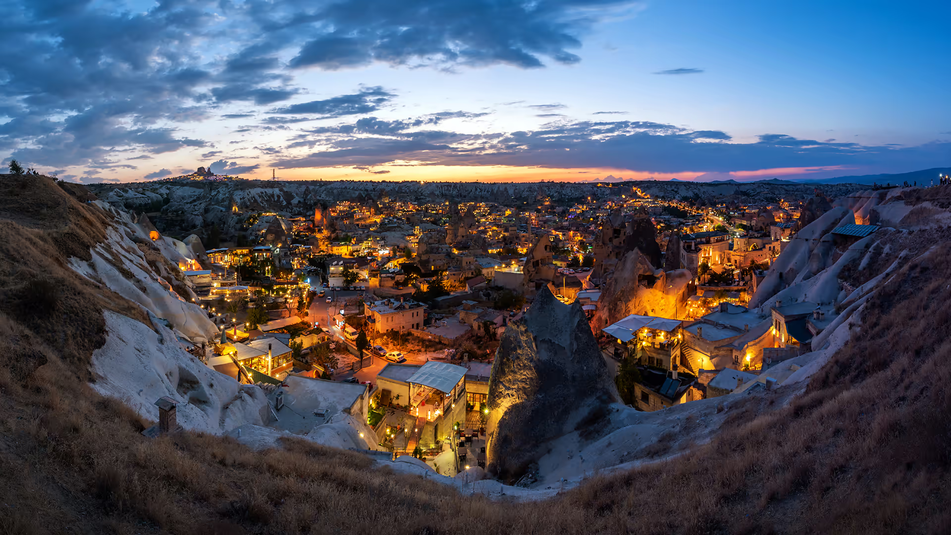
格雷梅的傍晚, 卡帕多西亚, 土耳其 Evening over Göreme, Cappadocia, Türkiye (© ONNAJA/Getty Images)
古老岩石,现代灯光 Ancient rocks, modern lights
格雷梅的傍晚, 卡帕多西亚, 土耳其
黄昏时分,卡帕多西亚格雷梅地区的地貌逐渐显现。这片区域隶属于格雷梅国家公园与卡帕多西亚岩石遗址,1985年入选世界遗产名录。“精灵烟囱”等地貌源自安那托利亚火山喷发形成的火山灰层,随后经风与水长期侵蚀,雕刻出石柱、山脊与谷地。
这些地貌承载着数千年的人类居住史。自晚期古代开始,人们顺着岩石可塑、保温的特性,直接凿刻出住宅、教堂与修道院。不少遗址仍留存10至11世纪的拜占庭壁画,反映出该地区延续已久的宗教生活。画面中灯火通明的小镇凸显了古今交织的景象。今天,格雷梅仍是进入卡帕多西亚步道、观景平台与岩刻遗产的重要入口,这片土地由地质演化与人类坚韧共同塑成。
Evening over Göreme, Cappadocia, Türkiye
As evening settles over the town of Göreme in the heart of the Cappadocia region of Türkiye, dusk reveals a landscape forged by nature and centuries of human presence. This scene is part of Göreme National Park and the Rock Sites of Cappadocia, a UNESCO World Heritage Site inscribed in 1985 for its exceptional combination of early cultural history and geological formations. These formations, often called 'fairy chimneys' or hoodoos, began as layers of volcanic ash that hardened into soft stone following eruptions of ancient Anatolian volcanoes. Over time, wind and water carved the pillars, ridges, and valleys that define the region today.
People have lived among these landforms for millennia. From Late Antiquity onward, residents carved homes, chapels, and monasteries directly into the rock, taking advantage of the stone's workable texture and natural insulating qualities. Many of these structures still contain 10th‑ and 11th‑century Byzantine frescoes, reflecting the region's long-standing tradition of religious life. The illuminated town in today's image highlights how past and present coexist. Today, Göreme remains a gateway to Cappadocia's trails, viewpoints, and rock‑cut heritage—an experience sculpted by geological forces and human resilience.
紫番红花, 里拉七湖, 保加利亚 Purple crocus flowers, Seven Rila Lakes, Bulgaria (© Maya Karkalicheva/Getty Images)

紫番红花, 里拉七湖, 保加利亚 Purple crocus flowers, Seven Rila Lakes, Bulgaria (© Maya Karkalicheva/Getty Images)
聚光灯下的番红花 Crocuses in the spotlight
紫番红花, 里拉七湖, 保加利亚
随着保加利亚西南部里拉山脉冬季寒意减退,番红花从积雪中破土而出,标志着该国最高山脉春天的来临。作为早春花卉,它们利用储存的养分,在寒冷条件下迅速生长,并在更高大的植物出现之前完成生命周期。成簇的花朵在高山草甸上绽放,如紫色缎带般铺展,与雪原形成鲜明对比,在清晨的光线中格外醒目。
番红花在保加利亚里拉国家公园茁壮生长。该公园成立于1992年,是该国最大的自然保护区之一,拥有重要的生态系统,涵盖120多处常年冰川湖和30处季节性冰川湖,里拉七湖群尤为知名。澄澈的湖水与高山地貌相映成景,温暖季节吸引众多游客。初春时节,番红花与融雪交替出现,展现季节更迭的独特画面。
Purple crocus flowers, Seven Rila Lakes, Bulgaria
As winter's grip on the Rila Mountains of southwestern Bulgaria begins to loosen, crocuses push through the thinning snow, signaling the arrival of spring in the country's highest mountain range. These early bloomers use stored nutrients to quickly grow in cold conditions, completing much of their life cycle before taller plants emerge. Their clustered blossoms unfurl over alpine meadows in sweeping purple ribbons, creating a striking contrast with bright snowfields and crisp morning light.
These flowers thrive in Rila National Park, Bulgaria's largest protected area and one of its most significant ecological reserves. Established in 1992, the park safeguards over 120 permanent and around 30 seasonal glacial lakes, including the Seven Rila Lakes, seen in the background of today's image. Renowned for their clear waters and dramatic setting, these high-altitude lakes attract visitors throughout the warmer months. As the season changes, lingering snow and blooming crocuses create one of the region's most memorable seasonal displays, offering a vivid glimpse of the moment winter turns to spring.