布鲁克林大桥,纽约市,美国 Brooklyn Bridge, New York City, USA (© shayes17/Getty Images)

布鲁克林大桥,纽约市,美国 Brooklyn Bridge, New York City, USA (© shayes17/Getty Images)
跨越历史 Crossing into history
布鲁克林大桥,纽约市
布鲁克林大桥连接的不只是曼哈顿和布鲁克林——它还连接着历史、工程学以及几个令人惊讶的故事。大桥历经14年建造,于1883年开放,成为世界上第一座钢丝悬索桥,永久改变了纽约人跨越东河的方式。
这项工程真正称得上是一项全家共同参与的事业。设计师约翰·A·罗布林去世,而他的儿子华盛顿又因病重而无法监督施工后,华盛顿的妻子艾米莉学习了工程学和高等数学,以监督项目的完工。
并非所有人都信任这座新建筑。1884年,演出商P.T.巴纳姆带领21头大象和17峰骆驼走过大桥,以证明它足够坚固。桥内隐藏的拱顶后来曾用于储存葡萄酒和香槟,之后又被用作冷战时期的放射性尘埃避难所;2006年,人们在那里重新发现了被遗忘的应急物资。如今,游隼在大桥的石塔顶部筑巢,证明这座标志性地标仍有许多翱翔高空的居民。有些桥梁就是永不过时。
Brooklyn Bridge, New York City
The Brooklyn Bridge doesn't just connect Manhattan and Brooklyn—it bridges history, engineering, and a few surprising stories too. Opened in 1883 after 14 years of construction, it became the world's first steel-wire suspension bridge, forever changing the way New Yorkers crossed the East River.
The project was a true family affair. After designer John A. Roebling died and his son Washington became too ill to oversee construction, Washington's wife, Emily, learned engineering and higher mathematics to supervise the project's completion.
Not everyone trusted the new structure. In 1884, showman P.T. Barnum marched 21 elephants and 17 camels across the bridge to prove it was strong enough. Hidden vaults inside the bridge later stored wine and champagne before serving as Cold War fallout shelters, where forgotten emergency supplies were rediscovered in 2006. Today, peregrine falcons nest atop its stone towers, proving this iconic landmark still has plenty of high-flying residents. Some bridges simply never go out of style.
林恩运河中浮出水面的虎鲸,奇尔卡特山脉附近,阿拉斯加州,美国 An orca surfaces in Lynn Canal near the Chilkat Mountains, Alaska, USA (© John Hyde/Alamy)

林恩运河中浮出水面的虎鲸,奇尔卡特山脉附近,阿拉斯加州,美国 An orca surfaces in Lynn Canal near the Chilkat Mountains, Alaska, USA (© John Hyde/Alamy)
鲸群之声 Voices of the pod
奇尔卡特山脉附近的虎鲸,林恩运河,阿拉斯加州
在阿拉斯加东南部白雪覆盖的奇尔卡特山脉映衬下,一头虎鲸浮出林恩运河水面。虎鲸是海豚科体型最大的成员,也是海洋中最具辨识度的捕食者之一。阿拉斯加内湾航道寒冷且营养丰富的水域提供了充足的觅食地,既维系鲑鱼洄游,也滋养种类繁多的海洋生物,为这些非凡动物提供支持。
科学家确认了数个不同的虎鲸种群,各自拥有独特的食谱、狩猎策略和社会传统。有些专门捕鱼,有些则捕食海豹、海狮及其他海洋哺乳动物。虎鲸生活在由经验丰富的年长雌鲸带领、关系紧密的家族群体中,并通过每个鲸群特有的叫声交流——这种声音传统代代相传。林恩运河及其周边水道为这些高度聪明的海洋哺乳动物提供了重要栖息地,也是野外观察它们的壮丽场所。
An orca near the Chilkat Mountains, Lynn Canal, Alaska
An orca breaks the surface of Lynn Canal against the backdrop of the snow-capped Chilkat Mountains in Southeast Alaska. Also known as the killer whale, the orca is the largest member of the dolphin family and one of the ocean's most recognizable predators. The cold, nutrient-rich waters of Alaska's Inside Passage provide abundant feeding grounds, sustaining salmon runs and a rich variety of marine life that supports these remarkable animals.
Scientists recognize several distinct orca populations, each with its own diet, hunting strategies, and social traditions. Some specialize in catching fish, while others prey on seals, sea lions, and other marine mammals. Living in tightly bonded family groups led by experienced older females, orcas communicate through distinctive calls unique to each pod—vocal traditions passed down through generations. Lynn Canal and its surrounding waterways offer a vital habitat for these highly intelligent marine mammals and a dramatic setting for observing them in the wild.
圣胡安县阿什斯利帕荒野地的奇岩柱,新墨西哥州,美国 Hoodoos in Ah Shi Sle Pah Wilderness in San Juan County, New Mexico, USA (© Westend61/Getty Images)

圣胡安县阿什斯利帕荒野地的奇岩柱,新墨西哥州,美国 Hoodoos in Ah Shi Sle Pah Wilderness in San Juan County, New Mexico, USA (© Westend61/Getty Images)
绝妙的平衡术 The great balancing act
新墨西哥州阿什斯利帕荒野地
大自然善于平衡看似不可能之物。在新墨西哥州阿什斯利帕荒野地,高耸的石林以纤细石柱托起厚重岩帽。约7,500万年来,风、水和冰将这片偏远的恶地雕刻成一座露天展馆,景象更像异星,而非地球。
这里最常被拍摄的地貌之一,是绰号恰如其分的“外星王座”。这座引人注目的石林已成为当地非官方的明星。纳瓦霍语名称Ah-Shi-Sle-Pah源自“áshiih libá”,意为灰盐。这片荒野曾是沼泽海岸平原,遍布晚白垩世化石,包括恐龙、史前鳄鱼、龟和鱼。1921年,化石猎人查尔斯·哈泽利厄斯·斯腾伯格在这里发现了已知首批窗盾五角龙遗骸——这是北美体型最大的有角恐龙之一。石化木也散布于景观之中。这里没有官方步道或设施,游客须具备扎实的导航技能。沉醉景色很容易;迷失方向则可以避免。
Ah Shi Sle Pah Wilderness, New Mexico
Nature has a knack for balancing the impossible. In New Mexico's Ah-Shi-Sle-Pah Wilderness, towering hoodoos perch hefty rock caps on slender stems. Wind, water, and ice have spent roughly 75 million years sculpting these remote badlands into an open-air gallery that feels more alien than terrestrial.
Among its most photographed formations is the aptly nicknamed 'Alien Throne,' a striking hoodoo that has become the area's unofficial celebrity. The Navajo name Ah-Shi-Sle-Pah, derived from 'áshįįh łibá,' means gray salt. Once a swampy coastal plain, the wilderness is packed with Late Cretaceous fossils, including dinosaurs, prehistoric crocodiles, turtles, and fish. In 1921, fossil hunter Charles Hazelius Sternberg discovered the first known remains of Pentaceratops fenestratus—one of North America's largest horned dinosaurs—here. Petrified wood also dots the landscape. There are no official trails or facilities, so visitors need solid navigation skills. Getting lost in the scenery is easy; losing your way is optional.
约书亚树国家公园,加利福尼亚州,美国 Joshua Tree National Park, California, USA (© JJ Landscapes/Getty Images)

约书亚树国家公园,加利福尼亚州,美国 Joshua Tree National Park, California, USA (© JJ Landscapes/Getty Images)
两片沙漠交汇之地 Where two deserts collide
加利福尼亚州约书亚树国家公园
两片大沙漠交汇之处,约书亚树国家公园展现出由风、时间和极端环境塑造的冷峻迷人景观。在南加利福尼亚州,海拔较高的莫哈韦沙漠与更炎热、地势更低的科罗拉多沙漠相融,形成独特的生态系统组合与非凡的生物多样性。
在近80万英亩的土地上,满身尖刺的约书亚树——其实是一种丝兰——从沙质平原拔地而起,扭曲的轮廓点缀着遍布风化花岗岩巨石的旷野。巨大的岩层在数百万年间开裂、受蚀成形,吸引攀岩者和徒步者在崎岖地形中寻找路线。
生命以非凡方式在这里延续。沙漠大角羊、爬行动物和数百种鸟类在水源稀少、烈日炙烤的环境中繁衍。春天可能带来野花盛放,澄澈夜空则展现出全美最幽暗的星空之一,是观星佳地。1936年的今天,这片广袤景观被指定为国家纪念地,1994年成为国家公园。它邀人探索,令人难忘地领略美国沙漠原始的美与坚韧。
Joshua Tree National Park, California
Where two great deserts meet, Joshua Tree National Park reveals a stark, mesmerizing landscape shaped by wind, time, and extremes. In Southern California, the higher Mojave Desert merges with the hotter, lower Colorado Desert, creating a unique blend of ecosystems and remarkable biodiversity.
Across nearly 800,000 acres, spiky Joshua trees—actually a species of yucca—rise from sandy plains, their twisting silhouettes punctuating fields of weathered granite boulders. Massive rock formations, cracked and sculpted over millions of years, attract climbers and hikers seeking routes through this rugged terrain. Life persists here in remarkable ways. Desert bighorn sheep, reptiles, and hundreds of bird species thrive in an environment defined by scarce water and intense sun. Spring may bring bursts of wildflowers, while crystal-clear nights reveal some of the darkest skies in the country—ideal for stargazing.
Designated as a national monument on this day in 1936, the vast landscape became a national park in 1994. It invites exploration, offering an unforgettable encounter with the raw beauty and resilience of the American desert.
圣胡安岛石灰窑灯塔,华盛顿州,美国 Lime Kiln Lighthouse on San Juan Island, Washington State, USA (© Edmund Lowe Photography/Shutterstock)

圣胡安岛石灰窑灯塔,华盛顿州,美国 Lime Kiln Lighthouse on San Juan Island, Washington State, USA (© Edmund Lowe Photography/Shutterstock)
指引船只穿越历史 Guiding ships through history
全国灯塔日
每年的8月7日是“全国灯塔日”,这一节日旨在颂扬那些数百年来指引船只安全航行于美国沿海的灯塔。这一日期是为了纪念乔治·华盛顿总统签署生效的《1789年灯塔法案》。
在华盛顿州的圣胡安岛(San Juan Island),石灰窑灯塔(Lime Kiln Lighthouse)生动地展现了那段历史。这座灯塔建于1919年,矗立在俯瞰哈罗海峡(Haro Strait)的岩石峭壁之上,其发出的白色闪光至今仍指引着船只安全航行。附近的石灰窑点州立公园(Lime Kiln Point State Park)则因更令人兴奋的景象而闻名——那就是虎鲸。游客常在岸边眺望海面,有时能看到这些强壮的鲸鱼从离岸不远处游过。
从灯塔看守人在漫长风暴之夜坚守岗位,到如今自动化系统的广泛应用,灯塔在不断演变的同时,始终保持着其核心作用。尽管许多灯塔已成为历史地标与观景胜地,但在导航技术高度发达的今天,它们依然是安全、坚韧与探险精神的永恒象征。
National Lighthouse Day
Every August 7, National Lighthouse Day shines a light on the beacons that have guided ships safely along America's coasts for centuries. The date commemorates the Lighthouse Act of 1789, signed into law by President George Washington.
On Washington's San Juan Island, Lime Kiln Lighthouse brings that history vividly to life. Built in 1919 on a rocky bluff overlooking Haro Strait, its white flash still guides vessels through these waters. Nearby, Lime Kiln Point State Park is famous for something even more thrilling: orcas. Visitors often scan the waves from shore and may spot these powerful whales passing close to land.
From keepers tending lamps through long, stormy nights to today's automated systems, lighthouses have evolved while preserving their essential role. Many now serve as historic landmarks and scenic viewpoints, yet even in the age of advanced navigation, they remain enduring symbols of safety, resilience, and adventure.
大批熔岩流涌入大洋,大岛,夏威夷州,美国 A series of lava flows spill into the ocean, Big Island, Hawaii, USA (© Ken McCurdy/Getty Images)

大批熔岩流涌入大洋,大岛,夏威夷州,美国 A series of lava flows spill into the ocean, Big Island, Hawaii, USA (© Ken McCurdy/Getty Images)
基拉韦厄火山的威力 The power of Kīlauea
大岛上的熔岩流涌入海洋, 夏威夷
大多数地貌的演变历时数千年,而火山却能在短短数小时内重塑地貌——在夏威夷大岛,这一过程至今仍在持续。为了保护这一不断变化的环境及其所蕴含的科学与自然价值,夏威夷火山国家公园于1916年8月1日正式成立。一个多世纪以来,该公园一直致力于保护这片占地超过35万英亩的区域,其中包括火山地貌、原生森林以及各类珍稀野生动植物。
这座国家公园以其境内的两座火山——基拉韦厄和冒纳罗亚——命名。基拉韦厄是世界上最活跃的火山之一;在某些喷发期间,熔岩会顺坡而下流入太平洋,冷却后形成新的岩石。冒纳罗亚则是按体积计算全球最大的活火山,自1843年有明确记录的首次喷发以来,已喷发过34次。该公园也是多种珍稀生物的家园,其中包括夏威夷的州鸟——夏威夷雁,以及濒临灭绝的夏威夷圆尾鹱。值此周年纪念之际,这座公园继续守护着这片不断演变的动态景观。
Lava flows spill into the ocean on Big Island, Hawaii
Most landscapes change over thousands of years. Volcanoes can reshape them in a matter of hours, and on Hawaii's Big Island, they continue to do just that. Recognizing the scientific and natural importance of this ever-changing environment, Hawaii Volcanoes National Park was established on August 1, 1916. For more than a century, it has protected over 350,000 acres of volcanic terrain, native forests, and rare wildlife.
The national park is named after its two volcanoes—Kīlauea and Mauna Loa. Kīlauea is one of the world's most active volcanoes, and during some eruptions, its lava flows downhill to the Pacific Ocean, where it cools into new rock. Mauna Loa, the world's largest active volcano by volume, has erupted 34 times since its first well-documented eruption in 1843. The park is also home to species such as the nēnē, Hawaii's state bird, and the endangered Hawaiian petrel. As it marks another anniversary today, the park continues to protect a landscape that never stands still.
鸟瞰弗吉尼亚爬山虎步道,达马斯克斯,弗吉尼亚州,美国 Aerial view of the Virginia Creeper Trail, Damascus, Virginia, USA (© Eifel Kreutz/Getty Images)

鸟瞰弗吉尼亚爬山虎步道,达马斯克斯,弗吉尼亚州,美国 Aerial view of the Virginia Creeper Trail, Damascus, Virginia, USA (© Eifel Kreutz/Getty Images)
穿越时光的足迹 Trailing through time
弗吉尼亚爬山虎步道, 达马斯克斯, 弗吉尼亚州
有些铁路会退出历史舞台,而“弗吉尼亚爬山虎步道”则实现了华丽转身。这条步道全长34.3英里,横贯弗吉尼亚州西南部,沿用了一条昔日的铁路线——该线路曾用于在阿巴拉契亚山脉间运输木材和铁矿石。步道那独特的名字,源自20世纪初那些在陡峭坡道上艰难爬行的蒸汽机车。
这条步道以被誉为“美国步道之城”的大马士革为中心,因其47座木制栈桥、壮丽的山景和丰富的户外探险活动而闻名。大马士革也是为数不多的阿巴拉契亚步道直接穿过镇中心主街的地点之一。
这条步道的一大亮点是从怀特托普站到大马士革长达17英里的下坡骑行路段;怀特托普站是全线最高点,海拔3,500英尺。骑行者几乎无需踩踏踏板,即可顺势滑行下降约1,600英尺。另一处引人注目的景观是“高架栈桥”,这是一座长550英尺、高出下方山谷100英尺的桥梁。受2024年“海伦”飓风破坏影响,该步道的上段目前因修复工作而关闭,而大马士革至阿宾登的路段则继续开放。
Virginia Creeper Trail, Damascus, Virginia
Some railways retire. The Virginia Creeper Trail simply changed gears. Stretching 34.3 miles through southwest Virginia, this trail follows a former rail line once used to haul lumber and iron ore through the Appalachian Mountains. Its unusual name traces back to the steam locomotives that labored up steep grades in the early 1900s.
Centered around Damascus, known as 'Trail Town USA,' the trail is famous for its 47 wooden trestles, sweeping mountain views, and outdoor adventures. Damascus is also one of the few places where the Appalachian Trail passes directly through a town's Main Street.
One of the trail's highlights is a 17-mile downhill ride from Whitetop Station, the route's highest point at 3,500 feet, to Damascus. Riders can coast nearly 1,600 feet downhill with little pedaling. Another standout feature is the High Trestle, a 550-foot bridge that rises 100 feet above the valley below. Following damage from Hurricane Helene in 2024, the upper section remains closed for restoration, while the Damascus-to-Abingdon section continues to stay open.
在纳瓦霍族保留地的纪念碑谷,亚利桑那州,美国 Monument Valley, Navajo Nation, Arizona, USA (© Westend61/Adobe Stock)

在纳瓦霍族保留地的纪念碑谷,亚利桑那州,美国 Monument Valley, Navajo Nation, Arizona, USA (© Westend61/Adobe Stock)
旷野无声,活态传承之境 A landscape of living heritage
纪念碑谷在纳瓦霍族保留地,亚利桑那州,美国
在纳瓦霍族保留地,亚利桑那州与犹他州交界处,美国,有些景观举世闻名,而纪念碑谷则堪称传奇。这一沙漠奇观横跨州界,其地貌由高耸的砂岩孤峰塑造而成,这些孤峰从谷底拔地而起,高度可达1000英尺。在纳瓦霍语中,该地区被称为 Tsé Bii' Ndzisgaii(意为“岩石之谷”),它将壮丽的地质构造与鲜活的民族文化完美融合。
山谷标志性的红色源于砂岩中蕴含的氧化铁与锰;而纳瓦霍传说则讲述了另一个故事:著名的米滕孤峰——这些标志性的砂岩地貌——是巨人在一场大战后散落在地上的双手。自导演约翰·福特在《关山飞渡》和《搜索者》等经典影片中将其作为取景地后,纪念碑谷便成为了好莱坞公认的“西部荒野”背景。如今,游客可以驻足于“约翰·福特点”,这是该地区最著名的取景地之一。
一条17英里长的自驾景观路揭示了山谷的标志性地标,而由纳瓦霍人向导带领的深度游则提供了进入私人领地和获取更深层文化洞察的机会。在这里,每一处岩石地貌都承载着属于自己的独特故事。
Monument Valley, Navajo Nation, Arizona
Some landscapes are famous. Monument Valley is legendary. Straddling the Arizona–Utah border within the Navajo Nation, this desert wonder is shaped by towering sandstone buttes that rise as much as 1,000 feet above the valley floor. Known in Navajo as Tsé Bii' Ndzisgaii—'valley of the rocks'—the region blends dramatic geology with living culture.
The valley's iconic red hue comes from iron oxide and manganese in the sandstone, while Navajo legend tells a different story: the famous Mitten Buttes—iconic sandstone formations—are the hands of a giant scattered across the Earth after a great battle. Monument Valley became Hollywood's go-to Wild West backdrop after director John Ford featured it in classics such as 'Stagecoach' and 'The Searchers.' Today, visitors can stop at John Ford's Point, one of the area's most photographed viewpoints.
A self-guided, 17-mile scenic drive reveals the valley's landmarks, while Navajo-led tours provide access to hidden sites and deeper cultural insights. Here, every rock formation carries its own story.
蒂芙尼穹顶,芝加哥文化中心,伊利诺伊州,美国 Tiffany Dome, Chicago Cultural Center, Illinois, USA (© Felix Lipov/Shutterstock)
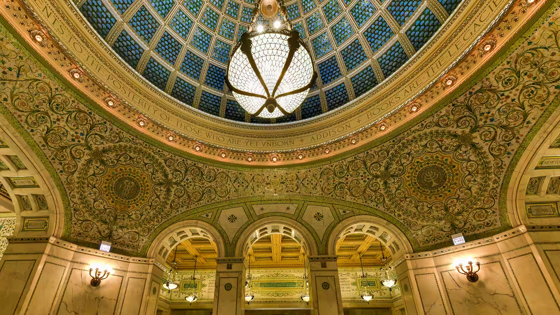
蒂芙尼穹顶,芝加哥文化中心,伊利诺伊州,美国 Tiffany Dome, Chicago Cultural Center, Illinois, USA (© Felix Lipov/Shutterstock)
仰望芝城,流光溢彩 Chicago, look up!
蒂芙尼穹顶在芝加哥文化中心,美国
步入位于美国,伊利诺伊州,芝加哥文化中心的建筑内部,目光瞬间会被上方绚丽夺目的彩色顶棚——蒂芙尼穹顶所吸引。这座艺术杰作悬挂在普雷斯顿·布拉德利大厅上方,直径约38英尺,由约30,000片法夫里尔玻璃组成,每片玻璃都呈鱼鳞状。阳光透过其半透明的表面,在错综复杂的图案中映射出变幻莫测的蓝色与金色。
该建筑于1897年作为芝加哥首座中央公共图书馆正式开放,旨在展示卓越的工艺水准与公民自豪感。如今,它已转型为一个免费的文化枢纽,承载着各类展览、演出及公共项目。
该穹顶曾长期隐藏在保护性外层之下,于2008年完成全面修复,让自然光重新照进这一历史空间。在光影映衬下,建筑结构与艺术美学有机融合,将曾经的阅读室转变为这座城市最震撼的室内景观之一。
Tiffany Dome, Chicago Cultural Center, Illinois
Step inside the Chicago Cultural Center, and your eyes are instantly drawn upward to a glowing canopy of color—the Tiffany Dome. Suspended above Preston Bradley Hall, this masterpiece spans approximately 38 feet in diameter and is composed of roughly 30,000 pieces of Favrile glass, each shaped like a fish scale. Sunlight filters through its translucent surface, shifting blues and golds across its intricate pattern.
The building beneath it opened in 1897 as Chicago's first central public library, designed to showcase craftsmanship and civic pride. Today, it serves as a free cultural hub, hosting exhibitions, performances, and public programs.
Once hidden beneath a protective outer layer, the dome was fully restored in 2008, reintroducing natural light to this historic space. Beneath its glow, architecture and artistry merge, transforming a former reading room into one of the city's most striking interiors.
海军码头,芝加哥,伊利诺伊州,美国 Navy Pier, Chicago, Illinois, USA (© Christopher.F Photography/Getty Images)

海军码头,芝加哥,伊利诺伊州,美国 Navy Pier, Chicago, Illinois, USA (© Christopher.F Photography/Getty Images)
滨水变色龙 A waterfront chameleon
海军码头,芝加哥,伊利诺伊州
有些地方的建造目的单一,而有些地方则不断推陈出新。位于伊利诺伊州芝加哥的海军码头就属于后者。这座码头向湖中延伸超过3000英尺,是爱德华·H·贝内特和丹尼尔·伯纳姆于1909年制定的芝加哥规划的一部分。码头于1916年开放,最初是为了服务于密歇根湖上的航运、休闲娱乐和客运而建。为了纪念第一次世界大战的海军老兵,码头被更名为海军码头。
今天走出户外,你会发现周围的景象截然不同。天际线占据了视野,密歇根湖则远眺码头之外。晴朗的日子里,玻璃幕墙高楼与开阔湖面的鲜明对比令人过目难忘。
如今,这座码头集公园、表演场地、餐厅、家庭娱乐设施、博物馆和各种滨水活动于一体。许多游客都知道百年摩天轮,但鲜为人知的是,二战后这里曾是大学生的上课场所。一座建筑,承载着多种人生。对于芝加哥的地标建筑而言,这的确是一份不同寻常的履历。
Navy Pier, Chicago, Illinois
Some places are built for a single purpose; others keep reinventing themselves. Navy Pier in Chicago, Illinois, falls into the second category. The structure stretches more than 3,000 feet into the lake and was designed as part of Edward H. Bennett's and Daniel Burnham's 1909 Plan of Chicago. Opened in 1916, the pier was built for shipping, recreation, and passenger travel on Lake Michigan. It was renamed Navy Pier in honor of World War I naval veterans.
Step outside today and the surroundings feel very different. The skyline fills the view, while Lake Michigan stretches far beyond the pier. On clear days, the contrast between glass towers and open water is hard to miss.
The pier is now home to parks, performance spaces, restaurants, family attractions, a museum, and waterfront activities. Many visitors know the Centennial Wheel, but fewer know that the pier once housed university students attending classes after World War II. One structure, many lives. That's an unusual resume for a Chicago landmark.