在纳瓦霍族保留地的纪念碑谷,亚利桑那州,美国 Monument Valley, Navajo Nation, Arizona, USA (© Westend61/Adobe Stock)

在纳瓦霍族保留地的纪念碑谷,亚利桑那州,美国 Monument Valley, Navajo Nation, Arizona, USA (© Westend61/Adobe Stock)
旷野无声,活态传承之境 A landscape of living heritage
纪念碑谷在纳瓦霍族保留地,亚利桑那州,美国
在纳瓦霍族保留地,亚利桑那州与犹他州交界处,美国,有些景观举世闻名,而纪念碑谷则堪称传奇。这一沙漠奇观横跨州界,其地貌由高耸的砂岩孤峰塑造而成,这些孤峰从谷底拔地而起,高度可达1000英尺。在纳瓦霍语中,该地区被称为 Tsé Bii' Ndzisgaii(意为“岩石之谷”),它将壮丽的地质构造与鲜活的民族文化完美融合。
山谷标志性的红色源于砂岩中蕴含的氧化铁与锰;而纳瓦霍传说则讲述了另一个故事:著名的米滕孤峰——这些标志性的砂岩地貌——是巨人在一场大战后散落在地上的双手。自导演约翰·福特在《关山飞渡》和《搜索者》等经典影片中将其作为取景地后,纪念碑谷便成为了好莱坞公认的“西部荒野”背景。如今,游客可以驻足于“约翰·福特点”,这是该地区最著名的取景地之一。
一条17英里长的自驾景观路揭示了山谷的标志性地标,而由纳瓦霍人向导带领的深度游则提供了进入私人领地和获取更深层文化洞察的机会。在这里,每一处岩石地貌都承载着属于自己的独特故事。
Monument Valley, Navajo Nation, Arizona
Some landscapes are famous. Monument Valley is legendary. Straddling the Arizona–Utah border within the Navajo Nation, this desert wonder is shaped by towering sandstone buttes that rise as much as 1,000 feet above the valley floor. Known in Navajo as Tsé Bii' Ndzisgaii—'valley of the rocks'—the region blends dramatic geology with living culture.
The valley's iconic red hue comes from iron oxide and manganese in the sandstone, while Navajo legend tells a different story: the famous Mitten Buttes—iconic sandstone formations—are the hands of a giant scattered across the Earth after a great battle. Monument Valley became Hollywood's go-to Wild West backdrop after director John Ford featured it in classics such as 'Stagecoach' and 'The Searchers.' Today, visitors can stop at John Ford's Point, one of the area's most photographed viewpoints.
A self-guided, 17-mile scenic drive reveals the valley's landmarks, while Navajo-led tours provide access to hidden sites and deeper cultural insights. Here, every rock formation carries its own story.
蒂芙尼穹顶,芝加哥文化中心,伊利诺伊州,美国 Tiffany Dome, Chicago Cultural Center, Illinois, USA (© Felix Lipov/Shutterstock)
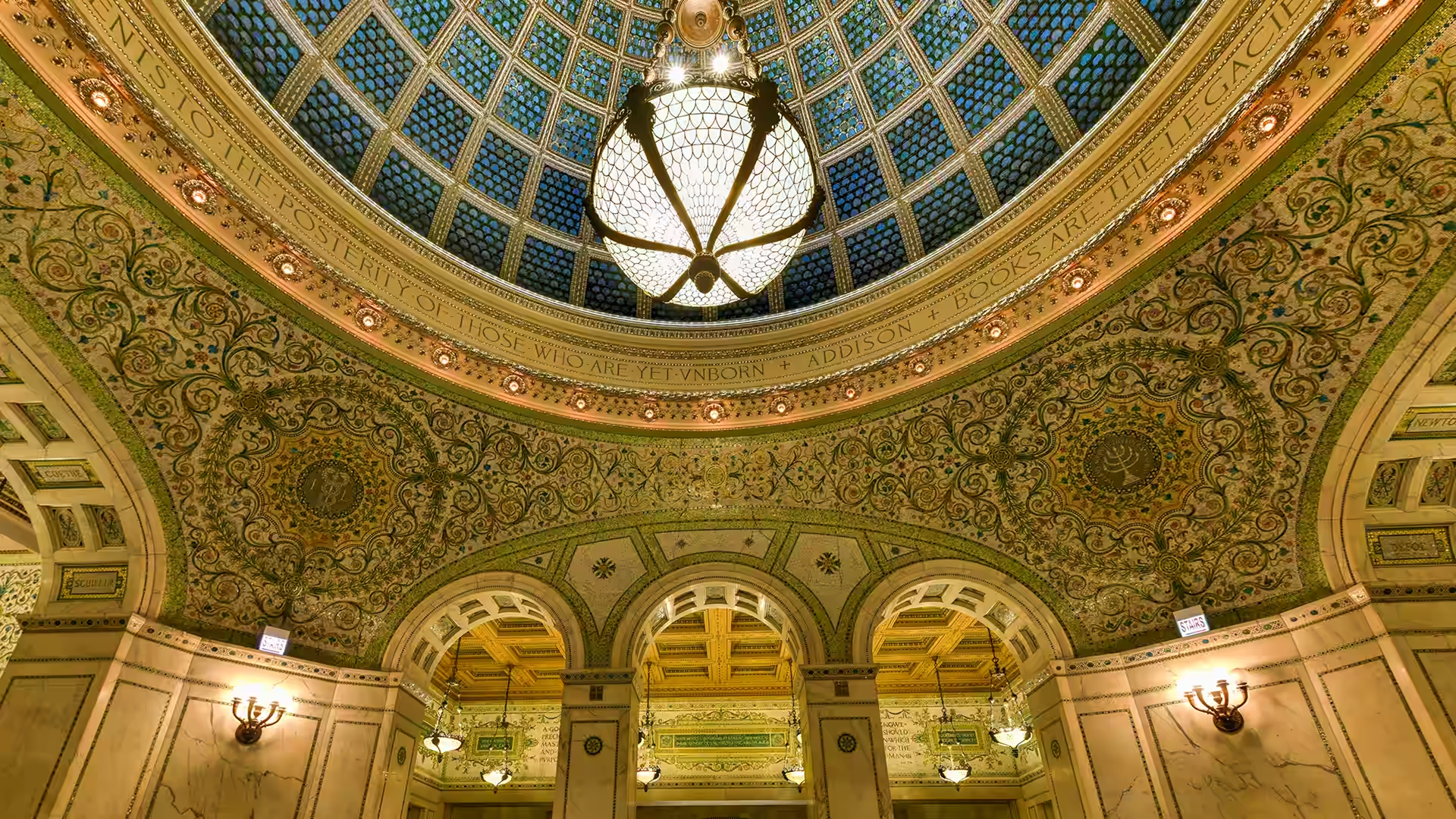
蒂芙尼穹顶,芝加哥文化中心,伊利诺伊州,美国 Tiffany Dome, Chicago Cultural Center, Illinois, USA (© Felix Lipov/Shutterstock)
仰望芝城,流光溢彩 Chicago, look up!
蒂芙尼穹顶在芝加哥文化中心,美国
步入位于美国,伊利诺伊州,芝加哥文化中心的建筑内部,目光瞬间会被上方绚丽夺目的彩色顶棚——蒂芙尼穹顶所吸引。这座艺术杰作悬挂在普雷斯顿·布拉德利大厅上方,直径约38英尺,由约30,000片法夫里尔玻璃组成,每片玻璃都呈鱼鳞状。阳光透过其半透明的表面,在错综复杂的图案中映射出变幻莫测的蓝色与金色。
该建筑于1897年作为芝加哥首座中央公共图书馆正式开放,旨在展示卓越的工艺水准与公民自豪感。如今,它已转型为一个免费的文化枢纽,承载着各类展览、演出及公共项目。
该穹顶曾长期隐藏在保护性外层之下,于2008年完成全面修复,让自然光重新照进这一历史空间。在光影映衬下,建筑结构与艺术美学有机融合,将曾经的阅读室转变为这座城市最震撼的室内景观之一。
Tiffany Dome, Chicago Cultural Center, Illinois
Step inside the Chicago Cultural Center, and your eyes are instantly drawn upward to a glowing canopy of color—the Tiffany Dome. Suspended above Preston Bradley Hall, this masterpiece spans approximately 38 feet in diameter and is composed of roughly 30,000 pieces of Favrile glass, each shaped like a fish scale. Sunlight filters through its translucent surface, shifting blues and golds across its intricate pattern.
The building beneath it opened in 1897 as Chicago's first central public library, designed to showcase craftsmanship and civic pride. Today, it serves as a free cultural hub, hosting exhibitions, performances, and public programs.
Once hidden beneath a protective outer layer, the dome was fully restored in 2008, reintroducing natural light to this historic space. Beneath its glow, architecture and artistry merge, transforming a former reading room into one of the city's most striking interiors.
红树上的日出在小猪群岛,洪都拉斯 Sunrise on a red mangrove in the Pig Keys, Honduras (© Mac Stone/Tandem Stills + Motion)

红树上的日出在小猪群岛,洪都拉斯 Sunrise on a red mangrove in the Pig Keys, Honduras (© Mac Stone/Tandem Stills + Motion)
海陆际会,生机肇始 Between land and sea, life begins
保护红树林生态系统国际日
在洪都拉斯小猪群岛的日出时分——那是掩映在红树林湿地中低矮的沿海小岛——一株红树将其交错的根系挺立于如镜的水面之上。这幅动人的画面精准捕捉了7月26日所庆祝的主题:保护红树林生态系统国际日,该节日的设立旨在呼吁全球关注这些至关重要的海岸森林。
红树林在咸水与陆地的交汇处生机盎然,利用特化的根系在柔软且贫氧(Oxygen-poor)的泥层中固着,它们密集的根系网络能够减缓波浪冲击、减轻侵蚀,并保护沿海社区免受风暴侵袭。在水面之下,这些根系为幼鱼、螃蟹和虾类提供了庇护所,使这些湿地成为海洋中最具生产力的育幼场之一。
在像洪都拉斯这样的地区,红树林资源丰富的沿海湿地还储存着大量的碳,并维持着当地的生计。然而,这些生态系统正在迅速消失,使得生态保育变得迫在眉睫。注视着日出穿透那些拱形枝干的光芒——你正在见证地球上最强大的天然防御屏障之一正在发挥作用。
International Day for the Conservation of the Mangrove Ecosystem
At sunrise in Honduras' Pig Keys—small, low-lying coastal islets tucked within mangrove-rich wetlands—a red mangrove lifts its tangled roots above glassy water. This striking scene captures what July 26 celebrates: the International Day for the Conservation of the Mangrove Ecosystem, created to spotlight these vital coastal forests.
Mangroves thrive where saltwater and land collide, using specialized roots to anchor in soft, oxygen-poor mud. Their dense networks calm waves, reduce erosion, and shield communities from storms. Beneath the surface, those same roots shelter young fish, crabs, and shrimp, making these wetlands one of the ocean's most productive nurseries.
In places like Honduras, mangrove-rich coastal wetlands also store large amounts of carbon and support local livelihoods. Yet these ecosystems are disappearing rapidly, making conservation urgent. Watch the sunrise glow through those arching branches, —and you're witnessing one of Earth's most powerful natural defenses at work.
大教堂海滩,加利西亚,西班牙 Praia das Catedrais, Galicia, Spain (© Tui De Roy/Amazing Aerial Agency/Abobe Stock)

大教堂海滩,加利西亚,西班牙 Praia das Catedrais, Galicia, Spain (© Tui De Roy/Amazing Aerial Agency/Abobe Stock)
加境幽廊 Into Galicia's hidden arches
大教堂海滩,加利西亚,西班牙
在西班牙遥远的西北部,加利西亚与大西洋交汇。漫长的海岸线在海浪的强力冲刷下,形成了由悬崖、内湾和海蚀平台交织而成的地貌。雨水充沛的山丘与密林向海绵延,这种景观带有鲜明的大西洋气候基调,使其在感官上更接近于爱尔兰,而非人们惯常印象中的西班牙南部。
在该地区的北缘,里瓦德奥小镇毗邻阿斯图里亚斯自治区,坐落于比斯开湾的河口与外海交汇处。这里的海岸线从崎岖嶙峋转为超现实的奇观,悬崖之后隐匿着复杂的岩石构造和幽静的海湾。大教堂海滩得名于经年累月的海蚀作用所雕琢出的巨型拱门,其宏伟的轮廓酷似哥特式石质大教堂的高耸建筑风格。
潮落之时是最佳的到访时刻。在有限的时间窗内,裸露的海床会化为一座可供步行的“石头迷宫”——这一瞬息万变的地形会随着潮水的再度涌入而消失,海洋迅速收复沙滩并重塑海岸线的形态。
Praia das Catedrais, Galicia, Spain
In Spain's far northwest, Galicia meets the Atlantic with force—its long coastline carved by waves into cliffs, inlets, and wave-cut platforms. Rain-fed hills and dense forests spill toward the sea, creating a landscape that feels closer to Ireland than southern Spain, with shifting skies and a distinctly Atlantic mood.
On the region's northern edge, the town of Ribadeo sits near the border with Asturias on the Bay of Biscay, where estuaries meet the open ocean. The coastline here shifts from rugged to surreal, with cliffs suddenly giving way to complex rock formations and hidden coves. Praia das Catedrais—'Beach of the Cathedrals'—takes its name from massive arches sculpted by the ocean over time, their shapes resembling the soaring architecture of stone cathedrals.
Visit when the tide drops. For a limited stretch of time, the exposed seabed becomes a walkable maze of stone—an ever-changing terrain that disappears again as the ocean surges back in, quickly reclaiming the sand and reshaping the shoreline.
珊瑚礁与海滩在拉贾安帕特,印度尼西亚 Coral reef and beach in Raja Ampat, Indonesia (© SergeUWPhoto/Shutterstock)

珊瑚礁与海滩在拉贾安帕特,印度尼西亚 Coral reef and beach in Raja Ampat, Indonesia (© SergeUWPhoto/Shutterstock)
细微之举,影响深远 Small footprint, big impact
珊瑚礁意识周
想象一座由动物建造的城市,在阳光下熠熠生辉,并在海浪之下涌动着生命。这就是珊瑚礁。在珊瑚礁意识周(Coral Reef Awareness Week)期间,我们赞美这些非凡的生态系统,以及依赖其生存的无数物种
珊瑚礁仅覆盖了全球不足1%的海床面积,却支撑着约25%的海洋生命。这些看似彩色岩石的物体,实际上是被称为珊瑚虫(Coral polyps)的微小动物集群。它们共同构建了宏大的石灰岩结构,且能延续数千年之久。大堡礁是地球上最大的生物结构,沿着澳大利亚海岸延伸超过1,400英里。
珊瑚礁充满了惊喜。部分珊瑚因含有能起到天然防晒作用的荧光蛋白而发光;而鹦嘴鱼则通过将珊瑚转化为细砂,协助形成了沙滩。若想一窥珊瑚礁生命最丰富的一面,请看向图中所示的印度尼西亚拉贾安帕特(Raja Ampat),那里生长着超过75%的已知珊瑚物种。它们虽栖息于水下,但其影响力远播至海岸线之外。
Coral Reef Awareness Week
Imagine a city built by animals, glowing in the sunlight, and bustling with life beneath the waves. That is a coral reef. During Coral Reef Awareness Week, we celebrate these remarkable ecosystems and the countless species that depend on them.
Coral reefs cover less than 1% of the ocean floor, yet they support roughly 25% of all marine life. What look like colorful rocks are actually colonies of tiny animals called coral polyps. Together, they build vast limestone structures that can last for thousands of years. The Great Barrier Reef is the largest living structure on Earth, stretching more than 1,400 miles along Australia's coast.
Reefs are full of surprises. Some corals glow thanks to fluorescent proteins that act like natural sunscreen, while parrotfish help create sandy beaches by turning coral into fine sand. For a glimpse of reef life at its richest, look to Raja Ampat in Indonesia, pictured here, where more than 75% of known coral species thrive. They may live underwater, but their impact reaches far beyond the shore.
圣卡塔琳娜拱门,安提瓜,危地马拉 Santa Catalina Arch, Antigua, Guatemala (© Filippo Maria Bianchi/Getty Images)

圣卡塔琳娜拱门,安提瓜,危地马拉 Santa Catalina Arch, Antigua, Guatemala (© Filippo Maria Bianchi/Getty Images)
拱影寻踪 Hidden in plain arch
圣卡塔琳娜拱门,安提瓜,危地马拉
有些建筑的初衷并非为了引人注目,但时间却另有安排。清晨时分,圣卡塔琳娜拱门在危地马拉安提瓜的街道上熠熠生辉,其鲜艳的黄色外墙精准地捕捉着晨光,石板路向前延伸,远方的水火山拔地而起。这座拱门建于17世纪,旨在解决一个实际问题:幽居修女需要在修道院建筑之间穿行,以符合宗教誓约中不被街道行人直视的要求。正是这种对隐私的克制,而非对景观的追求,造就了如今中美洲出镜率最高的地标之一。讽刺的是,这种反差随时间的沉淀而愈发迷人。
安提瓜市本身就体现了这种矛盾性。该市于1979年被列入联合国教科文组织世界遗产名录,在保留其殖民时期方格网街道布局的同时,也承载着多次重塑其地貌的地震印记。从街头望去,这座曾为了“遮掩”而建的建筑,如今却成为了框定整座城市美景的构图框架。火山在后方屹立不动,而拱门依然在履行它始终如一的职责——无论有意与否,静静地连接着历史与现在。
Santa Catalina Arch, Antigua, Guatemala
Some structures weren't meant to stand out—but time had other ideas. At sunrise, the Santa Catalina Arch glows over the streets of Antigua, Guatemala, its yellow facade catching the light just right as cobblestones stretch ahead and Agua Volcano rises in the distance. The arch was built in the 17th century to solve a practical problem: cloistered nuns needed to cross between convent buildings without being seen from the street. Privacy, not postcards, created one of Central America's most photographed landmarks. Irony holds up well over time.
Antigua itself leans into that contradiction. Declared a UNESCO World Heritage Site in 1979, the city preserves its colonial grid while carrying the marks of earthquakes that repeatedly reshaped it. Seen here from the street, this structure built to conceal now frames the city. The volcano holds steady behind it, and the arch keeps doing what it has always done—connecting things quietly, intentionally or not.
月球与地球由阿耳忒弥斯2号机组人员拍摄 Moon and Earth captured by the Artemis II crew (© NASA)

月球与地球由阿耳忒弥斯2号机组人员拍摄 Moon and Earth captured by the Artemis II crew (© NASA)
月瞰寰宇 The lunar perspective
国际月球日
从月球那遍布环形山的表面望去,地球在无垠的黑暗中呈现为一抹微光闪烁的娥眉状——这一罕见的奇观与我们惯常的地面观测视角截然相反。这片由数十亿年撞击作用塑造的荒芜地貌,完整地保存了早期太阳系的演化记录。7月20日是国际月球日,旨在纪念1969年阿波罗11号任务中人类首次踏上月球表面的历史性时刻。该纪念日由联合国于2021年设立,不仅致敬过去的辉煌成就,更聚焦于当下持续不断的月球探测努力。
月球作为地球唯一的天然卫星,在距离地球约23.9万英里的轨道上运行。由于几乎不存在大气层,月球经历着极端的温差跨度——受光面的酷热与阴影区的严寒形成了鲜明对比。然而,月球的影响力远超其表面:它的引力是驱动地球海洋潮汐的核心动力,将这个寂静且真空的世界与人类的日常生活紧密相连。月球不仅是太空探索的目的地,更是夜空中永恒的存在,连接着人类早期的天文观测与当代的深空探测。
International Moon Day
From the moon's cratered surface, Earth appears as a thin, glowing crescent against the darkness—a rare view that reverses our usual perspective. This stark landscape, shaped by billions of years of impacts, preserves a record of the early solar system. July 20 marks International Moon Day, commemorating the 1969 Apollo 11 landing, when humans first set foot on the lunar surface. Established by the United Nations in 2021, the day highlights past achievements and ongoing efforts to explore the moon.
Orbiting about 239,000 miles from Earth, the moon is Earth's only natural satellite. With almost no atmosphere, it experiences extreme temperature contrasts between sunlit heat and shadowed cold. Yet its influence reaches far beyond its surface—its gravity helps drive ocean tides on Earth, linking this quiet, airless world to everyday life. More than a destination for exploration, the moon remains a constant presence in our skies, connecting early observations of the night sky to ongoing exploration today.
恶魔桥在克罗姆劳杜鹃花公园,萨克森州,德国 Devil's Bridge in Rhododendron Park Kromlau, Saxony, Germany (© Mike Mareen/Getty Images)

恶魔桥在克罗姆劳杜鹃花公园,萨克森州,德国 Devil's Bridge in Rhododendron Park Kromlau, Saxony, Germany (© Mike Mareen/Getty Images)
环影圆成 Going full circle
恶魔桥在克罗姆劳,萨克森州,德国
倒映在平静的水面上,拉科茨桥——通称为“恶魔桥”——在德国萨克森州构成了一个近乎完美的石环。这座窄长的玄武岩结构始建于1860年,经过精密的工程设计,使其拱形结构与水面倒影在湖面静止时能精准对齐,形成一个无缝的圆环。该建筑由当地产的火山石建成,与其说它具有实用功能,不如说它体现了精准的几何设计,其惊艳的造型纯粹是为了追求视觉上的美学冲击。作为热门的摄影题材,它还曾出现在包括《黑客帝国:矩阵重启》(2021年)在内的电影中。如今,由于桥体结构脆弱,为了对其进行保护,严禁行人通行,游客仅可从岸边观赏。
该桥坐落于克罗姆劳杜鹃花公园,这是一座靠近波兰边境的英式景观园林。林间小径蜿蜒穿过湖泊与季节性花卉展区,每逢春季,杜鹃花与映山红竞相绽放,呈现出绚丽夺目的色彩。在水面最为平静的时刻,水石交融,构成了一个迷人的幻象,仿佛悬浮在现实与倒影之间的虚幻之境。
Devil's Bridge, Kromlau, Saxony, Germany
Reflected in still water, the Rakotzbrücke—commonly known as the Devil's Bridge—forms a near-perfect stone circle in Saxony, Germany. Commissioned in 1860, the narrow basalt structure was carefully engineered so that its arch and reflection align to form a seamless ring when the lake is still. Made from locally sourced volcanic stone, it reflects precise design rather than practical function, its striking geometry intended purely for visual effect. A popular photo subject, it has also appeared in films, including 'The Matrix Resurrections' (2021). Today, the fragile bridge can only be admired from the shore, as crossing is prohibited to preserve it.
The bridge stands in Rhododendron Park Kromlau, an English-style landscape garden near the Polish border. Woodland paths wind past lakes and seasonal flower displays, with rhododendrons and azaleas creating vivid bursts of color in spring. At its calmest, water and stone align to form an enchanting illusion that appears to hover between reality and reflection.
瓦伊海滩上的日光浴躺椅,克里特岛,希腊 Sunbeds on the beach at Vai, Crete, Greece (© borchee/Getty Images)

瓦伊海滩上的日光浴躺椅,克里特岛,希腊 Sunbeds on the beach at Vai, Crete, Greece (© borchee/Getty Images)
希腊式的逃离 A Greek escape
瓦伊,克里特岛,希腊
在克里特岛的东北角,坐落着一个远离游客喧嚣的静谧之地瓦伊。这片区域的核心景观是其海滩:金黄色的沙滩沿着平静的爱琴海浅水缓缓展开,设有躺椅、遮阳伞与淋浴设施,为游泳、放松或安静休憩提供理想场所。瓦伊最引人注目的特色在于其沙滩背后有着欧洲最大的天然棕榈林。该棕榈林由5000多棵克里特枣椰树构成,这是一种仅分布于克里特岛及土耳其部分地区的特有树种。
20世纪70年代初,瓦伊被一群嬉皮士“重新发现”。他们在被驱离马塔拉村后,将瓦伊作为避世之地。然而,随着1980年代游客数量骤增、基础设施缺乏,瓦伊的环境一度遭受严重破坏。鉴于其独特的生态与文化价值,当局将瓦伊划为保护区。经过多年管理与恢复,如今的瓦伊不仅是克里特岛最原始、最美丽的自然瑰宝之一,也成为负责任旅游与生态保护的典范。这片海滩的复苏,清晰展现了可持续管理对自然环境所能产生的积极影响。
Vai, Crete, Greece
On the remote northeastern tip of the island of Crete in Greece lies Vai—a quiet corner far from the usual tourist trail. At the heart of this region is its beach, a broad curve of golden sand kissed by the calm, shallow waters of the Aegean. With sunbeds, umbrellas, and showers, it's an ideal spot for swimming, relaxing, or simply soaking in the peaceful atmosphere. But what truly sets Vai apart lies just behind the sand: Europe's largest natural palm grove. It is made up of over 5,000 Cretan date palm trees, a species unique to Crete and parts of Türkiye.
In the early 1970s, Vai was 'rediscovered' by hippies, who made it their haven after being moved out of the village of Matala. By the 1980s, however, increasing numbers of visitors and a lack of infrastructure had left the area littered and degraded. Recognizing its ecological and cultural value, authorities declared Vai a protected zone. Cleanup efforts restored the area, and today, Vai is one of Crete's most beautiful and unspoiled natural treasures. It's a reminder of how careful stewardship can bring a place back to life.
海军码头,芝加哥,伊利诺伊州,美国 Navy Pier, Chicago, Illinois, USA (© Christopher.F Photography/Getty Images)

海军码头,芝加哥,伊利诺伊州,美国 Navy Pier, Chicago, Illinois, USA (© Christopher.F Photography/Getty Images)
滨水变色龙 A waterfront chameleon
海军码头,芝加哥,伊利诺伊州
有些地方的建造目的单一,而有些地方则不断推陈出新。位于伊利诺伊州芝加哥的海军码头就属于后者。这座码头向湖中延伸超过3000英尺,是爱德华·H·贝内特和丹尼尔·伯纳姆于1909年制定的芝加哥规划的一部分。码头于1916年开放,最初是为了服务于密歇根湖上的航运、休闲娱乐和客运而建。为了纪念第一次世界大战的海军老兵,码头被更名为海军码头。
今天走出户外,你会发现周围的景象截然不同。天际线占据了视野,密歇根湖则远眺码头之外。晴朗的日子里,玻璃幕墙高楼与开阔湖面的鲜明对比令人过目难忘。
如今,这座码头集公园、表演场地、餐厅、家庭娱乐设施、博物馆和各种滨水活动于一体。许多游客都知道百年摩天轮,但鲜为人知的是,二战后这里曾是大学生的上课场所。一座建筑,承载着多种人生。对于芝加哥的地标建筑而言,这的确是一份不同寻常的履历。
Navy Pier, Chicago, Illinois
Some places are built for a single purpose; others keep reinventing themselves. Navy Pier in Chicago, Illinois, falls into the second category. The structure stretches more than 3,000 feet into the lake and was designed as part of Edward H. Bennett's and Daniel Burnham's 1909 Plan of Chicago. Opened in 1916, the pier was built for shipping, recreation, and passenger travel on Lake Michigan. It was renamed Navy Pier in honor of World War I naval veterans.
Step outside today and the surroundings feel very different. The skyline fills the view, while Lake Michigan stretches far beyond the pier. On clear days, the contrast between glass towers and open water is hard to miss.
The pier is now home to parks, performance spaces, restaurants, family attractions, a museum, and waterfront activities. Many visitors know the Centennial Wheel, but fewer know that the pier once housed university students attending classes after World War II. One structure, many lives. That's an unusual resume for a Chicago landmark.