布鲁克林大桥,纽约市,美国 Brooklyn Bridge, New York City, USA (© shayes17/Getty Images)

布鲁克林大桥,纽约市,美国 Brooklyn Bridge, New York City, USA (© shayes17/Getty Images)
跨越历史 Crossing into history
布鲁克林大桥,纽约市
布鲁克林大桥连接的不只是曼哈顿和布鲁克林——它还连接着历史、工程学以及几个令人惊讶的故事。大桥历经14年建造,于1883年开放,成为世界上第一座钢丝悬索桥,永久改变了纽约人跨越东河的方式。
这项工程真正称得上是一项全家共同参与的事业。设计师约翰·A·罗布林去世,而他的儿子华盛顿又因病重而无法监督施工后,华盛顿的妻子艾米莉学习了工程学和高等数学,以监督项目的完工。
并非所有人都信任这座新建筑。1884年,演出商P.T.巴纳姆带领21头大象和17峰骆驼走过大桥,以证明它足够坚固。桥内隐藏的拱顶后来曾用于储存葡萄酒和香槟,之后又被用作冷战时期的放射性尘埃避难所;2006年,人们在那里重新发现了被遗忘的应急物资。如今,游隼在大桥的石塔顶部筑巢,证明这座标志性地标仍有许多翱翔高空的居民。有些桥梁就是永不过时。
Brooklyn Bridge, New York City
The Brooklyn Bridge doesn't just connect Manhattan and Brooklyn—it bridges history, engineering, and a few surprising stories too. Opened in 1883 after 14 years of construction, it became the world's first steel-wire suspension bridge, forever changing the way New Yorkers crossed the East River.
The project was a true family affair. After designer John A. Roebling died and his son Washington became too ill to oversee construction, Washington's wife, Emily, learned engineering and higher mathematics to supervise the project's completion.
Not everyone trusted the new structure. In 1884, showman P.T. Barnum marched 21 elephants and 17 camels across the bridge to prove it was strong enough. Hidden vaults inside the bridge later stored wine and champagne before serving as Cold War fallout shelters, where forgotten emergency supplies were rediscovered in 2006. Today, peregrine falcons nest atop its stone towers, proving this iconic landmark still has plenty of high-flying residents. Some bridges simply never go out of style.
在处暑时节的村庄田野与寺庙佛塔,江阴市,江苏省,中国 Village fields and a temple pagoda during the End of Heat solar term, Jiangyin City, Jiangsu Province, China (© jia yu/Getty Images)

在处暑时节的村庄田野与寺庙佛塔,江阴市,江苏省,中国 Village fields and a temple pagoda during the End of Heat solar term, Jiangyin City, Jiangsu Province, China (© jia yu/Getty Images)
暑气渐消,金秋已至 The receding heat brings golden autum
处暑时节
处暑时节将至,航拍视角下的古塔迎着晨雾耸立于渐染秋色的林木之间,生动呈现了暑气消退、金秋将至的自然韵律,以及中国传统文化景观的悠久魅力 。这一时节的传统习俗包括放河灯、迎秋赏景以及饮用中草药煎剂(如凉茶/防暑汤),以调和四季交替时的身体平衡 。
尤利尔山口蜿蜒的公路,瑞士 Winding road of Julier Pass, Switzerland (© Westend61/Getty Images)

尤利尔山口蜿蜒的公路,瑞士 Winding road of Julier Pass, Switzerland (© Westend61/Getty Images)
攀登在召唤 The climb is calling
尤利尔山口蜿蜒的公路,瑞士
有些山路本身就会成为旅行目的地,尤利尔山口正是其中之一。这座瑞士山口海拔高达7,493英尺,近2,000年来一直沿着一条路线连接着阿尔卑斯山的各个山谷。它的故事早在现代交通出现之前便已开始。没有护栏,也没有路面——只有一条供罗马时代的旅行者、商人和信使使用的路线。山顶附近的考古发现,包括无数枚硬币和两根罗马时期的皂石柱,表明这里可能曾有一处供攀越山口的人使用的圣所或歇脚处。
今天图片中所见的公路建于1820年至1828年间。1935年至1940年间,这座山口成为瑞士第一条铺设沥青的阿尔卑斯山公路。如今,每天约有3,000辆车通过尤利尔山口。冬季路况恶劣时,驾驶者可能需要安装防滑链。每一个回头弯都会带来又一番壮丽景色,让这段车程与目的地同样令人难忘。如果钥匙在你手中,你会选择这条风景优美的路线吗?
Winding road of Julier Pass, Switzerland
Some mountain roads become destinations in their own right, and Julier Pass is one of them. This Swiss mountain pass rises to 7,493 feet and has linked Alpine valleys along a route used for nearly 2,000 years. Its story began long before modern traffic. No guardrails, no pavement—just a route used by Roman travelers, merchants, and messengers. Archaeological finds near the summit, including countless coins and two Roman soapstone columns, suggest there was once a sanctuary or stopping place for those tackling the climb.
The road seen in today's image was built between 1820 and 1828. From 1935 to 1940, the pass became the first Swiss alpine road to be paved with asphalt. Today, roughly 3,000 vehicles cross Julier Pass every day. In winter, drivers may need snow chains when conditions are severe. Every switchback comes with another spectacular view, making the drive as memorable as the destination. If you had the keys, would you take the scenic route?
林恩运河中浮出水面的虎鲸,奇尔卡特山脉附近,阿拉斯加州,美国 An orca surfaces in Lynn Canal near the Chilkat Mountains, Alaska, USA (© John Hyde/Alamy)

林恩运河中浮出水面的虎鲸,奇尔卡特山脉附近,阿拉斯加州,美国 An orca surfaces in Lynn Canal near the Chilkat Mountains, Alaska, USA (© John Hyde/Alamy)
鲸群之声 Voices of the pod
奇尔卡特山脉附近的虎鲸,林恩运河,阿拉斯加州
在阿拉斯加东南部白雪覆盖的奇尔卡特山脉映衬下,一头虎鲸浮出林恩运河水面。虎鲸是海豚科体型最大的成员,也是海洋中最具辨识度的捕食者之一。阿拉斯加内湾航道寒冷且营养丰富的水域提供了充足的觅食地,既维系鲑鱼洄游,也滋养种类繁多的海洋生物,为这些非凡动物提供支持。
科学家确认了数个不同的虎鲸种群,各自拥有独特的食谱、狩猎策略和社会传统。有些专门捕鱼,有些则捕食海豹、海狮及其他海洋哺乳动物。虎鲸生活在由经验丰富的年长雌鲸带领、关系紧密的家族群体中,并通过每个鲸群特有的叫声交流——这种声音传统代代相传。林恩运河及其周边水道为这些高度聪明的海洋哺乳动物提供了重要栖息地,也是野外观察它们的壮丽场所。
An orca near the Chilkat Mountains, Lynn Canal, Alaska
An orca breaks the surface of Lynn Canal against the backdrop of the snow-capped Chilkat Mountains in Southeast Alaska. Also known as the killer whale, the orca is the largest member of the dolphin family and one of the ocean's most recognizable predators. The cold, nutrient-rich waters of Alaska's Inside Passage provide abundant feeding grounds, sustaining salmon runs and a rich variety of marine life that supports these remarkable animals.
Scientists recognize several distinct orca populations, each with its own diet, hunting strategies, and social traditions. Some specialize in catching fish, while others prey on seals, sea lions, and other marine mammals. Living in tightly bonded family groups led by experienced older females, orcas communicate through distinctive calls unique to each pod—vocal traditions passed down through generations. Lynn Canal and its surrounding waterways offer a vital habitat for these highly intelligent marine mammals and a dramatic setting for observing them in the wild.
怀特克利夫公园,西温哥华,加拿大 Whytecliff Park, West Vancouver, Canada (© Aolin Chen/Getty Images)

怀特克利夫公园,西温哥华,加拿大 Whytecliff Park, West Vancouver, Canada (© Aolin Chen/Getty Images)
浪潮间的通道 A path between the waves
怀特克利夫公园,西温哥华,加拿大
通往此处的最佳路径并非由混凝土铺就。每当退潮时,一条岩石小径便会显露出来,连接着加拿大西温哥华的怀特克利夫公园(Whytecliff Park)与怀特小岛(Whyte Islet)。数小时后,海水会悄然漫过这条通道,将“把握时机”也变成了体验的一部分。这片海岸线吸引着一代又一代的游客:潮汐开辟了道路,而湿滑的岩石则让人心存敬畏;作为回报,你将收获回望海滩与格伦伊格尔斯(Gleneagles)山坡民居时的壮丽景致。
怀特克利夫公园(Whytecliff Park)得名于曾矗立在这段海岸线上的浅色悬崖;1993年,其周边海域成为加拿大首个咸水海洋保护区,从而在历史上留下了浓墨重彩的一笔。如今,这片海域栖息着200多种海洋生物,使该公园成为水肺潜水爱好者和野生动物观察者的热门去处。人们常能看到港海豹在近岸处出没,甚至还有虎鲸曾在此海域现身。游览完公园后,游客还可以前往灯塔公园(Lighthouse Park)探索一番,或是徒步前往赛普拉斯瀑布公园(Cypress Falls Park)欣赏瀑布美景,为一天的行程画上圆满句号。
弗留利要塞城市帕尔马诺瓦航拍图,意大利 Aerial view of Palmanova, a fortress city in Friuli, Italy (© Riccardo Saponi/Getty Images)

弗留利要塞城市帕尔马诺瓦航拍图,意大利 Aerial view of Palmanova, a fortress city in Friuli, Italy (© Riccardo Saponi/Getty Images)
星形城市的几何之美 Geometry of a star city
弗留利要塞城市帕尔马诺瓦航拍图,意大利
从空中俯瞰,帕尔马诺瓦与其说是一座城镇,不如说是一颗精心绘制、嵌入意大利弗留利-威尼斯朱利亚平原的星。威尼斯共和国于1593年建立这座要塞城市,其设计兼顾防御、秩序与宏伟观感。街道从中央广场向外辐射,城墙则构成精确的九角星形。这种几何形态绝非偶然。帕尔马诺瓦成为近代早期军事建筑最具影响力的典范之一。其同心式防御工事最初由威尼斯修建,后来在拿破仑时期得到加固和扩建。
如今,这座城市属于联合国教科文组织世界遗产“16至17世纪威尼斯共和国防御工事”。航拍视角让其理念一目了然:美感与战略融于同一设计。穿过城门和棱堡,星形便不再只是形状,而是化为一座为从空中阅读而建的城市。
Aerial view of Palmanova, a fortress city in Friuli, Italy
From above, Palmanova looks less like a town and more like a carefully drawn star set into the plains of Friuli-Venezia Giulia, Italy. Founded by the Republic of Venice in 1593, this fortress city was designed for defense, order, and spectacle. Its streets radiate from a central square, while its walls are shaped into a precise nine-pointed pattern. That geometry was no accident. Palmanova became one of the most influential models of early modern military architecture. It was protected by concentric fortifications built first under Venice and later strengthened and expanded during the Napoleonic period.
Today, the city is part of the UNESCO World Heritage Site 'Venetian Works of Defence between the 16th and 17th Centuries.' Its aerial view reveals the concept at a glance: beauty and strategy combined in a single design. Walk through its gates and bastions, and the star becomes more than a shape—it becomes a city meant to be read from the sky.
戈尔韦郡罗斯埃里利方济各会修道院遗址,康诺特省,爱尔兰 Ruins of Ross Errilly Friary, County Galway, Ireland (© Maria Janus/Shutterstock)
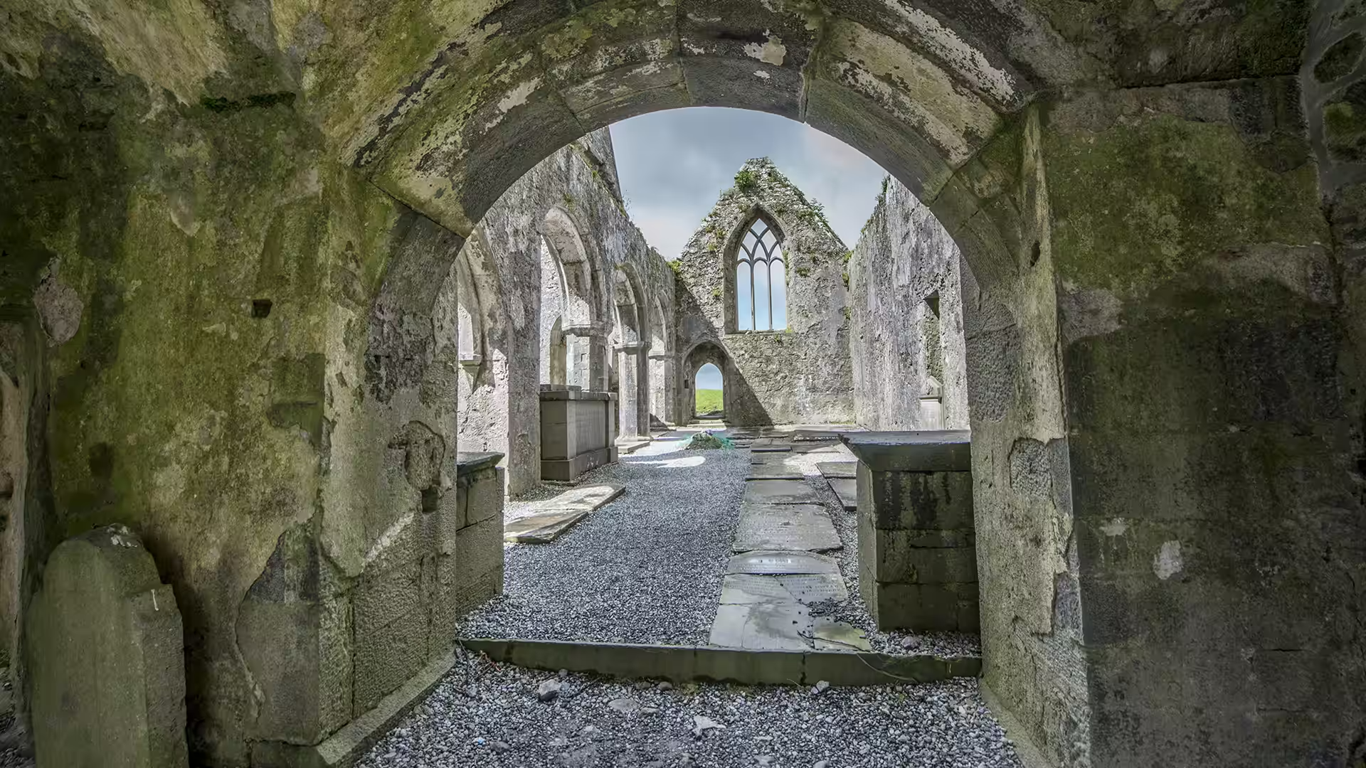
戈尔韦郡罗斯埃里利方济各会修道院遗址,康诺特省,爱尔兰 Ruins of Ross Errilly Friary, County Galway, Ireland (© Maria Janus/Shutterstock)
天鹅开启传奇之处 Where swans started a legend
罗斯·埃里利修道院遗址,戈尔韦郡,爱尔兰
天鹅、秘密藏身处和中世纪养鱼池有什么共同之处?它们都是罗斯埃里利方济各会修道院遗址故事的一部分。这座保存完好的爱尔兰方济各会修道院建于约1351年,常被称为罗斯修道院(俗称);不过它从未设过院长,因为它本就不是隐修院。
当地传说称,一位主教跟随三只嘴衔亚麻籽的天鹅来到这里,随后选定了院址。修道院日渐兴盛,最终增建了少见的第二座回廊,以容纳不断壮大的社群。中世纪厨房里甚至设有巧妙的活水石池,可让刚捕获的鱼一直存活到用餐时。
罗斯埃里利也熬过了数百年的宗教迫害。修士们在修道院屡次关闭后仍不断返回;克伦威尔时期,这里后来还庇护过天主教神职人员。修道院废弃后,墓葬活动仍持续很久,如今有些墓碑已成为步道的一部分。这里证明,历史确实会留下长久的足迹——有时还是字面意义上的足迹。
Ross Errilly Friary, County Galway, Ireland
What do swans, secret hideaways, and a medieval fish tank have in common? They're all part of the story of Ross Errilly Friary. Founded around 1351, this well-preserved Franciscan friary in Ireland is often called Ross Abbey, though it never had an abbot because it was never an abbey.
Local legend says a bishop chose the site after following three swans carrying flax seed in their beaks. The friary flourished, eventually adding a rare second cloister to accommodate its growing community. Its medieval kitchen even featured a clever running-water stone tank that kept freshly caught fish alive until mealtime.
Ross Errilly also weathered centuries of religious persecution. Friars returned despite repeated closures, and the site later sheltered Catholic clergy during the Cromwellian period. Burials continued long after the monastery was abandoned, with some tombstones now forming parts of its walkways. This site proves history can leave lasting footprints—sometimes quite literally.
圣胡安县阿什斯利帕荒野地的奇岩柱,新墨西哥州,美国 Hoodoos in Ah Shi Sle Pah Wilderness in San Juan County, New Mexico, USA (© Westend61/Getty Images)

圣胡安县阿什斯利帕荒野地的奇岩柱,新墨西哥州,美国 Hoodoos in Ah Shi Sle Pah Wilderness in San Juan County, New Mexico, USA (© Westend61/Getty Images)
绝妙的平衡术 The great balancing act
新墨西哥州阿什斯利帕荒野地
大自然善于平衡看似不可能之物。在新墨西哥州阿什斯利帕荒野地,高耸的石林以纤细石柱托起厚重岩帽。约7,500万年来,风、水和冰将这片偏远的恶地雕刻成一座露天展馆,景象更像异星,而非地球。
这里最常被拍摄的地貌之一,是绰号恰如其分的“外星王座”。这座引人注目的石林已成为当地非官方的明星。纳瓦霍语名称Ah-Shi-Sle-Pah源自“áshiih libá”,意为灰盐。这片荒野曾是沼泽海岸平原,遍布晚白垩世化石,包括恐龙、史前鳄鱼、龟和鱼。1921年,化石猎人查尔斯·哈泽利厄斯·斯腾伯格在这里发现了已知首批窗盾五角龙遗骸——这是北美体型最大的有角恐龙之一。石化木也散布于景观之中。这里没有官方步道或设施,游客须具备扎实的导航技能。沉醉景色很容易;迷失方向则可以避免。
Ah Shi Sle Pah Wilderness, New Mexico
Nature has a knack for balancing the impossible. In New Mexico's Ah-Shi-Sle-Pah Wilderness, towering hoodoos perch hefty rock caps on slender stems. Wind, water, and ice have spent roughly 75 million years sculpting these remote badlands into an open-air gallery that feels more alien than terrestrial.
Among its most photographed formations is the aptly nicknamed 'Alien Throne,' a striking hoodoo that has become the area's unofficial celebrity. The Navajo name Ah-Shi-Sle-Pah, derived from 'áshįįh łibá,' means gray salt. Once a swampy coastal plain, the wilderness is packed with Late Cretaceous fossils, including dinosaurs, prehistoric crocodiles, turtles, and fish. In 1921, fossil hunter Charles Hazelius Sternberg discovered the first known remains of Pentaceratops fenestratus—one of North America's largest horned dinosaurs—here. Petrified wood also dots the landscape. There are no official trails or facilities, so visitors need solid navigation skills. Getting lost in the scenery is easy; losing your way is optional.
扎克舒夫附近的野生动物通道,波兰 Aerial view of a wildlife crossing near Zakrzów, Poland (© bbsferrari/Getty Images)

扎克舒夫附近的野生动物通道,波兰 Aerial view of a wildlife crossing near Zakrzów, Poland (© bbsferrari/Getty Images)
为动物脚掌而建,而非行人 Built for paws, not people
波兰扎克舒夫附近的野生动物通道
道路解决了一个问题,却悄然制造了另一个问题。人类出行速度前所未有地提高,野生动物世代沿用的迁徙路线却被公路切断,导致碰撞事故增加、栖息地破碎化,野生动物种群彼此隔绝。为应对这一挑战,人们建造了称为生态桥的野生动物通道:这些桥梁或隧道旨在重新连接栖息地,让动物安全穿越繁忙道路。最早的一些现代案例于20世纪50年代出现在法国,这一理念很快传遍欧洲。荷兰等国通过建造覆盖土壤及草本、灌木和乔木等本土植被的宽阔绿色桥梁,推动了生态桥设计的完善。
如今,世界各国都在使用这类通道。在美国,跨线桥和地下通道帮助加拿大马鹿、叉角羚、黑熊和佛罗里达美洲狮等物种安全穿过繁忙公路。有时,最聪明的桥就是那座你几乎注意不到的桥——因为野生动物把它视为森林的一部分,而非公路。
Wildlife crossing near Zakrzów, Poland
Roads solved one problem but quietly created another. People could travel faster than ever, while wildlife now faced highways cutting across routes they had followed for generations. The result was more collisions, fragmented habitats, and isolated wildlife populations. That challenge led to building wildlife crossings called ecoducts: bridges or tunnels designed to reconnect habitats and give animals a safe way across busy roads. Some of the earliest modern examples appeared in France during the 1950s, and the idea soon spread across Europe. Countries such as the Netherlands helped refine ecoduct design by building wide green bridges covered in soil and native vegetation, from grasses and shrubs to trees.
Today, countries around the world use these crossings. In the United States, overpasses and underpasses help species such as elk, pronghorn, black bears, and Florida panthers cross busy highways safely. Sometimes the smartest bridge is the one you barely notice—because wildlife sees it as part of the forest, not the highway.
泰德天文台上空的英仙座流星,加那利群岛,西班牙 Perseid meteors over Teide Observatory, Tenerife, Spain (© Westend61/Getty Images)

泰德天文台上空的英仙座流星,加那利群岛,西班牙 Perseid meteors over Teide Observatory, Tenerife, Spain (© Westend61/Getty Images)
许个愿吧 Make a wish
西班牙特内里费上空的英仙座流星雨
并非所有夏日传统都发生在地面。有些在数百英里高空上演,每次划过一颗流星。英仙座流星雨每年从7月中旬持续至8月下旬,并在8月12日至13日前后达到峰值。世界大部分地区都能看到它;在黑暗天空下,每小时往往会出现数十颗流星。想象自己抬头仰望,一道接一道亮光划过。数到多少颗时,你会忘记数目?每道亮光都来自斯威夫特-塔特尔彗星散落的碎屑,地球穿过其尘埃带时便形成流星。它们看起来像是从英仙座辐射而出。
今天的图片展示了流星雨掠过西班牙特内里费泰德天文台上空的景象。这处高海拔观测点坐落在约7,840英尺高处。海拔高、空气稀薄且光污染程度低,使这里成为观测夜空的绝佳地点。有些英仙座流星会留下持续数秒的发光尾迹,让观星者有足够时间欣赏这场奇观。那么,今年你准备去哪里观看英仙座流星雨?
Perseid meteor shower over Tenerife, Spain
Not every summer tradition happens on the ground. Some take place hundreds of miles overhead, one meteor at a time. The Perseids return every year from mid-July through late August, reaching their peak around August 12-13. Visible across much of the world, they often produce dozens of meteors per hour under dark skies. Picture yourself looking up. One streak appears after another. How many can you spot before you lose count? Each streak comes from debris shed by Comet Swift-Tuttle as Earth moves through its dust trail. The meteors appear to radiate from the constellation Perseus.
Today's image shows the shower above Teide Observatory in Tenerife, Spain. This high-altitude site sits about 7,840 feet above sea level. Its high elevation, thin air, and low levels of light pollution make it an excellent place to observe the night sky. Some Perseid meteors leave glowing trails that linger for several seconds, giving skywatchers just enough time to appreciate the spectacle. So, where will you watch the Perseids this year?